Yuneec Unveils Thermal Camera for Commercial UAVs

By Caroline Rees / 07 Sep 2018

Thermal Cameras

Discover cutting-edge solutions from leading global suppliers
SUPPLIER SPOTLIGHT
Follow UST

Yuneec E10T Thermal Drone Camera

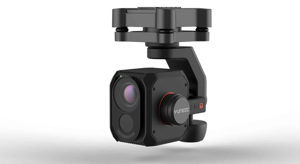
Yuneec International has expanded its commercial UAV payload offering, announcing details of the E10T advanced thermal camera for commercial applications. The E10T is an all-in-one three-axis gimbal, dual thermal imaging and low light camera available in two versions: 320 by 256-pixel or 640 by 512-pixel thermal resolution, each with different lens options. The E10T will be sold separately and available later this year starting at $4,999.

The E10T builds off the original Yuneec CGO-ET dual thermal RGB camera, the industry’s first thermal and residual light combination camera that was announced with the H520 at InterDrone 2017. The E10T camera takes high-quality pictures and detects more detail in dark scenes than the naked eye with the help of its large RGB sensor. Thanks to its dual video stream, users can transmit their thermal and video image simultaneously to the ground station and then view the image as an overlay or picture-in-picture.

Find suppliers of Cameras for UAVs >

“The E10T is the next evolution of the industry’s first thermal and low light RGB combination and will provide commercial users confidence in an array of situations,” said Michael Jiang, CEO, Yuneec International. “With its dual video stream on the 7-inch ST16s ground station coupled with the industry’s only user-variable speed control, pilots can confidently approach critical structures without concern of impact.”

The H520 was specially developed for inspection, safety and search & rescue applications. With its multi-sensor compatibility, the H520 hexacopter offers emergency services, firefighters, police and inspectors reliable and efficient air support in combination with the E10T thermal imaging and video camera. When searching for people, the H520-E10T system enables users to search for people quickly from the air, and in the case of fire, hot spots can be immediately detected, allowing fast and efficient counter measure to help save lives. Moreover, all required object inspection details can be detected while mitigating risk of potential prop strikes. The H520’s live image can be transferred to a monitor during the flight, allowing team members to take part in the inspection and make critical assessments during flight.

The E10T will be available later this year in four lens configurations for the two resolution options. The 320-pixel thermal resolution will start at $4,999, while the 640-pixel thermal resolution will start at $7,999.

Posted by Caroline Rees Caroline co-founded Unmanned Systems Technology and has been at the forefront of the business ever since. With a Masters Degree in marketing Caroline has her finger on the pulse of all things unmanned and is committed to showcasing the very latest in unmanned technical innovation. Connect & Contact

Latest Articles

High-Energy Density Batteries for Drones & Robotic Vehicles

The SCIO Brick® platform offers industry-leading energy density in a compact and lightweight footprint, and can be scaled to meet high-voltage requirements

Jul 12, 2025
Most Read Articles on UST This Week

Here’s our round-up of the five most read articles on UnmannedSystemsTechnology.com this week

Jul 11, 2025
Vertiq Speed Firmware v0.1.1 Now Available with Bug Fixes

Vertiq has released firmware v0.1.1 to correct a parameter bug affecting telemetry and 3D mode settings on select G1 and G2 modules

Jul 11, 2025
The Role of ROVs in Unmanned Marine Operations

Oceanbotics has answered the most common questions about ROVs, covering how they work, where they're used, and key capabilities

Jul 11, 2025
LiveU File Transfer Speeds Up Drone Data Delivery for Critical Missions

LiveU’s File Transfer enables rapid transmission of large drone data files, reducing delays and supporting faster decision-making in public safety and infrastructure operations.

Jul 11, 2025
Exploring Differences Between M9PLUS & M9 GNSS Antennas

Discover the key upgrades in Maxtena’s new M9PLUS GNSS antenna, including improved performance, signal purity, and multipath mitigation over the original M9

Jul 11, 2025

Featured Content

USAF Uses Inertial Labs Drone Lidar for Tree Obstruction Survey

The US Air Force successfully used Inertial Labs drone Lidar and cloud software to quickly map tree obstructions at Joint Base Lewis-McChord (JBLM), improving airfield safety

Jul 11, 2025
New UAV to Combine Solar Hydrogen & Battery Power for Extended Flight

XSun and H3 Dynamics are developing the first UAV powered by solar, hydrogen, and batteries, aiming to deliver zero-emission, long-endurance unmanned flight

Jul 07, 2025
Enhancing Mangrove Restoration Through 3D Printed Drone Design

Explore how Inverto Earth, in collaboration with HP Additive, is using sustainable 3D printing and drone technology to drive large-scale mangrove restoration and protect vulnerable coastal ecosystems

Jul 03, 2025
Advancing Unmanned Systems Through Strategic Collaboration UST works with major OEMs to foster collaboration and increase engagement with SMEs, to accelerate innovation and drive unmanned systems capabilities forward.