Case Study: Using LiDAR for Altimetry & Terrain Following

Feature Article by LightWare LiDAR

Drone LiDAR

Discover cutting-edge solutions from 4 leading global suppliers
SUPPLIER SPOTLIGHT
Follow UST

LightWare LiDAR has released a case study highlighting how the company’s SF30/D LiDAR was used by SPH Engineering for over-water altimetry and terrain following.
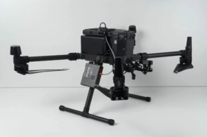
Using LiDAR for Altimetry & Terrain FollowingThe case study covers:

  • Why SPH Engineering chose to work with LightWare
  • The advantages of the SF30/D LiDAR sensor
  • The continued collaboration between SPH Engineering and LightWare LiDAR

To find out more about the SF30/D LiDAR and the benefits it can provide for altimetry and assistance in terrain following. Read the full case study on the LightWare website.

Posted by Caroline Rees Caroline co-founded Unmanned Systems Technology and has been at the forefront of the business ever since. With a Masters Degree in marketing Caroline has her finger on the pulse of all things unmanned and is committed to showcasing the very latest in unmanned technical innovation. Connect & Contact

Featured Content

SBG Systems Evaluates INS Performance in GNSS-Denied Marine Applications

SBG Systems evaluates the performance of its INS solutions in GNSS-denied marine environments, comparing system accuracy with and without DVL and warm-up support

Jul 14, 2025
USAF Uses Inertial Labs Drone Lidar for Tree Obstruction Survey

The US Air Force successfully used Inertial Labs drone Lidar and cloud software to quickly map tree obstructions at Joint Base Lewis-McChord (JBLM), improving airfield safety

Jul 11, 2025
New UAV to Combine Solar Hydrogen & Battery Power for Extended Flight

XSun and H3 Dynamics are developing the first UAV powered by solar, hydrogen, and batteries, aiming to deliver zero-emission, long-endurance unmanned flight

Jul 07, 2025
Advancing Unmanned Systems Through Strategic Collaboration UST works with major OEMs to foster collaboration and increase engagement with SMEs, to accelerate innovation and drive unmanned systems capabilities forward.