Drone as a Service (DaaS) by ZenaDrone

verified This business has been claimed by Drone as a Service (DaaS) by ZenaDrone and verified by UST.
Verified companies work with us to ensure we display the most up-to-date and comprehensive product information, articles and other material to help you choose the right solution for your requirements.
Drone as a Service (DaaS) | Professional Drone Services for Aerial Data Collection United States of America
Visit Website
Saved
Save
Contact
Drone as a Service (DaaS) by ZenaDrone

Drone as a Service (DaaS) | Professional Drone Services for Aerial Data Collection

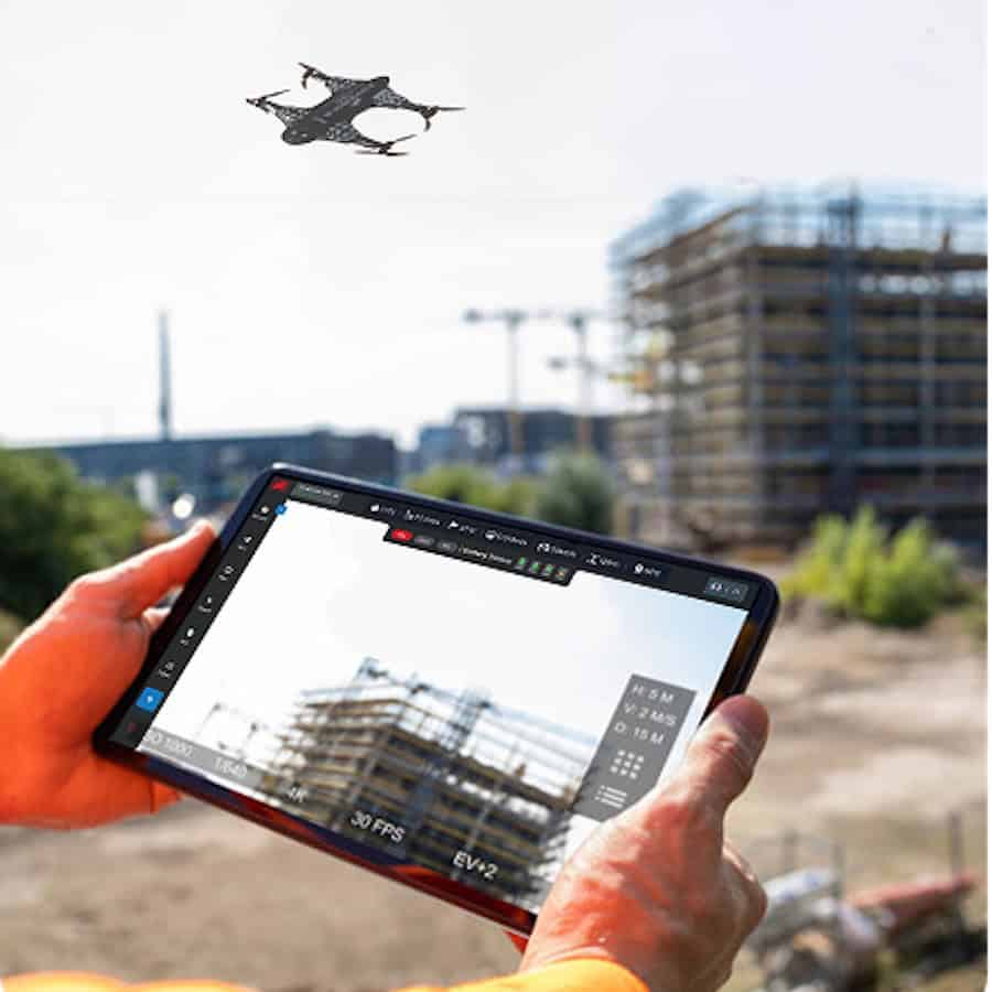
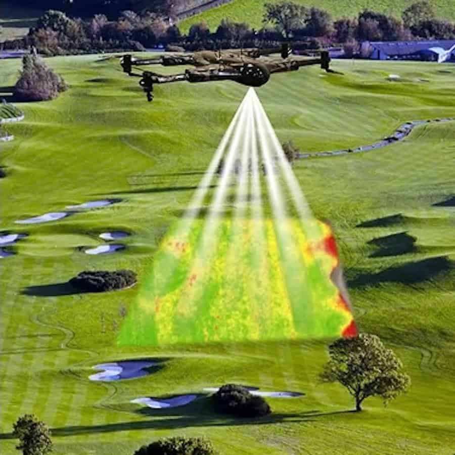
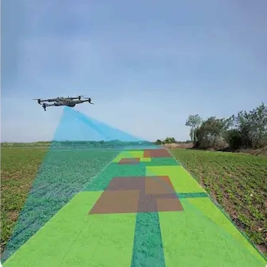
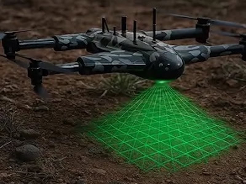
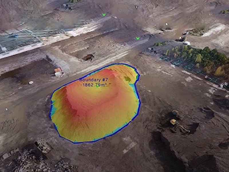
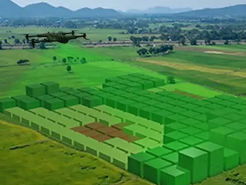
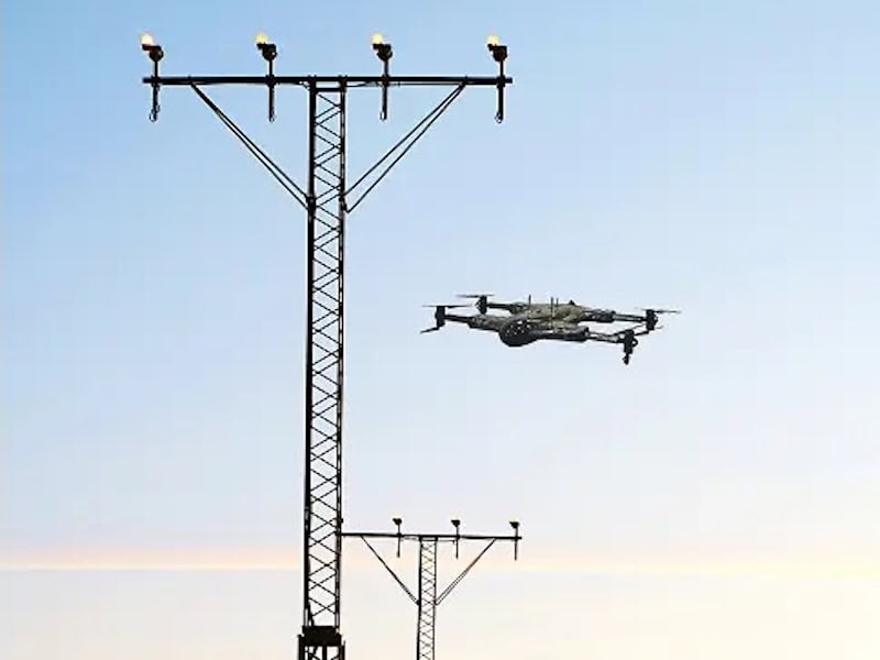
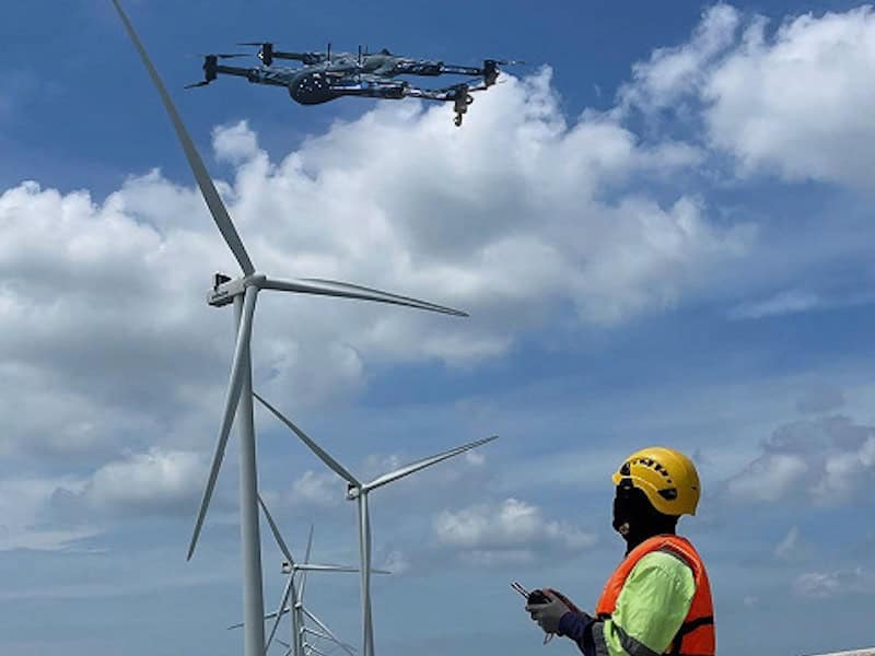
Drone as a Service (DaaS) is a leading provider of professional aerial data collection services that enable clients to unlock crucial insights across a wide variety of enterprise sectors. Powered by a network of companies owned by the ZenaTech Group, these end-to-end drone services encapsulate everything from mission planning through to deliverables.

Why Choose Drone as a Service?

Operating in a range of locations across the United States and Europe, the Drone as a Service (DaaS) team of experienced drone pilots and operators can scale up to meet your requirements over multiple project sites, timelines, and terrains.

  • Over 3500 clients served across a broad range of industries and market segments
  • More than 125 active projects surveyed weekly
  • 60% faster data delivery compared to traditional ground-based surveying methods
  • Up to 50% in cost savings through reduced manpower, time, and equipment usage

DaaS utilizes ZenaDrone‘s range of cutting-edge purpose-built autonomous drone platforms that can be equipped with advanced payloads and tailored to diverse project requirements.

Drone Services Offered

Land Surveying

Drone Land SurveysDrones are a force multiplier for land surveying, covering large areas in the fraction of the time that traditional methods require. DaaS utilizes autonomous platforms and advanced mapping and scanning technologies to carry out surveys efficiently and effectively, without the need to send personnel to operate manually on-site.

The land surveys deliver high-resolution imagery, elevation data, and 3D models with centimeter-level precision, and are ideal for site analysis, design planning, and monitoring land changes over time.

Construction Management

Drone Services for Construction ManagementDaaS drones allow engineers, architects, and construction personnel to gain a comprehensive bird’s-eye view of the work site and gather essential data that can be used for construction progress updates, project documentation, and monitoring.

High-accuracy measurements of elevations, distances, surfaces and volumes can be undertaken with minimal risk and downtime, allowing streamlined and cost-effective operations that comply with regulations.

Precision Agriculture

multispectral imaging for precision agricultureAgricultural professionals can take advantage of drone technology and multispectral imaging to monitor crop health, water levels, and pests and diseases. This crucial data allows them to optimize their management strategies and maximize crop yields, covering vast areas of farmland at a speed that would be impossible with traditional methods.

DaaS drone services can also be used to undertake a variety of other tasks such as crop spraying and seeding without needing to expose workers to potential chemical hazards.

Golf Course & Racecourse Management

Drone Services for Golf CoursesDaaS works with golf course and racecourse managers and groundkeepers to provide real-time insights and aerial intelligence for more effective management, maintenance and upkeep. By capturing the entire property from above, drones can provide data on turf health and irrigation levels, create accurate geo-referenced maps and 3D models for landscaping, and inspect track conditions for defects.

Drone services are also ideal for event management as well as for capturing broadcast-quality visuals for live filming, marketing and social media.

Drone 3D Scanning Services

3D Scanning Services

3D scanning via drone offers a more cost-effective and efficient way to capture the data required to create high-precision models of buildings, terrain, and landscapes for engineering, design, and project visualization.

Drone inspections for renewable energy industry

Renewable & Offshore Energy

Wind farms and hydroelectric facilities benefit hugely from drone inspections, which can quickly detect performance issues and structural defects that can lead to major downtime and loss of energy production.

Drone Terrain & Elevation Mapping

Terrain & Elevation Modeling

DaaS offers pay-per-project drone surveying services that generate centimeter-accurate terrain models and DEMs (digital elevation models), providing actionable insights for earthwork operations, change detection and monitoring, and infrastructure development.

multispectral drone imaging

Multispectral Terrain Mapping

Multispectral drone imaging provides data and insights from beyond the visible spectrum, supporting a wide variety of applications such as terrain mapping, plant health tracking, environmental monitoring, and underground water detection.

Solar Panel Drone Inspection

Solar Panel Drone Inspection

Drone thermal imaging services provide immediate return on investment for owners and operators of solar farms, identifying issues such as hotspots, microcracks, and bypass diode failures before they become larger problems.

drone inspections of power lines

Power Line Inspection

DaaS conducts safe and efficient drone-based inspections of power lines, detecting potential failures and encroaching vegetation and reducing outages without the risk of manual climbing or the expense of helicopters.

Urban Planning with Drones

Urban Planning

Drones are a crucial tool for urban planning and infrastructure design, capturing high-accuracy visual data and aerial views from multiple angles. This data can also be used to create sophisticated 3D models and digital twins.

Drones Services for Roof Inspection

Roof Inspection

Drone roof inspections provide an efficient method of damage assessment, condition monitoring and maintenance planning without the requirement for risky manual climbing.

Drone Concrete Scanning

Concrete Scanning

Drones equipped with laser scanners and ground-penetrating radar can be used to identify surface and subsurface defects and issues, as well as key features such as rebar, voids, post-tension cables, and electrical conduits.

Drone Solutions for Archaeology

Archaeology

Non-invasive drone mapping and scanning allows archaeologists to uncover, record, and preserve sites without disturbing the surroundings. High-definition 4K cameras, LiDAR, and multispectral sensors capture detailed imagery and video, 3D models, and features below the surface.

Products

Land Surveying

High-accuracy drone surveying services for property mapping & land development

Construction Management

Track construction progress and document projects

Golf Course & Racecourse Management

Drone services for grounds management, events and marketing

Precision Agriculture

Drone-based aerial analytics for optimized management and increased yields

3D Scanning Services

High-accuracy drone 3D scans of buildings, terrain & landscapes

Archaeology

Non-invasive drone-based recording & preservation of archaeological sites

Urban Planning

Drone-gathered high-resolution imagery and data for city planning & infrastructure design

Multispectral Terrain Mapping

Multispectral drone imaging for plant health analysis & environmental monitoring

Terrain & Elevation Modeling

Precision mapping & modelling for civil engineering & land development

Concrete Scanning

Precision drone scanning for detection of defects and features

Solar Panel Drone Inspection

Drone-based thermal imaging for solar panel analysis & fault detection

Power Line Inspection

Drone inspection services for power line fault detection

Roof Inspection

Efficient roof surveying for damage assessment and maintenance planning

Renewable & Offshore Energy

Inspection services for wind farms and hydroelectric facilities

Articles

Latest
When Professional Drone 3D Scanning Services Are Required

Drone as a Service by ZenaDrone examines when professional drone 3D scanning services are required, covering accuracy validation, survey workflows, project risk, and applications requiring verified spatial data

Jun 09, 2026
Construction Site Drone 3D Scanning for Progress Tracking & Quantity Measurement

Drone as a Service by ZenaDrone examines how aerial 3D scanning improves construction progress tracking, quantity verification, and site accuracy through photogrammetry, LiDAR, and survey-grade data collection

May 29, 2026
Drone Enabled Inspection & Monitoring for Renewable Energy Infrastructure

Drone as a Service by ZenaDrone outlines how drone-based inspection improves safety, reduces downtime, and enhances monitoring across large-scale renewable energy infrastructure

Apr 30, 2026
Drone Data Analytics Enhances Renewable Energy Operations

Drone-as-a-Service by ZenaDrone outlines how drone data analytics transforms aerial data into actionable insights, enabling predictive maintenance, improved safety, and greater operational efficiency across renewable energy assets

Apr 08, 2026
Drone-Based Aerial Data Collection Services for Professional & Enterprise Applications

Drone as a Service's end-to-end offerings are highly scalable and can be tailored to suit a wide range of project requirements

Mar 25, 2026
Nano Drone Launched for Indoor & Warehouse Use

ZenaTech’s new IQ Nano Drone is designed for indoor use in warehouse, distribution, and plant facilities for inspection, monitoring, and tracking processes like inventory management

Oct 29, 2024
ZenaDrone Signs Agreement with USNRL to Advance UAS Technology

The Cooperative Research and Development Agreement (CRADA) will help leverage both organizations' strengths, potentially revolutionizing drone technology applications, and will enable the testing of ZenaDrone 1000 with U.S. Navy operations

Feb 09, 2024
VTOL Multirotor Drone Deployment to Ireland

The drone will support farmers with monitoring plant health and spraying weeds and the police and fire departments as an integrated part of the first-responder system in times of emergencies

Jul 13, 2023
Regional Offices & Locations
Drone Services in Florida United States of America Florida +1(888) 593-6223 Contact Contact Website
Drone Services in Virginia United States of America Virginia +1(888) 593-6223 Contact Website
Drone Services in Oregon United States of America Tigard, Oregon +1(888) 593-6223 Contact Website
Drone Services in Arizona United States of America Tucson, Arizona +1(520) 790-8373 Contact Website
Drone Services in California United States of America Santa Rosa, California +1 707-575-3427 Contact Website
Drone Services in South Carolina United States of America Rock Hill, South Carolina +1(888) 593-6223 Contact Website
Drone Services in North Carolina United States of America Greensboro, North Carolina +1 336-272-8922 Contact Website
Drone Services in Nova Scotia Canada Halifax, Nova Scotia +1(888) 593-6223 Contact Website
Drone Services in Ireland Ireland Dunboyne, Co. Meath +353 1 727 0171 Contact Website
Drone Services in the UK United Kingdom Weston Super Mare +44 1934 300615 Contact Website
Advancing Unmanned Systems Through Strategic Collaboration UST works with major OEMs to foster collaboration and increase engagement with SMEs, to accelerate innovation and drive unmanned systems capabilities forward.