


Discover World-Leading Unmanned and Autonomous Technologies
Discover cutting-edge solutions from leading global suppliers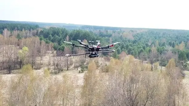
Routescene has announced that its UAV (unmanned aerial vehicle) LiDAR technology has been used by a team of multidisciplinary researchers to perform detailed mapping of radiation hotspots in and around the Chernobyl nuclear power plant in Ukraine.
The team from the UK’s National Centre for Nuclear Robotics (NCNR) conducted surveys on multiple sites of interest within the Exclusion Zone which surrounds the damaged reactor. These sites included the abandoned village of Buriakivka and the “Red Forest”, a natural woodland area located the closest to the reactor.
The team had selected Routescene’s lightweight LidarPod and a DJI M600 hexacopter drone to perform radiation mapping surveys. The resulting point cloud data was processed using Routescene’s LidarViewer Pro software to generate a detailed Digital Terrain Model (DTM), which was then overlaid with the radiation intensity results from a gamma spectrometer survey to locate the exact sites of the radiation hotspots.
Multiple missions were flown over the selected sites over the course of ten days, resulting in the most detailed map of radiation in the forest to date. The data also revealed radiation anomalies at previously unsuspected locations. While the general widespread radiation contamination in the Red Forest was already known, the results revealed that although radiation intensity had reduced in some areas, other areas remain highly contaminated and thus dangerous to enter.
Routescene’s LidarPod is made up of an array of high-resolution survey-grade sensors, collecting up to 1.4 million data points per second from 32 different lasers angled in a 40-degree field of view. This Routescene solution enabled the researchers to conduct operations and complete real-time QA monitoring at a safe distance from the radioactive sites.
Dr Kieran Wood, Senior Research Associate at the University of Bristol, commented: “The team required high-resolution terrain and building models as inputs to a hotspot identification algorithm. It was also very useful to capture the 3D shape of some buildings.”
“The algorithm converts the aerial radiation intensity recorded by a UAV survey into a ground intensity map. This process is heavily affected by the distance between the airborne radiation sensor and the ground/buildings. Hence high accuracy LiDAR based models were essential.”
This recent expedition to the Red Forest was the first in a planned series of surveys to be conducted by NCNR in Ukraine. The new maps generated by these surveys will help officials prevent risks to visitors to the area, and the full results will be published in the near future.
Find manufacturers of LiDAR for unmanned and autonomous applications >>


