


Discover World-Leading Unmanned and Autonomous Technologies
Discover cutting-edge solutions from leading global suppliers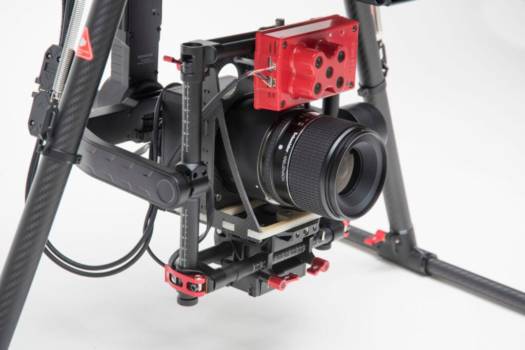
Phase One discusses the use of the Phase One Industrial 100MP camera to provide precision aerial imagery for agricultural phenotype research.

Overview
Aerial Drone Data Collection
The University of Saskatchewan Plant Sciences team conducts extensive agricultural phenotype research and requires precision imagery for digital phenotyping and genomics for crop breeding. In 2018, Draganfly and the Plant Sciences team sought a new solution with higher resolution images to help achieve more actionable insights.
Digitally Documenting Crop Characteristics
Scientists leverage precise digital phenotyping and genomics while using drones to image crops, essentially photocopying fields, to better document and understand crop characteristics. With digital collection, phenotypers can quantify their observations and run images through Convolutional Neural Networks (CNNs) to more rapidly identify changes and trends that may not have been easy for researchers to identify in the past.
20x More Efficient
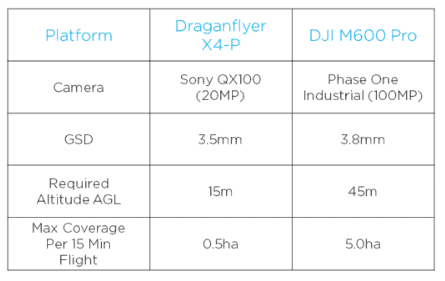
When directly comparing flights to collect color imagery with a GSD of less than 4mm, Phase One Industrial cameras are able to provide approximately 10 times more land coverage per 15-minute flight.
To image a quarter section of land (160 acres or 65ha) at <4mm GSD, it would take approximately 10 flights with the M600 and Phase One setup, while the previously used Draganflyer X4-P and Sony QX100 would require approximately 100 flights. Because of the efficiency of imaging with two cameras simultaneously, the number of flights required has been further reduced, resulting in 20 times more data collected for the equivalent flight duration.
Solution
Improving Data Collection with High-Resolution Imagery
The medium-format camera was integrated alongside the multispectral sensor onto the DJI platform, operated by the Draganfly Surveyor mission planning software. Design and fabrication of mounting components were required to make both cameras fit on the gimbal together. Although the physical installation was fairly straightforward, the team was challenged in the communication between the UAV operating system and both cameras side-by-side. Phase One Industrial cameras automatically integrate with the DJI M600 UAV, however, customized operating hardware and software development was required in order to trigger both cameras simultaneously.
A purpose-built interface circuit board was designed and software was written to act as a bridge between the DJI A3 Pro autopilot, each of the cameras, and the Draganfly Surveyor mission planning software. In flight, the A3 Pro autopilot runs the automated flight plan and sends camera control and shutter commands through the same interface circuitry to simultaneously trigger the cameras at the correct time. With the custom integration completed, the development team realized a significant improvement in both productivity and image quality when compared to previous data collection methods.
“The Phase One camera is really easy to use. All the information needed to operate and integrate the camera is provided. The level of detail in the integration guide and technical documents far exceeds what we have seen from other camera manufacturers.” Cory Barker, Dragonfly Innovations Product Manager.

Phase One Aerial System
The fully integrated Phase One drone solution contains:
- Phase One iXM-100 Aerial Camera
- 150mm RSM lens
- DJI M600 PRO drone
- Phase One iX Capture Mobile Application
The customized solution includes:
- MicaSense RedEdge 3
- Purpose-built interface circuit board and software to act as a bridge between the DJI A3 Pro autopilot, each of the cameras, and the Draganfly Surveyor mission planning software
The system offers a cost-effective measurement of small-scale areas with millimeter accuracy. The motorized RSM lens offers the flexibility to fly the UAV at higher altitudes, if needed.


