


GNSS/INS (GNSS-Aided INS)
Discover cutting-edge solutions from 10 leading global suppliers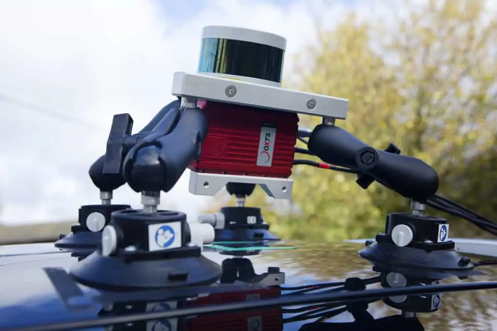
OxTS has conducted a Q&A interview for Velodyne LiDAR that provides information on how combining LiDAR with GNSS/INS technology can provide accurate and consistent position, orientation and heading and thus improved measurements. OxTS is an experienced developer of GNSS-aided inertial navigation solutions for mapping and surveying, and its products are ideal for UAV (unmanned aerial vehicle) and UGV (unmanned ground vehicle) platforms.
The responses were authored by Paris Austin, Lidar Survey Business Manager at OxTS.
Q: Why should companies pair an Inertial Navigation System with 3D lidar – how do the technologies complement each other?
Paris: In my mind, pairing these two technologies creates a perfect combination that shares their strengths and offers completely mutually exclusive features. Lidar provides an external sensing method and answers the question “how far away is that object to my left?” This information gives you range and angle to the target which is entirely relative to the lidar’s current location. As soon as the lidar moves or rotates, that historic measurement is no longer valid unless you have a reference for where it was when it took that measurement. Inertial Navigation Systems offer that information for 3D position and orientation and they offer it with an absolute coordinate system reference – the Earth. This paired with nanosecond accurate time synchronization (thanks to GNSS) means the lidar data can go from being valuable in an instantaneous way to being valuable in a perpetual way.
Q: What are some of the solution areas where INS and lidar can be applied together?
Paris: Any survey and mapping application that uses lidar can benefit from an INS. Particularly long baseline work such as UAV pipeline inspections or land-based highway scanning which can be limited by the distance of the survey area to be covered. We produced a case study of a baseline survey project we did with a drone manufacturing company Dronezone SRL. They combined an OxTS xNAV INS with a Velodyne Puck sensor to survey a 40km stretch of road. The case study explains in detail how an INS can really aid long baseline surveys.
The INS removes the need for ground control points and does not drift in position as you get farther away from your starting point. This makes it instantly usable when comparing results to existing maps in the global coordinate frame. Other high accuracy requirement applications that require repeatable and accurate results – like asset management survey in a fixed area – will benefit from the absolute repeatability of an INS. The pure speed at which data can be collected versus static survey applications unlocks a huge amount of potential for the future scalability of this technology.
Q: How can INS and lidar data be combined and what benefits does that combination provide?
Paris: Initially time synchronization between the sensors is the major focus. Getting accurate timestamped data means your navigation data is as relevant to each lidar scan as absolutely possible. Once the two sensors are synchronized, each lidar scan that is logged is georeferenced based on the INS’ position and orientation during each laser firing batch. The outcome is a 3D point cloud, and the benefit is highlighted through a lack of drift over time and distance from the start. The benefit to users is accuracy on all objects within that point cloud, allowing them to make intelligent decisions based on the data, which we believe they can trust.
Q: Why did OxTS join the Automated with Velodyne program? How do you see being part of the AwV ecosystem benefiting your company?
Paris: Joining Automated with Velodyne aligned perfectly with our plans as a team at OxTS. We believe that strong complementary partnerships with technology providers like Velodyne will help us to provide our customers with better solutions to their requirements. Another benefit we see is that collaborating encourages more exposure in the market and so adoption of these technologies within the industry will increase. Everything is about helping our existing and new customers to have confidence that OxTS products will deliver solutions to their applications. We can also provide quality content like in-depth support guides for the Velodyne products, as well as joint webinars, which is exactly the approach we want to take.
To find out more about the relationship between lidar sensors and Inertial Navigation Systems, and how these technologies play a vital role in 3D point clouds, watch the replay of a webinar conducted by OxTS and Velodyne LiDAR below.


