


Discover World-Leading Unmanned and Autonomous Technologies
Discover cutting-edge solutions from leading global suppliers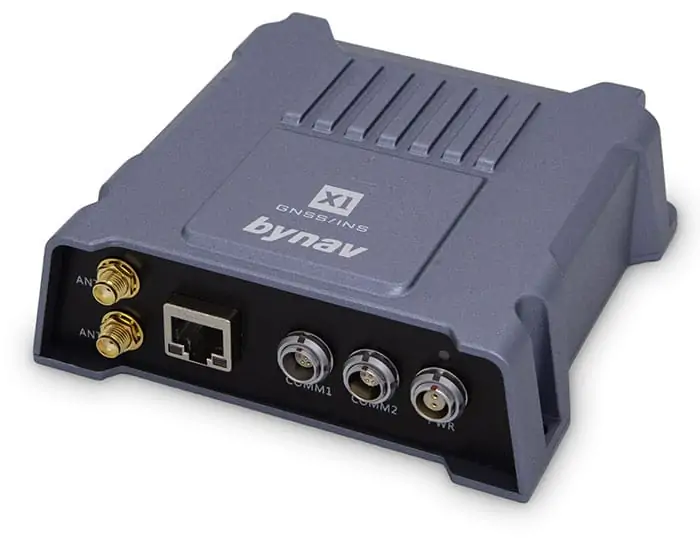
Bynav, a leading developer of high-precision GNSS and GPS RTK positioning and navigation solutions for unmanned systems, has partnered with Unmanned Systems Technology (“UST”) to demonstrate their expertise in this field. The ‘Gold’ profile highlights how their products can be used for demanding unmanned and autonomous applications on land, at sea and in the air, including UAVs (unmanned aerial vehicles), UGVs (unmanned ground vehicles) and USVs (unmanned surface vessels).
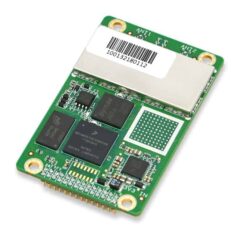 The C1 family of OEM GPS and GNSS receiver boards provides high-precision heading and RTK positioning capabilities. Covering all constellations, with eight-frequency or full-frequency options, the C1 range features both single- and dual-antenna models.
The lightweight, compact boards provide enhanced multipath mitigation, anti-interference and anti-blockage performance, and can be deeply coupled with an inertial navigation system. Communication options include serial, CAN and Ethernet.
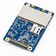
 The A1-3L is an OEM GNSS/INS board featuring a tactical grade IMU deeply coupled with a dual-antenna multi-frequency all-constellation GNSS receiver. Providing RTK positioning and heading capabilities, it is ideal for reliable navigation in challenging environments such as urban canyons and GPS-denied regions.
The compact and lightweight board outputs IMU and INS data at a rate of up to 50 Hz and provides a range of connection options including serial, Ethernet and CAN. Raw data can be output for post-processing.
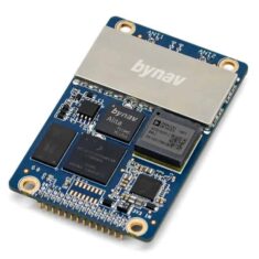
 The A1-3H OEM GNSS/INS board tightly couples a tactical-grade IMU with a dual-antenna GNSS receiver supporting all constellations and all frequencies, providing a future-proof high-accuracy navigation solution for drones and robotics. With RTK positioning and heading capabilities, it is ideal for operation in urban canyons and GPS-denied regions, and also supports external odometers and LiDAR scanners for visual SLAM (simultaneous localization and mapping).
The compact and lightweight board outputs IMU and INS data at a rate of up to 100 Hz and provides a range of connection options including serial, Ethernet and CAN. Raw data can be output for post-processing.
 The X1-3 is a rugged GNSS-aided INS enclosure that tightly couples high-stability gyro and accelerometer measurements with accurate GNSS positioning data to provide real-time navigation for unmanned systems and robots in all domains. The all-constellation, multi-frequency RTK-capable system can provide post-processed results accuracy of 0.01m for horizontal position, 0.02 m/s for horizontal velocity and 0.012 degrees for roll/pitch.
The enclosure provides a range of connection options, including serial, CAN and Ethernet. External sensors such as LiDAR scanners, cameras and odometers can be easily interfaced.

With a range of connection options including serial, CAN and Ethernet, the X1-5 allows easy integration of external sensors such as LiDAR scanners, cameras and odometers. The system is ideal for a wide variety of unmanned systems applications such as mapping and surveying, precision agriculture and autonomous driving.

External sensors such as LiDAR scanners, cameras and odometers can be easily integrated into the X1-6, facilitating a variety of high-precision navigation applications such as self-driving vehicles and SLAM (simultaneous localization and mapping).
The system’s multipath suppression technologies make it ideal for integration into robotic systems operating in urban environments and built-up areas. Signal quality and tracking loop performance can be monitored in real time.
The system is highly programmable, with a low-pass filter that supports a range of bandwidth configurations with either analogue or digital output.


