Teledyne CARIS’ Mira AI cloud platform and CARIS Onboard software have been used to enable onboard autonomous survey and real-time processing capabilities for an unmanned surface vessel (USV) that mapped over 1000 square kilometres of the Atlantic Ocean floor in 22 days. The vessel, built by SEA-KIT and operated remotely by the GEBCO-Nippon Foundation Alumni Team, was continuously monitored via satellite communications at its Remote Operations Center in Essex, United Kingdom.
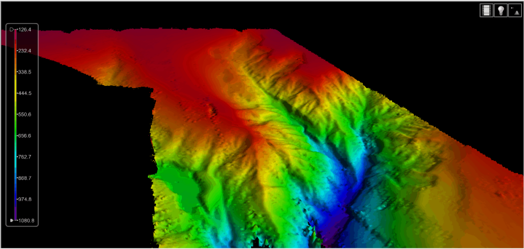
The aim of the mission was to survey a largely uncharted area at the southwestern edge of the UK Continental shelf. The image below shows the initial results following a fully automated processing workflow. Final processing of the data to produce the finished deliverable is still being undertaken, using CARIS’ HIPS hydrographic data processing system.
The survey was undertaken as part of the Uncrewed Trans-Atlantic Survey (UTAS) Project, and demonstrated the capabilities of Teledyne CARIS’ software solutions to support uncrewed surveys in the future, including during The Nippon Foundation-GEBCO Seabed 2030 project. Seabed 2030 is an ambitious effort between GEBCO and The Nippon Foundation to complete the global mapping of the ocean floors in the next 10 years.
Andy Hoggarth, VP of Sales and Marketing at Teledyne CARIS, commented: “Teledyne CARIS is uniquely positioned to underpin Seabed 2030 goals through its AI capabilities, web services and automated data processing workflows. The success of this first leg is a tribute to the strong leadership of SEA-KIT and the unique capabilities and insights of all of the member organizations— we are delighted to play a part in this mission.”


