Scalable UAV Image Collection and Processing Solution Unveiled

By Mike Ball / 23 Jul 2020
Follow UST

WingtraOne mapping drone

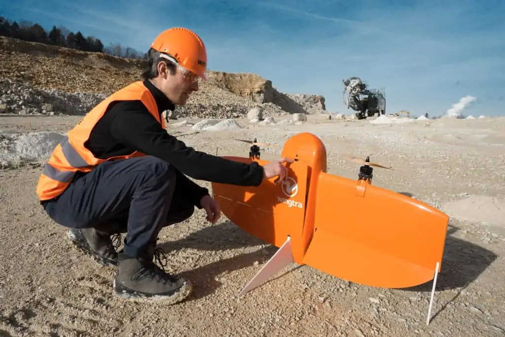
PCI Geomatics and Wingtra have teamed up to provide a flexible and scalable UAV (unmanned aerial vehicle) image collection and processing solution utilising the WingtraOne VTOL fixed-wing drone and Geomatica image analysis software.

To find out more about the Wingtra-One-Geomatica bundle, read this case study on PCI Geomatics’ website

The combined solution allows capturing of one-centimetre imagery and generation of one-centimetre DSMs (digital surface models). This 1:1 resolution DSM generation, along with Geomatica’s innovative editing tools, eliminates artifacts commonly seen in UAV imagery datasets in areas such as trees, water and building edges.

The Wingtra-Geomatica bundle also allows users to automatically make use of ground control points (GCPs), with the option to set them manually for the first aerial survey and use the resulting ortho-mosaic for automatic ground control collection thereafter. Existing ortho-mosaics can also be used to automatically collect and apply GCPs. This process reduces manual labour, and increases the quality and consistency of results for repeat surveys of the same area.

PCI Geomatics offers scalable technology that allows users to efficiently process large volumes of imagery and keep up with any level of demand and projects of any size. According to the company, this efficient processing is among the fastest on the market based on internal benchmark results.

Kevin Jones, Executive Director of Marketing at PCI Geomatics​, commented: “The UAV market has evolved over a short period of time, with professional users looking to source efficient platforms to collect imagery, coupled with efficient processing software that provides the needed tools for editing and producing high quality DSMs and ortho-mosaics.”

“Wingtra provides the perfect solution for collection through its unique and proven VTOL technology. Geomatica provides automation, scalability, live editing, and a host of additional tools to extract information from UAV imagery and perform analysis.”

Posted by Mike Ball Mike Ball is our resident technical editor here at Unmanned Systems Technology. Combining his passion for teaching, advanced engineering and all things unmanned, Mike keeps a watchful eye over everything related to the unmanned technical sector. With over 10 years’ experience in the unmanned field and a degree in engineering, Mike’s been heading up our technical team here for the last 8 years. Connect & Contact

Latest Articles

Most Read Articles on UST This Week

Here’s our round-up of the five most read articles on UnmannedSystemsTechnology.com this week

Jan 18, 2025
New High-Precision VTOL UAV LiDAR Scanning Solution

Ventus-Tech Robotics' tailsitter VTOL UAV has been integrated with the Yellowscan Mapper+ OEM payload

Jan 17, 2025
Controller Software Enables Pre-Programmed Precision Composite Curing

UAVOS is developing the Controller Software for its Composite Curing Ovens, providing a pre-programmed mode to optimize curing technology precise and efficient processes

Jan 17, 2025
New Connectors & Terminals Released for Drone Applications

ETCO Incorporated has introduced a new range of connectors and terminals for drone operations, provided in a variety of materials and designs

Jan 17, 2025
Autonomous Inland Navigation to Display at XPONENTIAL Europe

Research institute DST will bring its autonomous inland navigation capabilities to XPONENTIAL Europe with ELLA, a pioneering autonomously cruising research vessel

Jan 17, 2025
Choosing the Right Ethernet Switch for GigE Vision Cameras

Explore BotBlox's Ethernet switches for GigE Vision cameras, comparing their suitability for high-performance streaming in drones and embedded platforms

Jan 17, 2025

Featured Content

“Surveillance as a Service” UAV Solution Launched

Volatus Aerospace’s “Surveillance as a Service" solution will use drone technology to provide secure, multi-modal surveillance for faster response times and actionable intelligence

Jan 16, 2025
Aurora & SkyGrid Advance Airspace Management Solutions for UAVs

Aurora Flight Sciences and SkyGrid are set to enhance Advanced Air Mobility (AAM) by collaborating on systems for integrating UAVs into the national airspace

Jan 14, 2025
New Safety System Unveiled for Anzu Raptor Drones

ParaZero has launched the SafeAir Raptor, a parachute safety system for Anzu Robotics’ Raptor and Raptor T drone models that complies with ASTM F3322-22 standards

Jan 08, 2025
How ANELLO’s Disruptive SiPhOG™ Technology is Shaping the Future of Precision Navigation

UST sits down with Dr. Mario Paniccia, CEO at ANELLO Photonics, to learn how Silicon Photonics Optical Gyroscope technology is empowering autonomous systems with cutting-edge navigation solutions

Jan 06, 2025
XPONENTIAL Europe Highlights Autonomous Robotics for Perimeter Security

XPONENTIAL Europe, held in Düsseldorf from 18-20 February 2025, will focus on uncrewed systems and highlight their use for protecting critical infrastructure

Jan 02, 2025
Software-Defined Networking Capability Selected for Attritable Autonomous Systems

Viasat will provide its NetAgility SDN system in support of the US DoD's Replicator initiative

Dec 24, 2024