Drones Used to Predict Flash Flooding in Alaska

By Mike Ball / 25 May 2020

Smart Sourcing for Unmanned Systems

Discover cutting-edge solutions from leading global suppliers
SUPPLIER SPOTLIGHT
Follow UST

WingtraOne drone

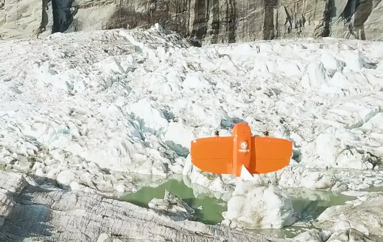
A climate research team from the University of Alaska Fairbanks Climate Adaptation Science Center has used drones to track the rising and falling of ice and water levels in the Suicide Basin glacial lake near Juneau, Alaska. The project will allow the team to predict the glacial lake’s seasonal flux and help protect neighboring communities from sizable flash floods.

A fixed-wing drone manufactured by Wingtra has been used to gather data for the creation of orthophotos and digital elevation models. The WingtraOne UAV (unmanned aerial vehicle) features multi-frequency PPK capability for high levels of location accuracy without the need for extensive ground control.

The research team is studying how water interacts with the Mendenhall Glacier, which sits next to the basin and holds it together. Mendenhall was once connected to Suicide Glacier before rising temperatures separated them, resulting in Suicide Basin. When basin waters rise to a point, Mendenhall Glacier can no longer contain them and the entire basin drains, immediately causing flash floods.

The flash floods in the Suicide Basin began in 2011, and have damaged infrastructure in the valley several times. The orthophotos and digital elevation models from the drone data allow the team to assess changes to ice levels atop Suicide Basin, and track the water level and interactions with the Mendenhall glacier.

Gabriel Wolken, head of the research team, commented: “The main issue is that it’s ice covered so we can’t really see the water as it fills up the basin on a seasonal basis. Alaska is a big place. There’s virtually nothing we address that we consider small here. So if it’s going to be a drone, we have to have something that can actually fly for a long time, fly high enough to be able to handle the complex terrain that we’re constantly dealing with and provide the resolution that’s required for the analyses that we’re doing.”

“The WingtraOne drone covers a large area, efficiently and provides data that is high quality in terms of visualization and location accuracy.”

“This flooding potentially threatens a bridge that is connected to the road system. And this is the only road that would connect residents on the north side to hospitals and other vital facilities, so if this bridge was impacted it would cause some very serious issues for a lot of people.”

To find out more about the project and the WingtraOne drone, read this case study on Wingtra’s website.

Find manufacturers of Fixed Wing Drones >>

Posted by Mike Ball Mike Ball is our resident technical editor here at Unmanned Systems Technology. Combining his passion for teaching, advanced engineering and all things unmanned, Mike keeps a watchful eye over everything related to the unmanned technical sector. With over 10 years’ experience in the unmanned field and a degree in engineering, Mike’s been heading up our technical team here for the last 8 years. Connect & Contact

Latest Articles

Who to see at Xponential 2025

UnmannedSystemsTechnology.com are thrilled to be working with so many companies attending AUVSI's Xponential this year...

May 12, 2025
GuideNav: Top MEMS IMUs for UAV Flight Control

GuideNav examines MEMS IMU selection for UAV control, comparing accuracy bands and performance levels across consumer, industrial, and military-grade applications

May 12, 2025
Aurora Flight Sciences Advances sUAS Range with New Upgrades

Aurora Flight Sciences has enhanced its SKIRON-X sUAS range to improve flight performance and simplify operation

May 12, 2025
ATL Fuel Bladders for Unmanned Systems to Feature at XPO25

Aero Tec Laboratories (ATL) will present its latest fuel bladder technologies for unmanned systems at XPONENTIAL 2025, highlighting solutions for air, land, and sea

May 12, 2025
uAvionix Unveils Wearable ADS-B Receiver for UAS Operations

uAvionix announces skyAlert, a rugged, wearable ADS-B receiver purpose-built for professional UAS pilots and their visual observers

May 12, 2025
ParaZero Secures European Order for Drone Parachute Safety System

ParaZero receives a significant European order for its SafeAir™ M4 system, highlighting rising demand for advanced drone safety solutions in high-regulation markets

May 12, 2025

Featured Content

New Tactical Grade IMU from Inertial Labs for UAVs & Guided Munitions

Inertial Labs has launched the IMU-H100, a compact, tactical-grade MEMS IMU designed to enhance precision navigation for UAVs and guided systems

May 08, 2025
Geolocation in GPS-Denied Environments Successfully Demonstrated

Trillium Engineering's GD-Loc, integrated with the HD55-MV gimbal on a Group 2 UAS, has successfully demonstrated sustained Category 1 geolocation accuracy within six meters, highlighting its critical advantage for precise ISR missions in GPS-denied environments

May 06, 2025
Spexi + LayerDrone: A New Era of Aerial Intelligence

Imagine a real-time, crowd-sourced map of Earth. Spexi, powered by LayerDrone, pays drone pilots to capture ultra-detailed imagery, offering organizations data that’s faster, cheaper, and more precise than traditional methods

Apr 29, 2025
Advancing Unmanned Systems Through Strategic Collaboration UST works with major OEMs to foster collaboration and increase engagement with SMEs, to accelerate innovation and drive unmanned systems capabilities forward.