


Discover World-Leading Unmanned and Autonomous Technologies
Discover cutting-edge solutions from leading global suppliers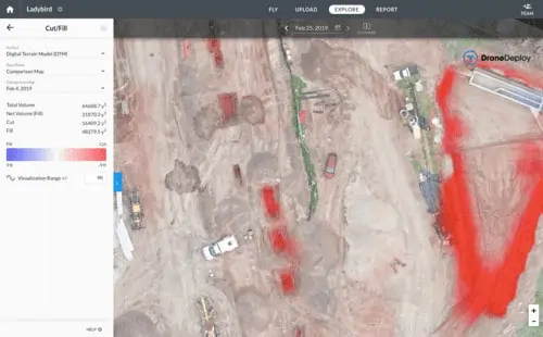
DroneDeploy, an enterprise-grade drone data platform, has announced a major expansion across its products, making it a single platform for all drone operations. The launch includes automated drone fleet management, enhanced workflow integrations, a low-altitude inspection mode, and advanced analytic capabilities.
“Today’s product launch is a reflection of the demand from our customers for a complete enterprise-grade drone operating system,” said DroneDeploy Chief Executive Officer and co-founder Mike Winn. “We have customers with fleets of 100+ drones looking for a single enterprise platform for their entire drone program, and we believe this launch will reshape how they manage their drone operations and data.”
DroneDeploy’s new product release includes:
- Drone Operations Management: Record all flight activity automatically, in one platform, providing full visibility of your entire drone program, including highlighted flight settings, maximum altitude, and speed.
- Workflow Integrations: Customers can now sync DroneDeploy with their preferred document storage or project management applications, including Autodesk, Procore, Bluebeam, Plangrid, and OneDrive.
- Inspection with Manual Flight: Customers can now fly in manual mode, allowing the flexibility to explore however they wish, including low-altitude inspections and custom photos and videos.
- Drone Academy: DroneDeploy Academy is a comprehensive training program focused on teaching the basics of drone operations while offering insight into the business impact of drones.
- Earthworks: With advanced cut & fill capabilities and new 3D analytics, customers can now quantify the amount of earth moved in a matter of hours rather than days, helping to avoid delays and cost overruns.
“With DroneDeploy’s Earthworks capabilities, I have the confidence I am providing my engineers with accurate information in surveying, tracking progress, and verifying contractor work,” said Greg Oetker, an Inspector at Jones Carter. “I am able to use a map and model to help visualize the site, which makes planning more efficient and accurate. This new way of surveying has saved us hours of time each time we go out and capture data.”


