AUV Exploration Mission Finds WW2 Submarine

By Mike Ball / 30 Jul 2019

Smart Sourcing for Unmanned Systems

Discover cutting-edge solutions from leading global suppliers
SUPPLIER SPOTLIGHT
Follow UST

AUV ocean exploration submarine discovery

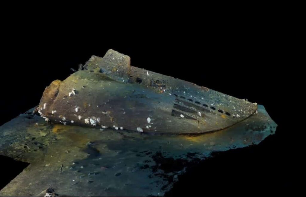
A team pioneering robotic ocean exploration has announced that it has found the bow of WWII Submarine USS Grunion (SS-216) in 2700 feet of water off the Aleutian Islands, Alaska. The ongoing WWII submarine discoveries lead by ocean explorer Tim Taylor are applying comprehensive 3D imaging to further subsea exploration.

The discovery was made utilizing a combination of autonomous underwater vehicles (AUVs) and advanced photogrammetry imaging. The finding of the lost bow section of the USS Grunion completes a vital missing part of the puzzle and answers the questions posed on many expeditions undertaken 13 years ago by the sons of the USS Grunion’s captain, Mannert L. Abele. Taylor stated, “I am honored to add to the discovery that was accomplished by the Abele brothers.”

USS Grunion was a Gato-class submarine commissioned on April 11, 1942 under the command of Lieutenant Commander Mannert L. Abele. On her way through the Caribbean to her first posting in Pearl Harbor, she rescued 16 survivors from USAT Jack, which had been torpedoed by a U-boat. Sent to the Aleutian Islands in June 1942, she operated off Kiska, Alaska, where she sank two Japanese patrol boats. Ordered back to the naval operating base in Dutch Harbor, Alaska, on July 30th, the submarine was never heard from again. She was declared overdue from patrol and assumed lost with all hands-on October 5th, 1942.

The project is taking the large data sets collected on the team’s discoveries and having them processed into 3D archaeological photogrammetry models. This scientific approach extracts geometric information from equipment that is already integrated in most of the modern underwater remote filming systems, advancing imagery collection into high-quality 3D data sets that will be used in archaeological research, historical archives, virtual and augmented reality, and educational programs and applications.

“This goes so far past video or still imagery, it truly is the future of recording historical underwater discoveries. Spending minimal time on site collecting a comprehensive 3D historical baseline model allows archaeologists and historians to spend months back home performing detailed research,” commented Taylor. who coordinates his discoveries with the Naval History and Heritage Command.

“Our mission at the Naval History and Heritage Command is to make certain the memory of our Sailors’ service will always be remembered, honored and valued. As Tim Taylor, and others like him, discover the final resting place for our lost Sailors, they help to carry out that mission,” said Robert S. Neyland, Naval History and Heritage Command’s Underwater Archaeology Branch Head. “We are grateful for the respectful, non-intrusive work he performs and the closure he brings to their families, their shipmates, and to the Navy.”

The USS Grunion expedition is part of the ongoing “Lost 52 Project” supported in part by STEP Ventures and has been recognized by JAMSTEC (Japan Agency for Marine-Earth Science and Technology) as the first and most comprehensive offshore underwater archaeological expedition in Japanese waters.

Posted by Mike Ball Mike Ball is our resident technical editor here at Unmanned Systems Technology. Combining his passion for teaching, advanced engineering and all things unmanned, Mike keeps a watchful eye over everything related to the unmanned technical sector. With over 10 years’ experience in the unmanned field and a degree in engineering, Mike’s been heading up our technical team here for the last 8 years. Connect & Contact

Latest Articles

SightLine Software & Hardware Advancements for Enhanced ISR Applications

SightLine Applications LLC introduces the 3.9.2 update, enhancing the 4100 video processor and unveiling the ultra-compact 1710 processor for advanced ISR applications

Jul 16, 2025
Silicon Sensing’s MEMS Technology Enhances Vehicle Localization for Autonomous Driving

The University of Toronto investigated approaches to determining spatial awareness in autonomous vehicles, with Silicon Sensing's DMU41 IMU succeeding in cost-effectiveness, reliability and accuracy

Jul 16, 2025
CHC Navigation Launches AU20 MMS for Precision LiDAR Mapping of Infrastructure

CHC Navigation (CHCNAV) has unveiled the AU20 MMS, a vehicle-mounted mobile mapping system designed for accurate and efficient collection of 3D spatial data

Jul 16, 2025
ZIYAN to Highlight UAV Coordination & Unmanned Helicopter Solutions at IDEF 2025

ZIYAN Tech will unveil its latest combat UAV technologies at IDEF 2025, highlighting advanced swarm coordination, ISR systems, and unmanned helicopter capabilities

Jul 16, 2025
Boosting First Responder Drones with Advanced BVLOS Technology

DroneSense and MatrixSpace partner to enhance BVLOS capabilities, accelerating the safe, scalable use of drones in public safety and Drone as First Responder missions

Jul 16, 2025
TEKEVER Advancing Defense & Civil Security Drones with Cahors Centre of Excellence

Tekever will establish a new dual-use Centre of Excellence in Cahors, France to develop, test, integrate and industrialize autonomous defense and security technologies

Jul 16, 2025

Featured Content

SBG Systems Evaluates INS Performance in GNSS-Denied Marine Applications

SBG Systems evaluates the performance of its INS solutions in GNSS-denied marine environments, comparing system accuracy with and without DVL and warm-up support

Jul 14, 2025
USAF Uses Inertial Labs Drone Lidar for Tree Obstruction Survey

The US Air Force successfully used Inertial Labs drone Lidar and cloud software to quickly map tree obstructions at Joint Base Lewis-McChord (JBLM), improving airfield safety

Jul 11, 2025
New UAV to Combine Solar Hydrogen & Battery Power for Extended Flight

XSun and H3 Dynamics are developing the first UAV powered by solar, hydrogen, and batteries, aiming to deliver zero-emission, long-endurance unmanned flight

Jul 07, 2025
Advancing Unmanned Systems Through Strategic Collaboration UST works with major OEMs to foster collaboration and increase engagement with SMEs, to accelerate innovation and drive unmanned systems capabilities forward.