3D HD Integrated Mapping & Surveying Solution Unveiled for UAVs

By Mike Ball / 28 Apr 2019

Mapping Drones

Discover cutting-edge solutions from 20 leading global suppliers
SUPPLIER SPOTLIGHT
Follow UST

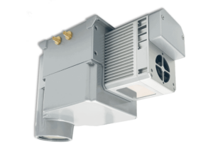
Polynesian Exploration PolyScannerPolynesian Exploration has announced the release of PolyScanner, a high-performance, compact integrated solution for unmanned aerial vehicle (UAV) 3D HD mapping and surveying.

The system features dual frequency dual antenna GNSS INS, a high level of integration and a compact, robust design. The next generation long-range LiDAR and industry-grade global shutter camera provide superior performance in comparison with rolling shutter cameras commonly used in mapping and GIS equipment. The PolyScanner system is supported by post-processing software suite which generates high accuracy true colored point cloud data.

With a LiDAR detection range of up to 260 m and a camera resolution of 8.9 MP, the system is designed to be quickly integrated with an existing UAV. It is also available as part of PolyMapper, a complete solution bundled with a DJI Matrice 600 commercial drone.

The POLYSCANNER system also includes:

  • HD CAMERA w/Global Shutter
  • Dual RTK INS/GNSS with centimeter-level accuracy
  • FUSION Board w/ ARM, and memory
  • Point cloud post-processing software suite

The onboard fusion computer is tightly coupled with the precision GNSS/INS system, allowing creation of a single raw data file from both LiDAR and camera sensors inputs, which are time- and geo-tagged. The data can be post-processed by 3rd party software. Polynesian Exploration provides a full set of software to generate highly accurate, true color point cloud data.

The embedded GNSS/INS provides centimeter-level accuracy location and high precision attitude. The precision inertial sensors allow the system to successfully maintain position during GNSS outages while going under bridges, inside tunnels or during similar signal obstructions.

Posted by Mike Ball Mike Ball is our resident technical editor here at Unmanned Systems Technology. Combining his passion for teaching, advanced engineering and all things unmanned, Mike keeps a watchful eye over everything related to the unmanned technical sector. With over 10 years’ experience in the unmanned field and a degree in engineering, Mike’s been heading up our technical team here for the last 8 years. Connect & Contact

Latest Articles

SightLine Software & Hardware Advancements for Enhanced ISR Applications

SightLine Applications LLC introduces the 3.9.2 update, enhancing the 4100 video processor and unveiling the ultra-compact 1710 processor for advanced ISR applications

Jul 16, 2025
Silicon Sensing’s MEMS Technology Enhances Vehicle Localization for Autonomous Driving

The University of Toronto investigated approaches to determining spatial awareness in autonomous vehicles, with Silicon Sensing's DMU41 IMU succeeding in cost-effectiveness, reliability and accuracy

Jul 16, 2025
CHC Navigation Launches AU20 MMS for Precision LiDAR Mapping of Infrastructure

CHC Navigation (CHCNAV) has unveiled the AU20 MMS, a vehicle-mounted mobile mapping system designed for accurate and efficient collection of 3D spatial data

Jul 16, 2025
ZIYAN to Highlight UAV Coordination & Unmanned Helicopter Solutions at IDEF 2025

ZIYAN Tech will unveil its latest combat UAV technologies at IDEF 2025, highlighting advanced swarm coordination, ISR systems, and unmanned helicopter capabilities

Jul 16, 2025
Boosting First Responder Drones with Advanced BVLOS Technology

DroneSense and MatrixSpace partner to enhance BVLOS capabilities, accelerating the safe, scalable use of drones in public safety and Drone as First Responder missions

Jul 16, 2025
TEKEVER Advancing Defense & Civil Security Drones with Cahors Centre of Excellence

Tekever will establish a new dual-use Centre of Excellence in Cahors, France to develop, test, integrate and industrialize autonomous defense and security technologies

Jul 16, 2025

Featured Content

SBG Systems Evaluates INS Performance in GNSS-Denied Marine Applications

SBG Systems evaluates the performance of its INS solutions in GNSS-denied marine environments, comparing system accuracy with and without DVL and warm-up support

Jul 14, 2025
USAF Uses Inertial Labs Drone Lidar for Tree Obstruction Survey

The US Air Force successfully used Inertial Labs drone Lidar and cloud software to quickly map tree obstructions at Joint Base Lewis-McChord (JBLM), improving airfield safety

Jul 11, 2025
New UAV to Combine Solar Hydrogen & Battery Power for Extended Flight

XSun and H3 Dynamics are developing the first UAV powered by solar, hydrogen, and batteries, aiming to deliver zero-emission, long-endurance unmanned flight

Jul 07, 2025
Advancing Unmanned Systems Through Strategic Collaboration UST works with major OEMs to foster collaboration and increase engagement with SMEs, to accelerate innovation and drive unmanned systems capabilities forward.