Drones Used for Invasive Rat Control in Galapagos Islands

By Mike Ball / 31 Jan 2019

Smart Sourcing for Unmanned Systems

Discover cutting-edge solutions from leading global suppliers
SUPPLIER SPOTLIGHT
Follow UST

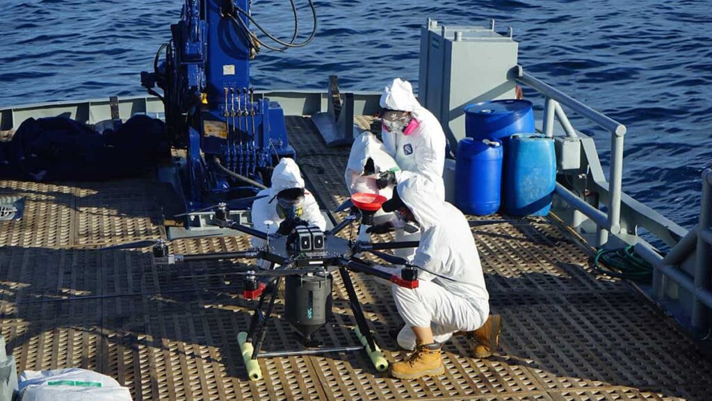
Island Conservation rat control drone in Galapagos

Island Conservation, an organization that focuses on removing invasive species, has announced that in conjunction with the Directorate of the Galápagos National Park (DPNG), it has used unmanned aerial vehicles (UAVs) to begin eradicating invasive rodents from North Seymour Island and the Mosquera Islet. These islands are important tourism and seabird nesting sites for species such as frigate birds and swallow-tailed gulls, which are the only nocturnal gull on the planet.

Monitoring activities in early 2018 determined that North Seymour was infested by black (Rattus rattus) and brown rats (Rattus norvegicus). DPNG immediately began managing the project’s development after declaring a state of emergency, which secured funds from the Fund for Sustainable Environmental Investments (FIAS). With the support of Island Conservation and New Zealand’s Environment and Conservation Technologies LTD., a pilot project was implemented using drones and hoppers with applicators designed in 3D printers. 52% coverage of North Seymour Island was possible using this equipment, making it the world’s first use of drones to remove invasive vertebrates.

Bell Laboratories produced 3,000 kilograms of rodenticide for the eradication. The bait’s formula was designed especially for projects within the Galápagos Archipelago due to their unique weather conditions.

The Guadalupe River (DPNG’s boat) was used as base camp for the project. Over 30 park rangers were equipped with masks, goggles, and protective clothing to manually disperse the bait on 48% of North Seymour’s 184 ha and the 5 ha of the Mosquera Islet, adjacent to the island.

Karl Campbell, Island Conservation South American Regional Director, highlighted that previously for this type of operations, it was necessary to use helicopters, specialized pilots, and bait spray buckets.

“The use of drones is more precise; it also increases feasibility, and reduces eradication costs of invasive rodents in small and midsize islands worldwide,” commented Campbell.

Prior to the application, tests and measurements were carried out to guarantee correct bait dispersion on the targeted area. Afterwards, park rangers proceeded with follow-up monitoring to verify the expected coverage in the established transects and bait consumption by the rodents.

Jorge Carrión, Director of Galápagos National Park, specified that a second application and monitoring will take place shortly to eliminate any remaining rodents.

Christian Sevilla, a park ranger, said that after the first phase of the project is complete, the ecological monitoring will continue for the next two years. This is the time needed to declare the island rodent-free and have evidence of the recovery of the ecosystem, monitoring the proliferation of cacti and other species.

Posted by Mike Ball Mike Ball is our resident technical editor here at Unmanned Systems Technology. Combining his passion for teaching, advanced engineering and all things unmanned, Mike keeps a watchful eye over everything related to the unmanned technical sector. With over 10 years’ experience in the unmanned field and a degree in engineering, Mike’s been heading up our technical team here for the last 8 years. Connect & Contact

Latest Articles

SightLine Software & Hardware Advancements for Enhanced ISR Applications

SightLine Applications LLC introduces the 3.9.2 update, enhancing the 4100 video processor and unveiling the ultra-compact 1710 processor for advanced ISR applications

Jul 16, 2025
Silicon Sensing’s MEMS Technology Enhances Vehicle Localization for Autonomous Driving

The University of Toronto investigated approaches to determining spatial awareness in autonomous vehicles, with Silicon Sensing's DMU41 IMU succeeding in cost-effectiveness, reliability and accuracy

Jul 16, 2025
CHC Navigation Launches AU20 MMS for Precision LiDAR Mapping of Infrastructure

CHC Navigation (CHCNAV) has unveiled the AU20 MMS, a vehicle-mounted mobile mapping system designed for accurate and efficient collection of 3D spatial data

Jul 16, 2025
ZIYAN to Highlight UAV Coordination & Unmanned Helicopter Solutions at IDEF 2025

ZIYAN Tech will unveil its latest combat UAV technologies at IDEF 2025, highlighting advanced swarm coordination, ISR systems, and unmanned helicopter capabilities

Jul 16, 2025
Boosting First Responder Drones with Advanced BVLOS Technology

DroneSense and MatrixSpace partner to enhance BVLOS capabilities, accelerating the safe, scalable use of drones in public safety and Drone as First Responder missions

Jul 16, 2025
TEKEVER Advancing Defense & Civil Security Drones with Cahors Centre of Excellence

Tekever will establish a new dual-use Centre of Excellence in Cahors, France to develop, test, integrate and industrialize autonomous defense and security technologies

Jul 16, 2025

Featured Content

SBG Systems Evaluates INS Performance in GNSS-Denied Marine Applications

SBG Systems evaluates the performance of its INS solutions in GNSS-denied marine environments, comparing system accuracy with and without DVL and warm-up support

Jul 14, 2025
USAF Uses Inertial Labs Drone Lidar for Tree Obstruction Survey

The US Air Force successfully used Inertial Labs drone Lidar and cloud software to quickly map tree obstructions at Joint Base Lewis-McChord (JBLM), improving airfield safety

Jul 11, 2025
New UAV to Combine Solar Hydrogen & Battery Power for Extended Flight

XSun and H3 Dynamics are developing the first UAV powered by solar, hydrogen, and batteries, aiming to deliver zero-emission, long-endurance unmanned flight

Jul 07, 2025
Advancing Unmanned Systems Through Strategic Collaboration UST works with major OEMs to foster collaboration and increase engagement with SMEs, to accelerate innovation and drive unmanned systems capabilities forward.