New Commercial Quadcopter UAV Features 40-Minute Flight Time

By Mike Ball / 30 Apr 2018

Quadcopter Drones

Discover cutting-edge solutions from 22 leading global suppliers
SUPPLIER SPOTLIGHT
Follow UST

AEE Aviation Technology Mach 4 drone

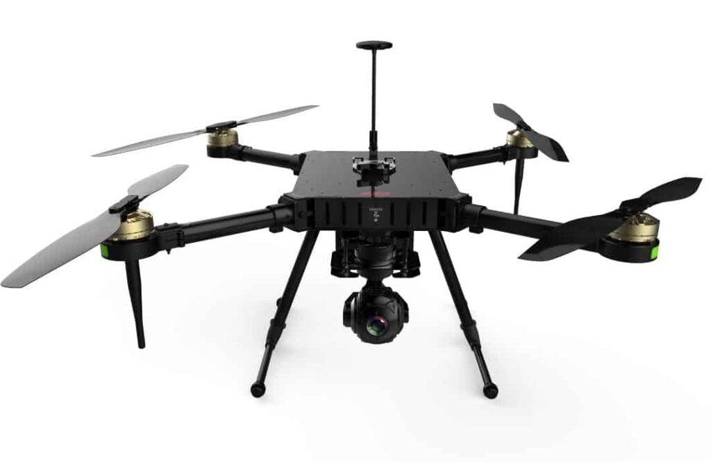
AEE Aviation Technology has announced the introduction of the Mach 4, a multiple-payload capable commercial UAV (unmanned aerial vehicle) designed for professionals in fields such as law enforcement, search & rescue, inspection and surveying. AEE will be exhibiting Mach 4 at the AUVSI Xponential conference in Denver.

Measuring a little over two-feet in length, the AEE’s Mach 4 is capable of traveling at a cruising speed of close to 30 miles per hour with a range of almost two miles and flight times up to 40 minutes in length. Its Y-12 ground station hand controller is equipped with 1.4 gigahertz for flight control, offering a steady and sure control experience. The drone package comes with an aluminum siding carrying case that includes a professional charger and battery pack along with three antennas which are attached to the ground station, which supports a 5.8GHz video transmission and a 1.4 GHz digital radio system. Equipped with an YT35, standard 4K camera with a 1 / 2.3-megapixel sensor, the Mach 4 is designed to deliver crisp, clear images. The Mach 4 will also have available 10:1 zoom camera payload as well as an advanced optical thermal payload for search & rescue along with inspection missions.

“We are pleased to offer to the Mach 4 to our commercial customers around the world because we expect the Mach 4 to raise the bar and redefine value in the commercial UAV industry,” said AEE founder and CEO Andy Zheng. “One key advantage, for example, of the Mach 4 is its long flight time and we also believe its ground station controller is in a class by itself for similar products at this price point.”

Posted by Mike Ball Mike Ball is our resident technical editor here at Unmanned Systems Technology. Combining his passion for teaching, advanced engineering and all things unmanned, Mike keeps a watchful eye over everything related to the unmanned technical sector. With over 10 years’ experience in the unmanned field and a degree in engineering, Mike’s been heading up our technical team here for the last 8 years. Connect & Contact

Latest Articles

Who to see at Xponential 2025

UnmannedSystemsTechnology.com are thrilled to be working with so many companies attending AUVSI's Xponential this year...

May 12, 2025
GuideNav: Top MEMS IMUs for UAV Flight Control

GuideNav examines MEMS IMU selection for UAV control, comparing accuracy bands and performance levels across consumer, industrial, and military-grade applications

May 12, 2025
Aurora Flight Sciences Advances sUAS Range with New Upgrades

Aurora Flight Sciences has enhanced its SKIRON-X sUAS range to improve flight performance and simplify operation

May 12, 2025
ATL Fuel Bladders for Unmanned Systems to Feature at XPO25

Aero Tec Laboratories (ATL) will present its latest fuel bladder technologies for unmanned systems at XPONENTIAL 2025, highlighting solutions for air, land, and sea

May 12, 2025
uAvionix Unveils Wearable ADS-B Receiver for UAS Operations

uAvionix announces skyAlert, a rugged, wearable ADS-B receiver purpose-built for professional UAS pilots and their visual observers

May 12, 2025
ParaZero Secures European Order for Drone Parachute Safety System

ParaZero receives a significant European order for its SafeAir™ M4 system, highlighting rising demand for advanced drone safety solutions in high-regulation markets

May 12, 2025

Featured Content

New Tactical Grade IMU from Inertial Labs for UAVs & Guided Munitions

Inertial Labs has launched the IMU-H100, a compact, tactical-grade MEMS IMU designed to enhance precision navigation for UAVs and guided systems

May 08, 2025
Geolocation in GPS-Denied Environments Successfully Demonstrated

Trillium Engineering's GD-Loc, integrated with the HD55-MV gimbal on a Group 2 UAS, has successfully demonstrated sustained Category 1 geolocation accuracy within six meters, highlighting its critical advantage for precise ISR missions in GPS-denied environments

May 06, 2025
Spexi + LayerDrone: A New Era of Aerial Intelligence

Imagine a real-time, crowd-sourced map of Earth. Spexi, powered by LayerDrone, pays drone pilots to capture ultra-detailed imagery, offering organizations data that’s faster, cheaper, and more precise than traditional methods

Apr 29, 2025
Advancing Unmanned Systems Through Strategic Collaboration UST works with major OEMs to foster collaboration and increase engagement with SMEs, to accelerate innovation and drive unmanned systems capabilities forward.