Sentera Agricultural Drone Captures RGB, Thermal and NVDI Data

By Mike Ball / 20 Sep 2017

Smart Sourcing for Unmanned Systems

Discover cutting-edge solutions from leading global suppliers
SUPPLIER SPOTLIGHT
Follow UST

Sentera Omni drone

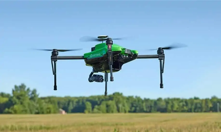
Sentera has announced the new capability of its Omni quadcopter drone to capture three distinct crop health data measurements in a single flight: thermal, normalized difference vegetation index (NDVI), and high-resolution RGB. Pairing a DJI XT Thermal sensor with Omni’s standard Double 4K offers agronomists, crop consultants, advisors, and producers a precise agriculture data capture tool that offers multi-dimensional insights.

“We are excited to respond to our customers’ unique application needs and extend the Omni Ag system’s already robust payload capabilities to include thermal imaging,” commented Kris Poulson, vice president of agriculture for Sentera. “The ability to access three precise layers of data in one flight helps create an even greater scouting experience. The added ability to capture thermal data allows professionals to further evaluate plant health and practices as reflected through plant and soil temperatures.”

While no sensor can diagnose specific diseases in plants, the Sentera Omni drone with thermal, NDVI, and RGB data-capture capability gives ag professionals a head start detecting and diagnosing issues earlier and more efficiently.

Poulson explained: “The ability to quickly and accurately pinpoint plants that appear to be sick is critical. With this knowledge, users can quickly ground-truth the area and take the appropriate action before a problem potentially gets worse.”

Thermal technology is also ideal for irrigated crops. A thermal measurement can quickly show where areas within a field are under or over-irrigated, or where equipment is malfunctioning.

Thermal sensors are also useful when locating or confirming installation of subsurface drainage. “Historically, the most common way to detect preinstalled drain tile was to probe and dig, which was extremely inefficient and time-consuming. Now, through thermal technology, users can identify cooler areas of a field which would be an indication of the presence of drain tile. Users then can focus their efforts on that area,” says Poulson.

The Sentera Omni Ag drone with DJI XT Thermal Sensor is also compatible with Sentera’s other Double 4K sensor variants, including the multispectral Double 4K sensor.

Posted by Mike Ball Mike Ball is our resident technical editor here at Unmanned Systems Technology. Combining his passion for teaching, advanced engineering and all things unmanned, Mike keeps a watchful eye over everything related to the unmanned technical sector. With over 10 years’ experience in the unmanned field and a degree in engineering, Mike’s been heading up our technical team here for the last 8 years. Connect & Contact

Latest Articles

Elistair’s Tethered Drone System Integrated into Autonomous Port Security Project

Elistair's tethered drone system will provide continuous surveillance of ports from an autonomous vessel as part of the European SMAUG project

Jun 12, 2025
MEMS DC Accelerometers from SDI Deliver Superior Performance for Unmanned Systems

SDI's MEMS DC accelerometers offer a robust solution for unmanned aerial, ground, and underwater vehicles, providing precise static and dynamic motion sensing, crucial for autonomous navigation, attitude feedback, and structural monitoring

Jun 12, 2025
AWI Completes First Under-Ice Dive in the Arctic with an ecoSUB AUV

The Alfred Wegener Institute (AWI) has completed the first under-ice deployment of ecoSUB's smallest autonomous underwater vehicle (AUV) the ecoSUB-µ5 during a mission in Arctic conditions

Jun 12, 2025
SatLab Geosolutions Introduces HydroBoat 1200MB Integrated USV Survey Solution

SatLab Geosolutions’ new HydroBoat 1200MB combines USV technology and the HydroBeam M2 sonar for real-time 3D surveys, offering fast deployment, high efficiency, and reduced operational costs

Jun 12, 2025
Trillium Unveils Lightweight Imaging System for Medium & Long-Range Reconnaissance

Trillium Engineering introduces the HD45-LV-R, a lightweight, high-performance imaging system designed to enhance LRR and MRR reconnaissance missions for modern defense platforms

Jun 12, 2025
How to Select the Right IMU for UAV Applications

GuideNav outlines the critical considerations for selecting an IMU that matches your UAV’s performance, durability, size, and mission requirements

Jun 12, 2025

Featured Content

Calian GNSS Unveils New Anti-Jamming CRPA with XF+ Filtering

Calian GNSS has introduced the CR8894SXF+, a compact CRPA antenna with in-band null forming and XF+ filtering for resilient GNSS performance in interference-prone environments

Jun 06, 2025
Honeywell Introduces HG3900 Tactical-Grade IMU with Enhanced Sensor Accuracy

Honeywell has introduced the HG3900 IMU, a MEMS-based device with tactical-grade accuracy, offering significant SWaP advantages for precision navigation systems

Jun 05, 2025
TEKEVER Invests £400 Million to Advance UK Defense & Drive AI Innovation

TEKEVER is investing £400 million in UK defense innovation, creating 1,000+ jobs and advancing AI, autonomy, and electronic warfare through its five-year OVERMATCH program

May 29, 2025
Advancing Unmanned Systems Through Strategic Collaboration UST works with major OEMs to foster collaboration and increase engagement with SMEs, to accelerate innovation and drive unmanned systems capabilities forward.