NOAA Uses UAVs to Track and Model Hurricane Maria

By Mike Ball / 28 Sep 2017

Smart Sourcing for Unmanned Systems

Discover cutting-edge solutions from leading global suppliers
SUPPLIER SPOTLIGHT
Follow UST

Raytheon Coyote UAS

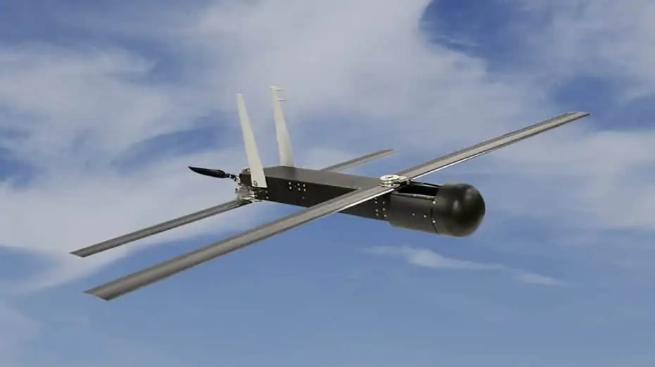
Raytheon has announced that the National Oceanic and Atmospheric Administration (NOAA) has used six of the company’s Coyote unmanned aerial vehicles (UAVs) to track and model Hurricane Maria. Launched from a NOAA WP-3D Orion hurricane hunter aircraft, the Coyotes flew directly into the storm, giving researchers an unprecedented view of Maria from a safe distance.

Developed for the military, Coyote is a small, expendable UAV that can be air- or ground-launched into environments too dangerous for manned aircraft. The system can fly for more than an hour and up to 50 miles from its host aircraft.

“Raytheon technology is enabling hurricane hunters to understand storm behavior in new and better ways,” said Dr. Thomas Bussing, Raytheon vice president of Advanced Missile Systems. “Our expendable Coyote UAVs are delivering vital information about these potentially deadly storms—and that can help save lives.”

Navigating Maria’s winds of greater than 100 miles per hour, the Coyotes gathered and transmitted storm information directly to the National Hurricane Center. NOAA scientists are evaluating the data to better understand Hurricane Maria and other storms like it.

“NOAA is investing in these unmanned aircraft and other technologies to increase weather observations designed to improve the accuracy of our hurricane forecasts,” said Dr. Joe Cione, NOAA hurricane researcher and chief scientist for the Coyote program. “The Coyotes collected critical, continuous observations in the lower part of the hurricane, an area impossible to reach with manned aircraft.”

Researchers can also fly Coyotes throughout the storms, revisiting key locations inside hurricanes to obtain the most robust data possible.

The Coyote system is one of Raytheon’s family of high-tech weather forecasting technology, including the Visible Infrared Imaging Radiometer Suite instrument aboard NOAA’s Suomi NPP spacecraft, the common ground system for the Joint Polar Satellite System, and the Advanced Weather Interactive Processing System, a powerful forecast toolkit that helps meteorologists make sense of the massive amounts of weather data that modern sensors collect.

Posted by Mike Ball Mike Ball is our resident technical editor here at Unmanned Systems Technology. Combining his passion for teaching, advanced engineering and all things unmanned, Mike keeps a watchful eye over everything related to the unmanned technical sector. With over 10 years’ experience in the unmanned field and a degree in engineering, Mike’s been heading up our technical team here for the last 8 years. Connect & Contact

Latest Articles

Klein Marine Systems Integrates Exail Navigation Solution into Side Scan Sonar

Klein Marine Systems has integrated Exail’s advanced AHRS into its 5900 sonar, enhancing accuracy, stability, and efficiency for demanding underwater mapping missions

Apr 24, 2025
Expanding Modular Maritime Autonomy with TSUNAMI USV Line

Textron Systems is expanding its USV capabilities with the TSUNAMI™ family, a series of modular, scalable platforms designed to meet the demands of autonomous maritime operations

Apr 24, 2025
Strategic Value of Protective Coatings in Electronic System Reliability

HZO highlights the role of protective coatings like Parylene in delivering long-term operational value for sensitive electronic components across a wide range of industries

Apr 24, 2025
Inspired Flight CEO Discusses Leadership, Innovation & the Future of Drone Technology

Inspired Flight Technologies CEO, Rick Stollmeyer, discusses advancing drone technology, highlighting innovation, leadership, and the mission of reshoring critical manufacturing to America

Apr 24, 2025
Vision-Based Traffic Detection Enhances BVLOS Safety for Xer X8 Hybrid UAV

Xer Technologies teams up with Daedalean to enhance BVLOS drone safety, integrating vision-based traffic avoidance into the robust, hybrid-electric Xer X8 multirotor drone

Apr 24, 2025
Sierra-Olympia Launches Long-Wave Infrared OGI Camera for Continuous Gas Monitoring

Sierra-Olympia Technologies unveils the Viento LWIR OGI, a cost-effective infrared camera designed for continuous, reliable gas leak detection in industrial environments

Apr 24, 2025

Featured Content

Apollo & Moonrock Launch $122.5m Drone, eVTOL Insurance Facility

Apollo and Moonrock take the lead on new $122.5m drone, eVTOL and aviation innovation insurance facility

Apr 22, 2025
ParaZero Unveils Advanced Parachute Recovery System

ParaZero launches the SafeAir M4, an advanced parachute recovery system designed for the DJI Matrice 4, enhancing drone safety, compliance, and mission readiness

Apr 17, 2025
Compact High Resolution MWIR Zoom Lens Released for UAV & ISR Platforms

MKS Instruments introduces the Ophir SupIR 10-135mm f/1.8 zoom lens, engineered for compact MWIR systems demanding long-range detection and high-resolution thermal imaging

Apr 17, 2025
Advancing Unmanned Systems Through Strategic Collaboration UST works with major OEMs to foster collaboration and increase engagement with SMEs, to accelerate innovation and drive unmanned systems capabilities forward.