Verizon Conducts Flight Tests of New Drone-Based 4G LTE Service

By Mike Ball / 17 Apr 2017

Smart Sourcing for Unmanned Systems

Discover cutting-edge solutions from leading global suppliers
SUPPLIER SPOTLIGHT
Follow UST

Verizon 4G LTE drone test

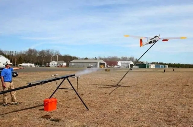
Verizon has announced that it has conducted the latest engineering flight tests to determine how large an area of wireless coverage can be created aerially using a “flying cell site” aboard a long endurance drone piloted by American Aerospace Technologies, Inc. (AATI).

This latest technical test of Airborne LTE took place at Woodbine Municipal Airport in Woodbine, New Jersey and was designed to simulate an environment in which commercial power is knocked out indefinitely after a severe weather event or other disaster that interrupts traditional communications services.

The test was conducted under a Certificate of Waiver or Authorization (COA) issued by the FAA to Cape May County in preparation for a major emergency preparedness exercise involving county, state and federal emergency responders.

“This new test builds upon our leadership in conducting the first successful demonstration in the U.S. for providing aerial coverage from a long-endurance medium altitude aircraft with AATI in Cape May last October,” said Christopher Desmond, Verizon Network.

The RS-20 unmanned aircraft system (UAS) used for the test has a 17-foot wing span.

David Yoel, AATI CEO, said the goal of the flight test was to simulate an environment in which a disaster such as a hurricane or flood had destroyed an area’s cell network while demonstrating the drone’s ability to provide first responders with communications to improve their safety and effectiveness.

Yoel said the COA covers 800 square miles of airspace up to 7,000 feet. He added that the county’s public safety mission extends beyond its borders and that the COA could be adjusted for natural disasters and other emergency situations.

Marty Pagliughi, Cape May County Office of Emergency Management coordinator, noted that the two biggest uses for UAS for emergency management would be communications and damage assessment.

“They can provide live situation reports, live stream situation reports and damage assessments, and show access points for emergency service vehicles,” he said.

Posted by Mike Ball Mike Ball is our resident technical editor here at Unmanned Systems Technology. Combining his passion for teaching, advanced engineering and all things unmanned, Mike keeps a watchful eye over everything related to the unmanned technical sector. With over 10 years’ experience in the unmanned field and a degree in engineering, Mike’s been heading up our technical team here for the last 8 years. Connect & Contact

Latest Articles

Most Read Articles on UST This Week

Here’s our round-up of the five most read articles on UnmannedSystemsTechnology.com this week

Feb 14, 2025
FlyingBasket to Discuss Drone Industry Challenges at XPO Europe

FlyingBasket CTO Matthias Moroder will join a panel at Xponential Europe to discuss the regulatory and market challenges hindering drone industry growth, and the importance of collaboration for wider adoption

Feb 14, 2025
Advanced EFI Engines for Commercial & Industrial Drones

INF Inject's 2- and 4-stroke EFI engines can be provided with a range of options such as alternators, starter-alternators and generators

Feb 14, 2025
SDO 50 UAV Completes Long-Distance BVLOS Pipeline Inspection

SwissDrones’ SDO 50 UAV has successfully carried out a 550-kilometer BVLOS pipeline inspection in Queensland, providing precise, actionable data while maintaining high safety standards

Feb 14, 2025
Enhancing Unmanned System Reliability with SCS Silicone Conformal Coatings

Specialty Coating Systems (SCS) provides advanced conformal coating solutions to protect unmanned systems’ electronics from extreme conditions, ensuring durability, reliability, and compliance with evolving industry standards

Feb 14, 2025
Explore Geospatial Tools with Blue Marble at XPONENTIAL Europe

Blue Marble Geographics will showcase advanced geospatial software at XPONENTIAL Europe 2025, featuring live demos of the Global Mapper Suite and advanced geospatial tools

Feb 14, 2025

Featured Content

Military Vehicles to Feature Small Tethered UAS from Elistair

Elistair has secured a €3 million contract to equip military vehicles with tethered UAS, enhancing real-time intelligence and operational awareness

Feb 13, 2025
Ellipse Series Enhanced with Latest Firmware Upgrade

The new firmware update from SBG Systems integrates the latest World Magnetic Model (WMM) to improve navigation precision, even for first-generation Ellipse sensors

Feb 11, 2025
Advanced FOG-Based Inertial Sensing Solutions for Drones & Robotics

Aegiverse's products feature a multi-layered architecture that combines multiple elements into a compact module, providing significant, size, weight and cost reductions

Feb 06, 2025