Pix4D and Parrot Drones Create 3D Multispectral Images of National Park

By Mike Ball / 07 Dec 2016

Smart Sourcing for Unmanned Systems

Discover cutting-edge solutions from leading global suppliers
SUPPLIER SPOTLIGHT
Follow UST

Multispectral 3D image of National Park

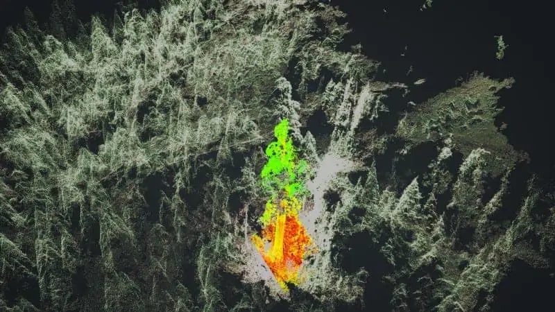
Pix4D has announced that, as part of a joint project with Parrot, it has used drones and multispectral technology to create a 3D NDVI point cloud of Whitaker’s Forest in Kings Canyon National Park, giving researchers access to information previously hidden. Large air purifiers such as the giant sequoia trees in the Californian national park are key for the environment, and studied to measure how much CO2 they capture.

Multispectral images capture what human eyes cannot: information from spectral bands beyond our sight range. While mapping and modeling from images is increasingly commonplace, multispectral imagery has been limited to 2D map creation. This is a tremendous limitation for all those using multispectral imagery, as without 3D, critical pieces of information may be missing. Recognizing this, Pix4D developed a methodology to leverage multispectral images for 3D point cloud generation.

These special 3D point clouds are produced by merging radiometric information acquired from different spectral bands into a single 3D point cloud geometry. After doing radiometric corrections to obtain reflectance, the observations of a particular point in each band are weighted separately, taking visibility constraints into account to avoid obstructed points, and obtaining a representative reflectance value for that band. As a result, each point in the point cloud contains accurate reflectance values for each observed band. Then the reflectance values are combined according to the Vegetation Index formula that needs to be applied.

Vegetation is not only analyzable from the top-down, but also in 3D, allowing foresters, agronomists and a wide range of other environmental workers to recognize problems in the whole structure of the plant. For example, forest conservation organizations can document the trees with both geometric and radiometric information much faster, rather than spending days to survey and CAD-draw individual trees.

The end result is a 3D NDVI point cloud, where plants can be observed and scouted in their entirety, adding a new dimension to an industry previously constrained to information from plant canopies.

Watch the video below for more information:

Posted by Mike Ball Mike Ball is our resident technical editor here at Unmanned Systems Technology. Combining his passion for teaching, advanced engineering and all things unmanned, Mike keeps a watchful eye over everything related to the unmanned technical sector. With over 10 years’ experience in the unmanned field and a degree in engineering, Mike’s been heading up our technical team here for the last 8 years. Connect & Contact

Latest Articles

Contract Electronics Manufacturing Services for Unmanned Systems & Robotics

Offshore Electronics' comprehensive and cost-effective CEM services allow OEMs to meet their outsourcing needs and achieve faster times to market

Mar 18, 2025
How IONA Reaches the Last Mile Through Smart Product Development

In this webinar, learn from Drone Industry Insights about scaling production and supply chain challenges, strategies from Arena by PTC to optimize product development, and how IONA Drones are advancing last-mile delivery

Mar 18, 2025
Establishing a Cost-Effective RTK Base Station for DJI Drones

ArduSimple's latest guide details the step-by-step process for establishing a cost-effective RTK system that delivers real-time GNSS corrections without internet access

Mar 18, 2025
Brazil Funds Portable Ground Control System for High-Capacity Drones

Brazil's FINEP has awarded Moya Aero a grant to develop an AI-powered, portable ground control system for high-capacity drones, enhancing cargo transport efficiency and sustainability

Mar 18, 2025
Testing Complete for Micrometeorology & Fire Response Drones

NASA's Alta X quadcopter has completed testing in Montana for applications in micrometeorology using two sensors, a radiosonde and a LI-COR LI-560 Trisonica anemometer

Mar 18, 2025
DTC’s New Solution Delivers High-Quality Video Streaming in Challenging Environments

DTC introduces Vidar, an advanced video compression solution designed for real-time, high-quality streaming in challenging environments, ideal for mission-critical applications like defense and security

Mar 18, 2025

Featured Content

How IONA Reaches the Last Mile Through Smart Product Development

In this webinar, learn from Drone Industry Insights about scaling production and supply chain challenges, strategies from Arena by PTC to optimize product development, and how IONA Drones are advancing last-mile delivery

Mar 18, 2025
Nokia Talks to UST about 4G/5G Connected Drone-in-a-Box Advancements

How Nokia is revolutionizing drone connectivity with 4G and 5G, and advancing autonomous operations with the cutting-edge drone-in-a-box solution; Nokia Drone Networks

Mar 16, 2025
Ascent AeroSystems Launches AI-Enabled Sub-250g Coaxial Nano UAV

Ascent AeroSystems has unveiled HELIUS, a sub-250g AI-enabled UAV designed for law enforcement, emergency response, and industrial use, offering a compact, NDAA-compliant alternative to existing systems

Mar 13, 2025
Advancing Unmanned Systems Through Strategic Collaboration UST works with major OEMs to foster collaboration and increase engagement with SMEs, to accelerate innovation and drive unmanned systems capabilities forward.