NATS and Altitude Angel Release New App for UK Drone Pilots

By Mike Ball / 06 Dec 2016

Smart Sourcing for Unmanned Systems

Discover cutting-edge solutions from leading global suppliers
SUPPLIER SPOTLIGHT
Follow UST

Drone Assist app

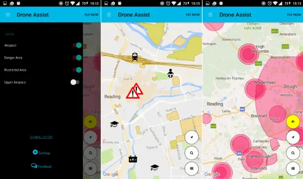
NATS and cloud technology developer Altitude Angel have announced that they have developed an app in response to the significant increase in reports of near misses between drones and commercial aircraft in the UK. Such incidents cause disruption to air traffic and risk a major incident.

Drone Assist is available for free on Android and iOS and presents drone pilots with an interactive map of areas of airspace used by commercial air traffic. Drone operators planning to fly near these areas – usually around airports and airfields – should ideally avoid them or exercise great caution. It will also contain a ‘Fly Now’ feature that will share the user’s drone flight location with other app users, and the wider drone community, helping to reduce the risk of a drone related incident in the UK’s airspace.

The app also includes the location of ground based hazards that might pose a safety or privacy risk, such as power lines, schools or sports venues.

Phil Binks, NATS drone lead, said: “With the number of drone incidents on the rise, it’s clear that many people are unaware of the rules as set by the Civil Aviation Authority or their legal obligations as pilots. Drone Assist is designed to help everyone abide by the rules, identify areas of controlled and restricted airspace, therefore helping them to enjoy flying whilst ensuring their safety and the safety of other airspace users.”

“We’re delighted to have partnered with Altitude Angel to develop a tool that we hope will help improve drone safety in the UK and lead the way in international best practise.”

Richard Parker, founder and CEO of Altitude Angel, commented: “We are delighted to be working with NATS, and are proud that the UK is taking a global lead in addressing this issue as we work to keep our skies safe for all aerial citizens. Partnerships like this are an essential first-step to bringing together drone pilots and other stakeholders, all working towards greater airspace safety, and laying the foundation for a future where drones and manned aircraft can coexist without incident.”

In a recent study by the CAA, 40% of drone owners were aware of the CAA’s Dronecode, but few could recall specific rules when asked. Tools like Drone Assist are designed to help, as is the new website launched by NATS and the CAA called dronesafe.uk. The site, which is easily accessible directly within the app, provides further information on the rules around drone flying in the UK, including the CAAs Drone Code and information on CAA-approved training courses.

Posted by Mike Ball Mike Ball is our resident technical editor here at Unmanned Systems Technology. Combining his passion for teaching, advanced engineering and all things unmanned, Mike keeps a watchful eye over everything related to the unmanned technical sector. With over 10 years’ experience in the unmanned field and a degree in engineering, Mike’s been heading up our technical team here for the last 8 years. Connect & Contact

Latest Articles

High-Energy Density Batteries for Drones & Robotic Vehicles

The SCIO Brick® platform offers industry-leading energy density in a compact and lightweight footprint, and can be scaled to meet high-voltage requirements

Jul 12, 2025
Most Read Articles on UST This Week

Here’s our round-up of the five most read articles on UnmannedSystemsTechnology.com this week

Jul 11, 2025
Vertiq Speed Firmware v0.1.1 Now Available with Bug Fixes

Vertiq has released firmware v0.1.1 to correct a parameter bug affecting telemetry and 3D mode settings on select G1 and G2 modules

Jul 11, 2025
The Role of ROVs in Unmanned Marine Operations

Oceanbotics has answered the most common questions about ROVs, covering how they work, where they're used, and key capabilities

Jul 11, 2025
LiveU File Transfer Speeds Up Drone Data Delivery for Critical Missions

LiveU’s File Transfer enables rapid transmission of large drone data files, reducing delays and supporting faster decision-making in public safety and infrastructure operations.

Jul 11, 2025
Exploring Differences Between M9PLUS & M9 GNSS Antennas

Discover the key upgrades in Maxtena’s new M9PLUS GNSS antenna, including improved performance, signal purity, and multipath mitigation over the original M9

Jul 11, 2025

Featured Content

USAF Uses Inertial Labs Drone Lidar for Tree Obstruction Survey

The US Air Force successfully used Inertial Labs drone Lidar and cloud software to quickly map tree obstructions at Joint Base Lewis-McChord (JBLM), improving airfield safety

Jul 11, 2025
New UAV to Combine Solar Hydrogen & Battery Power for Extended Flight

XSun and H3 Dynamics are developing the first UAV powered by solar, hydrogen, and batteries, aiming to deliver zero-emission, long-endurance unmanned flight

Jul 07, 2025
Enhancing Mangrove Restoration Through 3D Printed Drone Design

Explore how Inverto Earth, in collaboration with HP Additive, is using sustainable 3D printing and drone technology to drive large-scale mangrove restoration and protect vulnerable coastal ecosystems

Jul 03, 2025
Advancing Unmanned Systems Through Strategic Collaboration UST works with major OEMs to foster collaboration and increase engagement with SMEs, to accelerate innovation and drive unmanned systems capabilities forward.