Airbus Demonstrates Aircraft Inspection by UAV

By Mike Ball / 14 Jul 2016

Smart Sourcing for Unmanned Systems

Discover cutting-edge solutions from leading global suppliers
SUPPLIER SPOTLIGHT
Follow UST

Airbus Drone Inspection

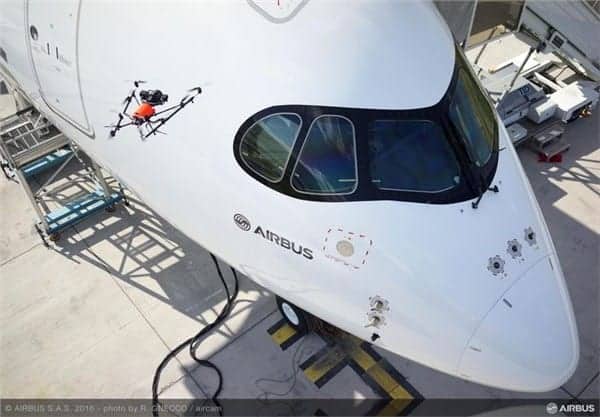
Airbus has demonstrated aircraft visual inspection using a drone at the Farnborough Airshow.

The Unmanned Aerial Vehicle (UAV), equipped with a high definition camera, performed visual inspection for the upper part of the aircraft. It was flown using an automatic flight control system supervised by a human pilot. The drone followed a predetermined flight path and took a series of pictures automatically. All these images, especially those showing any potential non-quality such as scratches, dents and painting defects, are compiled in a 3D digital model, recorded in a database and then analysed. This data helps improve traceability, prevention and reduction of damage.

The benefits of this innovative tool and process are significant. Aircraft downtime for inspection is reduced. Data acquisition by drone only takes 10 to 15 minutes, instead of 2 hours using conventional methods.

“The use of this new technology offers better working conditions including improving the safety and comfort for the quality inspectors,” says Nathalie Ducombeau, Airbus head of quality.

Operators no longer need to go up on a telescopic handler to perform the visual inspection, sometimes in poor weather conditions. In addition, picture analysis can be done anytime afterwards and in an office.

A full-scale industrial test is being conducted on A330 aircraft. Airbus is working on implementation on other programmes.

Posted by Mike Ball Mike Ball is our resident technical editor here at Unmanned Systems Technology. Combining his passion for teaching, advanced engineering and all things unmanned, Mike keeps a watchful eye over everything related to the unmanned technical sector. With over 10 years’ experience in the unmanned field and a degree in engineering, Mike’s been heading up our technical team here for the last 8 years. Connect & Contact

Latest Articles

UK MOD Validates PDW C100 for Aerial Target Designation

Performance Drone Works (PDW) demonstrated the capabilities of its C100 quadcopter for the UK MOD, successfully designating targets with precision and completing extended-range missions during a live-fire event in Texas

Jul 09, 2025
SatLab Showcases Geospatial Technologies at CSPI-EXPO 2025

SatLab attended CSPI-EXPO 2025 in Chiba, Japan from 18-21 June, showcasing its latest innovations across the full spectrum of geospatial solutions

Jul 09, 2025
DeltaQuad Collaboration to Boost VTOL Surveillance Drone Production

DeltaQuad has partnered with VDL Groep to expand production of its Evo surveillance drone, enhancing manufacturing capabilities to meet rising defence sector demand

Jul 09, 2025
FarSounder Argos Powers Autonomous Navigation on Unmanned Surface Vessel

FarSounder’s Argos sonar technology has been integrated into DARPA’s NOMARS vessel, advancing autonomous navigation and situational awareness in unmanned maritime operations

Jul 09, 2025
Impact of Jamming & Spoofing on GNSS Positioning

Tersus GNSS explains how jamming and spoofing interfere with GNSS signals, outlines their distinct impacts, and presents technical strategies for detection and mitigation

Jul 09, 2025
ESA Feasibility Study to Advance Autonomous Drone Landing Without GPS

Agilica completes an ESA-backed study advancing precision drone landing tech that works without GPS, targeting urban, maritime, and complex autonomous UAV operations

Jul 09, 2025

Featured Content

New UAV to Combine Solar Hydrogen & Battery Power for Extended Flight

XSun and H3 Dynamics are developing the first UAV powered by solar, hydrogen, and batteries, aiming to deliver zero-emission, long-endurance unmanned flight

Jul 07, 2025
Enhancing Mangrove Restoration Through 3D Printed Drone Design

Explore how Inverto Earth, in collaboration with HP Additive, is using sustainable 3D printing and drone technology to drive large-scale mangrove restoration and protect vulnerable coastal ecosystems

Jul 03, 2025
Partnership Combines Drone Swarms & Situational Awareness to Boost Wildfire Response

Kongsberg Geospatial and FireSwarm Solutions have partnered to integrate autonomous drone swarms with real-time situational awareness for faster, smarter wildfire response

Jun 30, 2025
Advancing Unmanned Systems Through Strategic Collaboration UST works with major OEMs to foster collaboration and increase engagement with SMEs, to accelerate innovation and drive unmanned systems capabilities forward.