Woolpert Collects Imagery via Drone for Rural Roads Project

By Mike Ball / 25 Mar 2016

Smart Sourcing for Unmanned Systems

Discover cutting-edge solutions from leading global suppliers
SUPPLIER SPOTLIGHT
Follow UST

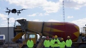
Woolpert UASWoolpert, an engineering and geospatial services firm, has announced that it has been hired by Michigan Tech Research Institute (MTRI) to collect imagery via unmanned aerial system (UAS) of haul roads throughout the Midwest.

This project, “Characterization of Unpaved Road Conditions Through the Use of Remote Sensing,” is sponsored by the U.S. Department of Transportation (USDOT), Office of the Assistant Secretary for Research and Technology (OST-R).

The data collected will help test a set of algorithms developed by MTRI, a branch of Michigan Technological University located in central Michigan.

“The contract is to help commercialize computerized analysis and assessment of unpaved roads,” said Aaron Lawrence, Woolpert GIS expert and UAS technology developer. “Michigan Tech has some algorithms to detect potholes, rutting, damage, etc., through high-resolution imagery and 3D point clouds, which would be used to assess and address unstable roads.”

The UAS is intended to provide a fast, safe and cost-effective collection to better understand where road material is lost and what damage there is to these roads.

“If I’ve got a 25-ton truck on a dirt road, and the road bank is unstable, that would be a safety hazard,” Lawrence said. “The key is identifying these issues before something bad happens.”

Woolpert has been employing UAS for multiple industries that require efficient, remote and highly accurate imagery collections.

In addition to roads projects, the national architecture, engineering and geospatial firm is tasking UAS for oil and gas surveying, site design and civil engineering.

“UAS is ideally suited to smaller, rural sites,” Lawrence said. “It’s safer and it’s more cost-effective than flying individual manned aircraft missions, and in many cases we can turn around the imagery in 24 hours or less.”

Lawrence added that gathering imagery and generating 3D models of construction sites and the unpaved roads that provide access to them helps companies monitor construction, inventory material or simulate runoff scenarios to ensure designated retention ponds are collecting material as designed, instead of the surrounding rivers and streams.

“Post-construction UAS imagery can be very useful because it captures significant change to the area after companies clear and level land, install equipment or build haul roads,” Lawrence said.

Posted by Mike Ball Mike Ball is our resident technical editor here at Unmanned Systems Technology. Combining his passion for teaching, advanced engineering and all things unmanned, Mike keeps a watchful eye over everything related to the unmanned technical sector. With over 10 years’ experience in the unmanned field and a degree in engineering, Mike’s been heading up our technical team here for the last 8 years. Connect & Contact

Latest Articles

Elistair’s Tethered Drone System Integrated into Autonomous Port Security Project

Elistair's tethered drone system will provide continuous surveillance of ports from an autonomous vessel as part of the European SMAUG project

Jun 12, 2025
MEMS DC Accelerometers from SDI Deliver Superior Performance for Unmanned Systems

SDI's MEMS DC accelerometers offer a robust solution for unmanned aerial, ground, and underwater vehicles, providing precise static and dynamic motion sensing, crucial for autonomous navigation, attitude feedback, and structural monitoring

Jun 12, 2025
AWI Completes First Under-Ice Dive in the Arctic with an ecoSUB AUV

The Alfred Wegener Institute (AWI) has completed the first under-ice deployment of ecoSUB's smallest autonomous underwater vehicle (AUV) the ecoSUB-µ5 during a mission in Arctic conditions

Jun 12, 2025
SatLab Geosolutions Introduces HydroBoat 1200MB Integrated USV Survey Solution

SatLab Geosolutions’ new HydroBoat 1200MB combines USV technology and the HydroBeam M2 sonar for real-time 3D surveys, offering fast deployment, high efficiency, and reduced operational costs

Jun 12, 2025
Trillium Unveils Lightweight Imaging System for Medium & Long-Range Reconnaissance

Trillium Engineering introduces the HD45-LV-R, a lightweight, high-performance imaging system designed to enhance LRR and MRR reconnaissance missions for modern defense platforms

Jun 12, 2025
How to Select the Right IMU for UAV Applications

GuideNav outlines the critical considerations for selecting an IMU that matches your UAV’s performance, durability, size, and mission requirements

Jun 12, 2025

Featured Content

Calian GNSS Unveils New Anti-Jamming CRPA with XF+ Filtering

Calian GNSS has introduced the CR8894SXF+, a compact CRPA antenna with in-band null forming and XF+ filtering for resilient GNSS performance in interference-prone environments

Jun 06, 2025
Honeywell Introduces HG3900 Tactical-Grade IMU with Enhanced Sensor Accuracy

Honeywell has introduced the HG3900 IMU, a MEMS-based device with tactical-grade accuracy, offering significant SWaP advantages for precision navigation systems

Jun 05, 2025
TEKEVER Invests £400 Million to Advance UK Defense & Drive AI Innovation

TEKEVER is investing £400 million in UK defense innovation, creating 1,000+ jobs and advancing AI, autonomy, and electronic warfare through its five-year OVERMATCH program

May 29, 2025
Advancing Unmanned Systems Through Strategic Collaboration UST works with major OEMs to foster collaboration and increase engagement with SMEs, to accelerate innovation and drive unmanned systems capabilities forward.