Phoenix Aerial Systems Introduces New LiDAR Mapping System for UAVs

By Mike Ball / 11 Sep 2015

Smart Sourcing for Unmanned Systems

Discover cutting-edge solutions from leading global suppliers
SUPPLIER SPOTLIGHT
Phoenix Aerial Systems Scout
Follow UST

Phoenix Aerial Systems ScoutPhoenix Aerial Systems, a provider of geo-spatial information collection systems, has announced the Scout, a small real-time kinematic (RTK) LiDAR system for unmanned aerial vehicles (UAVs).

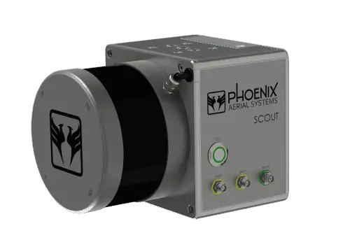
The Scout is an ideal solution for both new entrants and experienced firms looking to offer an aerial LiDAR solution for jobs considered too small for conventional LiDAR systems.

The Scout weighs 1.85kg (4 lbs), minimizing UAV power usage and maximizing flight time. At the core of the Scout is the Velodyne VLP-16 puck, which features 16 lasers spread out over a 30º vertical field of view, a 120 meter range and the ability to capture up to 300,000 measurements per second and up to 600,000 per second in dual return mode.

The Scout includes Phoenix Aerial’s proprietary software suite which allows the operator to view a high-definition 3D point cloud in real time and guarantees minimal data gaps as well as proper vegetation penetration.

In addition to LiDAR, the Scout also includes an RTK photogrammetry option, giving users the ability to deliver LiDAR plus industrial-grade RGB/NIR imagery data simultaneously. This combination of LiDAR and multispectral imagery makes the Scout a highly capable precision agriculture and forestry UAV mapping system.

Although designed for aerial use, the Scout can be quickly mounted to ground-vehicles or even used for hand-held mapping applications, adding to the versatility of the system.

Posted by Mike Ball Mike Ball is our resident technical editor here at Unmanned Systems Technology. Combining his passion for teaching, advanced engineering and all things unmanned, Mike keeps a watchful eye over everything related to the unmanned technical sector. With over 10 years’ experience in the unmanned field and a degree in engineering, Mike’s been heading up our technical team here for the last 8 years. Connect & Contact

Latest Articles

Most Read Articles on UST This Week

Here’s our round-up of the five most read articles on UnmannedSystemsTechnology.com this week

Jun 20, 2025
New AI Emission Detector for Autonomous Drones Enables Remote Methane Monitoring

Percepto has introduced an AI-powered emission detection system that combines autonomous drones and real-time analytics to streamline methane monitoring and regulatory compliance for oil and gas operators

Jun 20, 2025
CRP Technology Receives ISO 14001:2015 Environmental Certification for Additive Manufacturing

CRP Technology has obtained ISO 14001:2015 certification from DNV, covering its additive manufacturing processes and confirming alignment with international environmental management standards

Jun 20, 2025
Chess Dynamics Demonstrates Advanced AI Tracking in Challenging Field Trials

Chess Dynamics has demonstrated its advanced AI tracking technology in demanding multi-domain trials, showcasing reliable target tracking, classification and sensor performance in complex conditions

Jun 20, 2025
Marine Laboratory Advances Shallow Water Mapping with RIEGL Bathymetric LiDAR

Plymouth Marine Laboratory is advancing shallow water mapping using RIEGL's UAV-mounted bathymetric LiDAR, enabling high-resolution, low-impact environmental data collection and research

Jun 20, 2025
Evolito to Develop Electric Propulsion System in New Aerospace Collaboration

Evolito and VÆRIDION have partnered to develop electric propulsion technology for the Microliner aircraft, aiming to deliver improved propulsion efficiency and operational safety

Jun 19, 2025

Featured Content

Exail Showcases Integrated USV & AUV Operations in Collaborative Trial

Exail’s DriX USV and Ifremer’s Ulyx AUV were jointly deployed for the first time, demonstrating advanced cooperative capabilities in deep-sea exploration

Jun 19, 2025
HBK Updates RTK Service for Precise Positioning in Autonomous Systems

HBK has updated its SensorCloud RTK service, integrating with MicroStrain by HBK navigation systems to provide centimeter-level accuracy and simplified deployment for autonomous systems

Jun 17, 2025
MEMS DC Accelerometers from SDI Deliver Superior Performance for Unmanned Systems

SDI's MEMS DC accelerometers offer a robust solution for unmanned aerial, ground, and underwater vehicles, providing precise static and dynamic motion sensing, crucial for autonomous navigation, attitude feedback, and structural monitoring

Jun 12, 2025
Advancing Unmanned Systems Through Strategic Collaboration UST works with major OEMs to foster collaboration and increase engagement with SMEs, to accelerate innovation and drive unmanned systems capabilities forward.