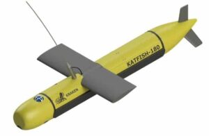
Kraken Announces KATFISH Sonar Platform

By Mike Ball / 23 Jul 2015

Smart Sourcing for Unmanned Systems

Discover cutting-edge solutions from leading global suppliers
SUPPLIER SPOTLIGHT
Follow UST

Kraken Sonar KATFISHKraken Sonar Inc., a developer of Synthetic Aperture Sonar (SAS) technology, has announced the development of KATFISH (Kraken Active Tow FISH), a sonar platform for military and commercial applications.

The primary objective of the KATFISH project is to develop an actively controlled, intelligent towfish as a platform for real-time ultra-high resolution seabed mapping system, based on Kraken’s Miniature Interferometric Synthetic Aperture Sonar (MINSAS) technology and Real-Time SAS Processing algorithms.

The KATFISH system is comprised of an actively controlled smart towfish, winch and handling subsystem and operator console. The winch and handling subsystem provides the capability to launch, tow, recover and stow the tow fish. The entire system is designed to be quickly installed and removed from craft of opportunity platforms and is packaged for easy transportation.

Conventional side scan systems are limited in that they only provide high resolution imagery at short range. KATFISH produces ultra-high resolution seabed imagery with constant resolution to full range. The additional information provided by KATFISH delivers a detection and classification capability that cannot be achieved with a conventional sidescan sonar.

KATFISH also generates highly accurate bathymetry data that is co-registered and geo-referenced to the same pixel grid co-ordinates as the imagery. Operators can produce crisp seabed imagery and detailed 3D digital terrain maps of seafloor topography that exceed IHO SP-44 survey standards.

The capability of generating centimeter-scale resolution in 3D also provides significant performance improvements in the detection, classification and identification of small seabed objects.

The KATFISH system also implements an innovative SAS gap filler transmitter that produces high resolution data in the nadir region. The system uses two rows of identical receiver elements to deliver bathymetry. An additional lower frequency transmit element, unique to KATFISH, provides a SAS resolution gap fill directly under the platform.

Sonar data is transferred from the transceiver to the processing unit via a Gigabit Ethernet network interface. The sonar operation is controlled from a graphical user interface (GUI) on a notebook computer. The operator sets the sonar parameters in the sonar control window, while depth, imagery and other sensor data are captured and displayed by Kraken’s INSIGHT application software.

KATFISH is currently under development and has successfully completed proof-of-concept sea trials. The system is now being commercialized with a series of planned technical milestones.

Posted by Mike Ball Mike Ball is our resident technical editor here at Unmanned Systems Technology. Combining his passion for teaching, advanced engineering and all things unmanned, Mike keeps a watchful eye over everything related to the unmanned technical sector. With over 10 years’ experience in the unmanned field and a degree in engineering, Mike’s been heading up our technical team here for the last 8 years. Connect & Contact

Latest Articles

Most Read Articles on UST This Week

Here’s our round-up of the five most read articles on UnmannedSystemsTechnology.com this week

Jun 13, 2025
Advanced Navigation’s Micro AUV Reveals Coral Bleaching at Remote Southern Reef

Using autonomous underwater technology, Advanced Navigation and O2 Marine have documented severe coral bleaching at Hall Bank, revealing climate impacts on one of Earth’s southernmost reefs

Jun 13, 2025
D-2 CTD Sensors Displayed at Combined Naval Event 2025

D-2 Inc. highlighted its latest underwater sensor technologies and mobile fuel testing system during Combined Naval Event 2025, held May 20–22 in Farnborough, UK

Jun 13, 2025
Deep Trekker ROVs Support Inland Demining Efforts

Deep Trekker has delivered sixteen REVOLUTION ROVs to the State Emergency Service of Ukraine, supporting underwater EOD missions through a UNDP initiative

Jun 13, 2025
Systork Launches Upgraded Linnet Mosaic-X5 GNSS Module

Systork introduces the Linnet Mosaic-X5, featuring enhanced thermal performance, microSD logging, and full GNSS support for drones and robotics in challenging environments

Jun 13, 2025
Wave Relay Devices Receive NSA Approval for Classified Communications

Persistent Systems’ Wave Relay® devices have received NSA approval for CSfC use, offering secure, commercial alternatives to legacy classified communication solutions

Jun 13, 2025

Featured Content

MEMS DC Accelerometers from SDI Deliver Superior Performance for Unmanned Systems

SDI's MEMS DC accelerometers offer a robust solution for unmanned aerial, ground, and underwater vehicles, providing precise static and dynamic motion sensing, crucial for autonomous navigation, attitude feedback, and structural monitoring

Jun 12, 2025
Calian GNSS Unveils New Anti-Jamming CRPA with XF+ Filtering

Calian GNSS has introduced the CR8894SXF+, a compact CRPA antenna with in-band null forming and XF+ filtering for resilient GNSS performance in interference-prone environments

Jun 06, 2025
Honeywell Introduces HG3900 Tactical-Grade IMU with Enhanced Sensor Accuracy

Honeywell has introduced the HG3900 IMU, a MEMS-based device with tactical-grade accuracy, offering significant SWaP advantages for precision navigation systems

Jun 05, 2025
Advancing Unmanned Systems Through Strategic Collaboration UST works with major OEMs to foster collaboration and increase engagement with SMEs, to accelerate innovation and drive unmanned systems capabilities forward.