Canadian Research Team Uses Drones to Map Flood Effects

By Mike Ball / 25 Jun 2015

Smart Sourcing for Unmanned Systems

Discover cutting-edge solutions from leading global suppliers
SUPPLIER SPOTLIGHT
Follow UST

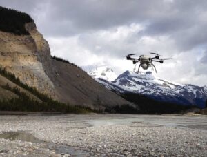
Drone at Alberta riverA team of researchers at the University of Calgary and the University of British Columbia has announced that it is using drones to examine the toll of the deluge on local rivers two years after Calgary and parts of southern Alberta suffered record-setting floods.

The study, which began three years ago, started out as a way to map fish habitats in the Elbow River using drone technology.

“We started out trying to see what we could measure in rivers using drones, but after the 2013 flood we ended up in a unique position of being able to measure the effects of the flood at an unprecedented level of detail,” says Chris Hugenholtz, Associate Professor and Cenovus Research Chair at the University of Calgary.

In a paper recently published online in The Earth Surface Processes and Landforms journal, the research team found that the flood completely restructured the flow of the Elbow River adjacent to Redwood Meadows.

“The magnitude of the change was catastrophic, such that parts of the river channel now looks nothing like it did before the flood,” said Aaron Tamminga, a PhD student at UBC and lead author on the paper.

Comparing before-and-after maps and 3D models, research revealed that almost three hectares of river bank was carved away by the flood along a one kilometer stretch of the Elbow River, with some banks receding up to 100 meters. Detailed images from the drone also showed that the flood both straightened and widened the river channel and completely re-structured the gravel bed.

Brett Eaton, Associate Professor at UBC, notes that the river bed became armoured by the flood as parts of the bed are now littered with meter-scale boulders. “When we simulate the 2013 flood conditions over the current configuration of the river, we find that the river bed is more stable, which means that it will take an even larger flood than the 2013 event to produce the same magnitude of change in the future.”

Over the course of the summer, Hugenholtz and his colleagues are ramping up efforts to measure the legacy of the 2013 flood on the Bow, Kananaskis and Elbow Rivers. They will also be looking at ways to integrate drones into a decision support framework for disaster management.

Posted by Mike Ball Mike Ball is our resident technical editor here at Unmanned Systems Technology. Combining his passion for teaching, advanced engineering and all things unmanned, Mike keeps a watchful eye over everything related to the unmanned technical sector. With over 10 years’ experience in the unmanned field and a degree in engineering, Mike’s been heading up our technical team here for the last 8 years. Connect & Contact

Latest Articles

SAE Media Group Releases Agenda for Counter UAS Middle East & Africa 2025

The inaugural Counter UAS Middle East & Africa 2025 will gather global defense leaders in Amman to explore threats, technologies, and strategies shaping regional drone defense

May 13, 2025
New Quartz Accelerometers for Industrial Applications Unveiled

Micro-Magic launches AC-6 quartz flexure accelerometers for demanding unmanned applications operating in high-temperature, high-vibration industrial environments

May 13, 2025
Advantages of Forward Looking Sonar: Q&A with FarSounder

Jake Palmer from FarSounder delves into the advantages of forward looking sonar, emerging trends, and highlights the environmental impact of their technology

May 13, 2025
GA-ASI’s Next Generation RPAS Meets Stringent Airworthiness Standards

The UK has certified the RAF’s Protector RG Mk1 UAS based on GA-ASI's MQ-9B, marking a major milestone in airworthiness for large, unmanned aircraft systems

May 13, 2025
CENTUM to Provide Signal Intelligence Systems for Maritime Drone Surveillance

Marine Instruments and CENTUM are collaborating to equip the M5D-Airfox drone with airborne signal intelligence, enhancing maritime surveillance and rescue missions

May 13, 2025
Textron Uncrewed Technologies Strengthen Littoral Combat Ship Operations

Learn how the integration of Aerosonde UAS and CUSV is transforming Littoral Combat Ship missions with enhanced versatility, autonomy, and operational reach

May 13, 2025

Featured Content

SAE Media Group Releases Agenda for Counter UAS Middle East & Africa 2025

The inaugural Counter UAS Middle East & Africa 2025 will gather global defense leaders in Amman to explore threats, technologies, and strategies shaping regional drone defense

May 13, 2025
New Tactical Grade IMU from Inertial Labs for UAVs & Guided Munitions

Inertial Labs has launched the IMU-H100, a compact, tactical-grade MEMS IMU designed to enhance precision navigation for UAVs and guided systems

May 08, 2025
Geolocation in GPS-Denied Environments Successfully Demonstrated

Trillium Engineering's GD-Loc, integrated with the HD55-MV gimbal on a Group 2 UAS, has successfully demonstrated sustained Category 1 geolocation accuracy within six meters, highlighting its critical advantage for precise ISR missions in GPS-denied environments

May 06, 2025
Advancing Unmanned Systems Through Strategic Collaboration UST works with major OEMs to foster collaboration and increase engagement with SMEs, to accelerate innovation and drive unmanned systems capabilities forward.