


Discover World-Leading Unmanned and Autonomous Technologies
Discover cutting-edge solutions from leading global suppliers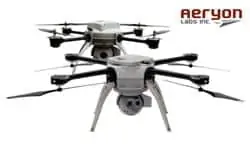
Aeryon Map Edition bundle includes a choice of Aeryon sUAS – Aeryon Scout or Aeryon SkyRanger
Aeryon Labs has introduced Map Edition bundles for the Aeryon small Unmanned Aerial Systems (UAS). This new bundled option, available for both the Aeryon Scout™ and Aeryon SkyRanger™, is designed for any application that requires survey-grade accuracy orthomosaics, Digital Surface Models (DSMs) and point clouds from aerial or oblique imagery – and seamless integration with GIS, CAD, and traditional photogrammetry software.
Aeryon Map Edition includes:
- Aeryon Scout or Aeryon SkyRanger sUAS
- Integrated imaging payload for image capture (according to sUAS model)
- Pix4Dmapper software to enable field and office image processing, including integrated tools for 3D output visualization and editing
“Aeryon is excited to support the new Pix4Dmapper software. Enhanced image processing and support for 3D visualization and editing add compelling functionality for our customers” explains Ian McDonald, VP Product & Marketing. “The new Map Edition bundles for the Aeryon Scout and Aeryon SkyRanger provide even more value by including the new Pix4Dmapper software. Aeryon Map Editions are a complete, easy-to-use, integrated survey and GIS solution for a wide range of commercial, public safety, and military applications.”
Pix4Dmapper aerial image processing software produces geo-referenced orthmosaics, DSMs and point clouds with survey-grade accuracy. The software includes innovative and fully integrated editing tools. Annotated objects and results can be seamlessly imported into any GIS or CAD software. Pix4Dmapper includes the rayCloud, an innovative concept combining the 3D point cloud with the original images for easy viewing as well as highly accurate semantic annotation and project improvement.
Pix4Dmapper’s automated workflow is intuitive and easy to use, and enables users to:
- Have full control over all tie points, calibration and results
- View, assess, edit and interpret results directly in the software
- Annotate and measure objects with the highest accuracy
- Use annotations to reprocess projects to improve the overall project accuracy
Visit http://www.aeryon.com for more information and to contact us about your aerial survey and GIS projects.


