


Discover World-Leading Unmanned and Autonomous Technologies
Discover cutting-edge solutions from leading global suppliers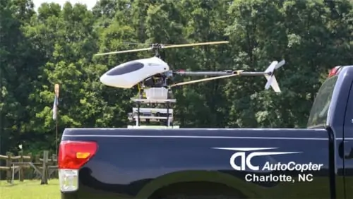
The AutoCopter™ is a UAV helicopter providing remote sensing of crops using three full-sized cameras (multi-spectral, DSLR and HD Video) while flying a GPS plan for over two hours without the need to refill fuel.
After landing the data is moved to the ground control station and processed and created into GeoTiff images to import directly into shape files for applicator scripts.
Donald Effren, President of AutoCopter™ Corp reported, “Now you can immediately import the data into Ag Leader SMS, John Deere Apex and SST Farm Management Programs. Everything (processing NDVI, GeoTiff – orthorectification & stitching) can be done in the field. The Patent-Pending solution offers real-time answers – No waiting, no outside vendors.”
The importance of current data, gathered and processed in house, helps to reduce inputs and increase yields. A current customer stated: “We flew for two weeks using a manned helicopter. We got more and better data in a usable format in 20 minutes with the AutoCopter™. Data in real time is invaluable.”
According to Effren, a grower with 1,250 acres said, “The reduced inputs and increased crop yield will pay for the AutoCopter™ in one year”. The AutoCopter™ is built in the USA and is perfect for crops of all kinds, vineyards, fruit and nut groves. The UAV helicopter solution for precision agriculture is operating now in the US and Europe.
AutoCopter™ is working with Crop Consultants, Growers, Large Co-ops and Ag Dealers. It is seeking Distributors in the US, South America, Canada and Australia.
The ability to see things not visible with the eye enhances Crop Scouting with immediate information. Differences in the field become easily distinguishable and the resulting increased output, reduced inputs and the ability to even out the fields, is all part of the benefits of this technology.
This precision engineered technology has been tested and proven in the fields of the USA and Europe. The UAV has auto take-off, auto land and GPS enabled autopilot to provide the same type of “autosteer” now found on most tractors in the fields. The AutoCopter™ provides the unique ability to stop and look at a problem and then continue on its “mission.” Re-fly the same pathways for comparison the next week, month or year.
The HD Video provides the ability to “see what the helicopter sees as it flies” with the live video-downlink as well as recording the flight for future reference. The DSLR images are geo-referenced and mosaicked after landing. The sub-inch resolution of the multi-spectral camera provides unequaled clarity of data to help create improve applications in the field. These NDVI images are also geo-referenced so any problem can be addressed the next day by walking out to the exact location.
The AutoCopter™ is a “drone for farming” with technology loaded to improve precision agriculture, scouting and crop yields. Stop, backup and examine, resume the mission as it records all of your flight – with “eyes in the sky.” Delivery time 3-4 weeks.


