VMU-2 UAVs Provide Battlefield Intel During Training Exercise

By Caroline Rees / 14 Feb 2013

Smart Sourcing for Unmanned Systems

Discover cutting-edge solutions from leading global suppliers
SUPPLIER SPOTLIGHT
Follow UST

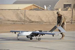
An RQ-7B Shadow UAV in Afghanistan (Photo by Sgt. Eric D. Warren)

Marine Unmanned Aerial Vehicle Squadron Two (VMU-2) provided infantry with timely intelligence during recent training exercises at Camp Lejeune.

VMU-2, with the RQ-7B Shadow, practiced providing the infantry with near real-time full motion video increased communications capabilities. With a constant stream of information from UAVs, ground commanders can react quickly to previously unseen threats and move decisively against targets of opportunity.

The battalion was training in convoy operations and clearing urban terrain during an exercise in preparation for their upcoming deployment with the Black Sea Rotational Force.

“Having an eye in the sky helps the ground decision makers because it increases their situational awareness on the battlefield,” said Capt. Darrel Prestesater, a forward air controller with 2nd Bn., 2nd Marines.
A battalion often has their own small unmanned aerial systems, but the VMU brings a more capable platform with longer loiter capability via the RQ-7B Shadow.

“As far as the ground forces themselves, the battalions typically have an RQ-11 Raven or a Wasp, which is a small, hand-launched unmanned aerial system,” said Capt. Steven P. Rogers, the adjutant for VMU-2. “They’re pretty small, low-altitude, and are light weight, so they have small cameras.”

The Shadow flies much higher and can zoom in on potential targets with a powerful camera. It can also laser designate to guide smart munitions fired either from aircraft or artillery. In a deployed environment, authorized personnel can get near real-time footage and communicate with the unmanned aircraft commanders by instant messaging or through more conventional means.

Adding to the capabilities of the system, the squadron set up a “spoke” at Camp Lejeune near the battalion’s training area. The spoke is a command center set up at a separate location from the main VMU-2 location, which extends the operational range of the aircraft. Controllers at Cherry Point flew the aircraft from the launch site to an area both the Cherry Point operators and the spoke operators could control the aircraft, where it was handed off to the spoke.

“It increases situational awareness,” said Rogers. “You take Afghanistan for example, and anybody who can (connect to the network) could pull up a nearly real-time full-motion video feed. So if someone at Leatherneck wants to see what’s going on at Combat Outpost Payne, they plug in (to the network) and see what’s going on. It’s a very effective force multiplier.”

By Cpl. Scott L. Tomaszycki, U.S. Marine Corps

Posted by Caroline Rees Caroline co-founded Unmanned Systems Technology and has been at the forefront of the business ever since. With a Masters Degree in marketing Caroline has her finger on the pulse of all things unmanned and is committed to showcasing the very latest in unmanned technical innovation. Connect & Contact

Latest Articles

High-Energy Density Batteries for Drones & Robotic Vehicles

The SCIO Brick® platform offers industry-leading energy density in a compact and lightweight footprint, and can be scaled to meet high-voltage requirements

Jul 12, 2025
Most Read Articles on UST This Week

Here’s our round-up of the five most read articles on UnmannedSystemsTechnology.com this week

Jul 11, 2025
Vertiq Speed Firmware v0.1.1 Now Available with Bug Fixes

Vertiq has released firmware v0.1.1 to correct a parameter bug affecting telemetry and 3D mode settings on select G1 and G2 modules

Jul 11, 2025
The Role of ROVs in Unmanned Marine Operations

Oceanbotics has answered the most common questions about ROVs, covering how they work, where they're used, and key capabilities

Jul 11, 2025
LiveU File Transfer Speeds Up Drone Data Delivery for Critical Missions

LiveU’s File Transfer enables rapid transmission of large drone data files, reducing delays and supporting faster decision-making in public safety and infrastructure operations.

Jul 11, 2025
Exploring Differences Between M9PLUS & M9 GNSS Antennas

Discover the key upgrades in Maxtena’s new M9PLUS GNSS antenna, including improved performance, signal purity, and multipath mitigation over the original M9

Jul 11, 2025

Featured Content

USAF Uses Inertial Labs Drone Lidar for Tree Obstruction Survey

The US Air Force successfully used Inertial Labs drone Lidar and cloud software to quickly map tree obstructions at Joint Base Lewis-McChord (JBLM), improving airfield safety

Jul 11, 2025
New UAV to Combine Solar Hydrogen & Battery Power for Extended Flight

XSun and H3 Dynamics are developing the first UAV powered by solar, hydrogen, and batteries, aiming to deliver zero-emission, long-endurance unmanned flight

Jul 07, 2025
Enhancing Mangrove Restoration Through 3D Printed Drone Design

Explore how Inverto Earth, in collaboration with HP Additive, is using sustainable 3D printing and drone technology to drive large-scale mangrove restoration and protect vulnerable coastal ecosystems

Jul 03, 2025
Advancing Unmanned Systems Through Strategic Collaboration UST works with major OEMs to foster collaboration and increase engagement with SMEs, to accelerate innovation and drive unmanned systems capabilities forward.