Teledyne Geospatial Aids Study of Submarine Impacts of Tongan Volcanic Eruption

Software provided by Teledyne CARIS was used to monitor data quality and coverage, with new data being compared to previous maps to assess the effects of the eruption on marine life and seafloor composition By Caroline Rees / 13 Oct 2022

Environmental Monitoring Sensors and Software

Discover cutting-edge solutions from 11 leading global suppliers
SUPPLIER SPOTLIGHT
Follow UST
Teledyne CARIS - TESMaP
Aerial view of HT-HH, showing new multibeam depth data overlaid on a satellite image

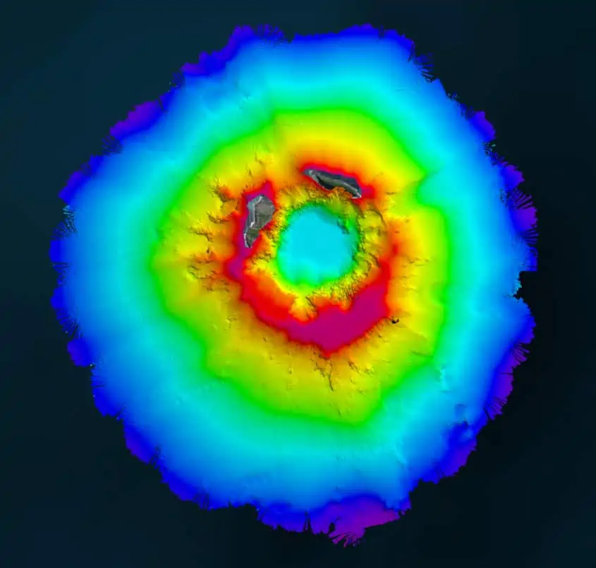
Teledyne Geospatial is proud to have partnered with Seabed 2030 in the Tonga Eruption Seabed Mapping Project (TESMap).

In April 2022, New Zealand’s National Institute of Water and Atmospheric Research (NIWA) and The Nippon Foundation announced a mission to discover the undersea impacts of the Hunga-Tonga Hunga-Ha’apai (HT–HH) volcanic eruption, which produced the biggest atmospheric explosion recorded on Earth in over a century. 

Supported by The Nippon Foundation-GEBCO Seabed 2030 Project, TESMaP had two phases, led by NIWA: phase one saw scientists survey the area around the volcano with RV Tangaroa. As part of phase two, SEA-KIT International’s Uncrewed Surface Vessel (USV) Maxlimer was used to conduct further mapping inside the caldera.

For the duration of TESMaP, Seabed 2030 and Nippon Foundation-GEBCO Ocean Mapping Fellows utilized software provided by Teledyne CARIS—a Seabed 2030 partner with over 40 years of experience in developing hydrographic and marine geospatial software. 

The software was integral to the project as they facilitated the monitoring of data quality and coverage, with new data being used for comparative studies against previous maps to assess the effects of the eruption on marine life and seafloor composition. Software provided by Teledyne CARIS will also be used to process the data to generate the final products.

“As the leading developer of hydrographic and marine GIS software, Teledyne CARIS’ contribution to TESMaP has been invaluable,” said Seabed 2030 Project Director Jamie McMichael-Phillips. “We are grateful for the provision of this software which has truly been a force multiplier in processing data as part of scientific research—and ultimately—our understanding of the ocean.”

“We are passionate about delivering products that assist in the provision of meaningful, actionable data,” said Karen Cove, Director of Products, Teledyne CARIS. “Our partnership with Seabed 2030 and support of TESMaP underscores our commitment to the ocean environment and engaging in projects pursuing greater understanding.”

Posted by Caroline Rees Caroline co-founded Unmanned Systems Technology and has been at the forefront of the business ever since. With a Masters Degree in marketing Caroline has her finger on the pulse of all things unmanned and is committed to showcasing the very latest in unmanned technical innovation. Connect & Contact

Latest Articles

Precision RTK GNSS Positioning for UAVs & Unmanned Systems

RTKdata provides access to a world-leading RTK corrections data network with over 12,000 base stations in more than 140 countries

Mar 27, 2025
WOLF Introduces New VPX Modules with High-Performance Blackwell GPUs

WOLF Advanced Technology has unveiled new 3U and 6U VPX modules featuring NVIDIA Blackwell GPUs, offering high-performance AI computing for rugged systems

Mar 27, 2025
Volatus Expands Medical Delivery Network with Long-Range Drone

Volatus Aerospace is expanding its medical delivery network by integrating RigiTech’s Eiger long-range delivery drone, allowing for extended reach across Canada and underserved regions

Mar 27, 2025
Ruggedizing Products Built for Extreme Conditions with Conformal Coatings

Specialty Coating Systems discusses Parylene conformal coatings and how they can advance the ruggedization of products in environmentally challenging settings

Mar 27, 2025
Enhancing EO/IR Imaging Performance with Velox

Velox outlines the advantages of its compact EO/IR imaging system that delivers stabilized, high-resolution performance for defense, security, and industrial surveillance applications

Mar 27, 2025
Submersible Captures First Sighting of Prickly Shark in French Polynesia

SubC Imaging's latest case study outlines how its 1Cam Mk6 deep-sea camera, mounted on the SEAmagine Aurora submersible, captured a sighting of a prickly shark in French Polynesia

Mar 27, 2025

Featured Content

Be Part of the World’s Largest Business Accelerator for Uncrewed Systems: Applications Now Open

GENIUS NY, a drone and robotics accelerator program, is now accepting applications from tech startups focused on uncrewed aerial systems, to automation and Advanced Air Mobility (AAM)

Mar 25, 2025
How IONA Reaches the Last Mile Through Smart Product Development

In this webinar, learn from Drone Industry Insights about scaling production and supply chain challenges, strategies from Arena by PTC to optimize product development, and how IONA Drones are advancing last-mile delivery

Mar 18, 2025
Nokia Talks to UST about 4G/5G Connected Drone-in-a-Box Advancements

How Nokia is revolutionizing drone connectivity with 4G and 5G, and advancing autonomous operations with the cutting-edge drone-in-a-box solution; Nokia Drone Networks

Mar 16, 2025
Advancing Unmanned Systems Through Strategic Collaboration UST works with major OEMs to foster collaboration and increase engagement with SMEs, to accelerate innovation and drive unmanned systems capabilities forward.