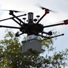
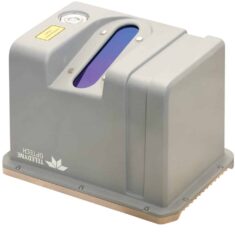
The CL-90 is a compact survey-grade LiDAR sensor designed for OEMs and system integrators of UAVs.
Available in a low-SWaP transceiver form factor, it can be easily integrated with a wide variety of drone platforms as well as third party inertial navigation systems (INS) and image sensors.
Featuring superior vegetation penetration and unparalleled data precision, the CL-90 is ideal for surveying in complex environments with extremely tight tolerance and low noise requirements. A unique 90-degree maximum programmable field of view (FOV) allows you to balance point density against range for maximum application flexibility and high performance even at the limits of UAS flight ceilings.
The sensor is available as a kit bundled together with an Ethernet cable, a power and control cable, and an integrator data package that includes post-processing software and real-time control and processing libraries.
The CL-90 is highly suited to a wide range of UAV survey applications, including:
- 360 Field of View for forestry and precision agriculture
- Long Range LiDAR for mapping powerlines, utilities and transport corridors
- Compact LiDAR for Stockpile and open-pit mining
- Drone monitoring and inspection of construction sites
- Survey LiDAR for Archaeological exploration
| Dimensions (LxWxH) | 300 x 213 x 209 mm |
| Weight | 4.1 kg |
| Range Performance | 176 m (500 kHz) to 633 m (50 kHz) |
| Pulse Repetition Frequency | 500, 200, 50 kHz (Programmable) |
| Beam Divergence | 0.3 mrad |
| Wavelength | 1550 nm |
| Range Accuracy (1 sigma) | 10 mm |
| Single-Shot Precision | 5 mm |
| Scan Angle (FOV) | 64-90° |
| Lines Per Second | 20 – 52 lines/sec (10-26 Hz) |


