


YellowScan, a global leader and designer of next generation of UAV LIDAR solutions, has announced the release of its new software add-on module: Terrain.
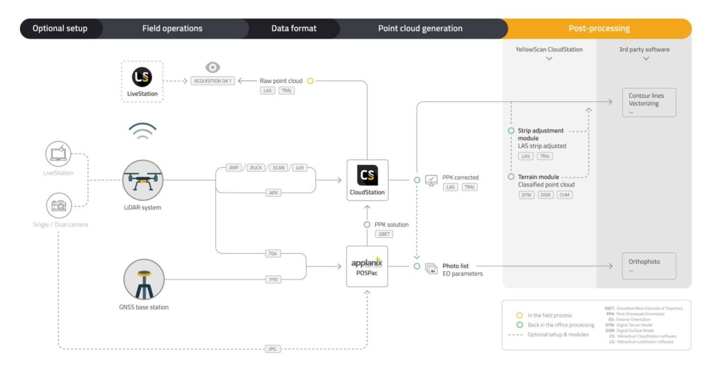
This new module enhances the processing power of CloudStation, YellowScan’s powerful data processing tool that provides users the ability to create and manipulate point cloud data from LiDAR missions. It enables the extraction, processing and display of data immediately after acquisition, providing the ability to program the auto-generation of flight lines and export .LAS files in just a few clicks. The pilot can also visualize the result of the classification and select which classification class to visualize (unclassified, ground, other).
 The new Terrain module simplifies the experience of extracting classified point cloud, making it easier to process flight data and save time. The key business benefits are:
A simplified classification process
The addition of Terrain increases the effectiveness of CloudStation by allowing for the automatic classification of points as “ground/non-ground”. This enables the user to select a “preset profile” based on the type of terrain the YellowScan LiDAR solution is being flown in such as mountain, forest, or cliff.
A data extraction made in just 1 click
Terrain offers several additional export format types of data. The user can export classified LAS or digital models such as DSM (Digital Surface Model), DTM (Digital Terrain Model) and DHM (Digital Height Model) as GeoTIFF (geolocalized TIFF).
This new module will allow CloudStation to generate a hillshade for Digital Terrain Models (DTM), making it easier to visualize and better understand the level of detail observed from flight data.
Tristan Allouis, Chief Technical officer at YellowScan explains; “The Terrain module was developed to answer our customer’s needs to have a tool that can easily and automatically classify LiDAR point cloud and generate bare earth models”.
Trimtec’s Petter Hoffmann added, “The Terrian module is working quite smooth, helping process data in the field fairly quickly thus giving our team more time to analysis the output and counsel our customers”.
CloudStation and its modules, Strip Adjustment and Terrain, are already available with the acquisition of YellowScan LiDAR solutions.


