Drone telemetry is data gathered about the aircraft and its surroundings that is sent back to the operator or ground control station (GCS). This information may be taken from the drone’s autopilot, sensors such as accelerometers, gyroscopes and GPS, or from subsystems such as the aircraft’s power source.
Tracking Telemetry

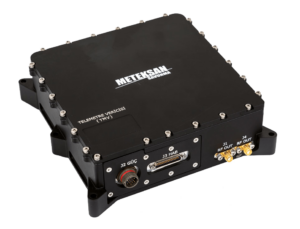
TMV Telemetry Transmitter by Meteksan
Telemetry data provides the ability to track UAV status in real time, allowing pilots to monitor position, attitude and altitude to ensure smooth and efficient flight. Depending on the sensors installed on board, it may also provide information on components and subsystems such as the RPM of the rotors and the voltage level of the batteries.
Drone telemetry data is transmitted via radio, often on a separate link to the drone control signals to provide increased safety. This requires the drone to have an onboard radio transmitter as well as a receiver, and appropriate antennas. Common drone radio telemetry frequencies include 433 MHz, 915 Mhz and the newer 2.4 GHz. Wireless telemetry data can also be transmitted via Wi-Fi and LTE networks such as 4G and 5G, which typically have a shorter range than other radio technologies but provides higher data rates.

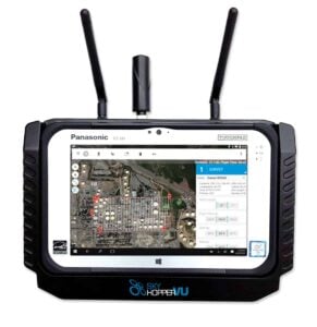
VU Telemetry Viewer by SkyHopper
FPV Telemetry
Another form of telemetry is FPV (first-person view), in which a video feed from an onboard camera is transmitted back to the drone pilot and displayed on a monitor or a pair of FPV goggles. This allows the pilot to see exactly what the drone “sees”, and in good communication environments, can provide a unique form of real-time situational awareness.
Marine & Subsea Telemetry
Telemetry transmission may also be utilised by marine and subsea systems such as ROVs (remotely operated vehicles) and AUVs (autonomous underwater vehicles) and is usually transmitted via acoustic methods due to the inability of radio waves to propagate underwater.


