


CHC Navigation has launched the LT60H, an advanced rugged smartphone tailored for high-precision GIS data collection and outdoor operations. Featuring a survey-grade GNSS positioning module, rugged IP67-rated construction, and a sunlight-readable display, the LT60H ensures reliable centimeter-level positioning accuracy even in harsh environments.
The LT60H integrates a high-performance GNSS positioning module that supports GPS, GLONASS, Galileo and BeiDou constellations. With 1408 GNSS channels, a quadrifilar helix antenna, and full GNSS RTK network correction support, the LT60H achieves centimeter- to decimeter-level accuracy even in challenging conditions.
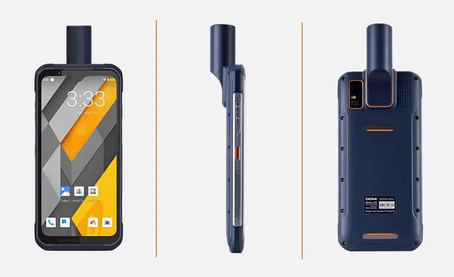
Running on Android 12, the LT60H includes 4G, WiFi, Bluetooth 5.1, and NFC wireless technologies for robust connectivity. Designed for seamless compatibility with third-party data collection apps, the LT60H enables field crews to accurately capture locations, photos, videos, measurements, and other geospatial data. The LT60H features an HD screen with over 400 DPI and 550 cd/㎡ for exceptional clarity and detail, even in sunlight. Its 5-point capacitive touch screen supports data capture with a stylus, gloves, or wet hands to accommodate a variety of operating conditions.
The LT60H rugged GNSS RTK smartphone is an all-in-one solution to boost productivity for site layout and surveying, GIS data collection, utility asset management and other applications that require high-precision location data.
The LT60H industrial-grade IP67 design ensures resistance to dust, shock, vibration, drops, water immersion and extreme temperatures. It can withstand a drop to concrete from up to 1.5 meters, ensuring data integrity in the event of an accidental drop. Its 6.3-inch Gorilla Glass display combines durability with excellent sunlight readability. With a 6000 mAh battery, the LT60H provides up to 8 hours of operation on a single charge.
Sans Ma, Product Manager at CHC Navigation, commented: “The LT60H is a major upgrade in handheld data collection for surveyors, construction crews, asset managers, and any profession that relies on geospatial accuracy. Its rugged design, integrated high-precision GNSS technology and powerful hardware make the LT60H the ultimate tool for increasing the efficiency of a mobile workforce.”


