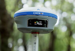
 CHC Navigation (CHCNAV) has launched the i93, a smart GNSS receiver that includes an IMU and dual cameras for centimeter-accuracy surveying. Featuring 3D visual staking feature for enhanced efficiency and ease of use, the i93 can be used to augment UAV (unmanned aerial vehicle) surveys with ground-based imagery.
The i93 GNSS receiver combines CHCNAV’s proprietary iStar technology with an integrated 1408-channel RF-SoC processor for optimized use of all GNSS constellations and frequencies. These new technologies improve GNSS data quality and tracking capabilities by more than 20 percent, enhancing GNSS RTK performance in challenging environments and delivering reliable and accurate positioning data.
The integrated Starlight cameras provide immersive 3D visual navigation. Based on powerful image processing technology, the cameras paired with the controller offer a unique way for surveyors to capture precise coordinates in real time. Field operators simply follow the 3D directional arrow and distance on the controller in real-time to stake out points. The 3D visual guidance is also available for line and CAD map staking in LandStar software, making surveying easy, intuitive, and efficient.
The Auto IMU feature eliminates the need for manual initialization and complex procedures. CHCNAV’s Auto-IMU 200 Hz pole-tilt compensation automatically maintains maximum accuracy, allowing the pole to be carried over the shoulder, held in hand, or placed horizontally, as you move from point to point on the job site.
Rachel Wang, Product Manager of CHCNAV’s Surveying and Engineering Division, commented: “The innovative visual positioning simplifies point measurement and facilitates surveying in hard-to-reach or hazardous areas. In addition, the i93 can be used to augment aerial surveys generated from oblique imagery with ground-based images, as its data is fully compatible with the most popular 3D modeling software. The i93 takes GNSS surveying to the next level by merging the best of GNSS, IMU, and 3D imaging into a single antenna.”


