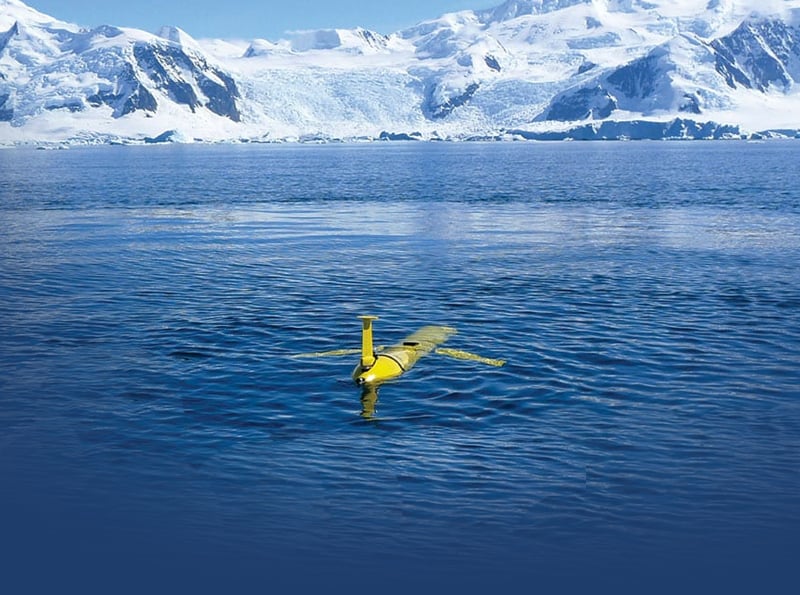
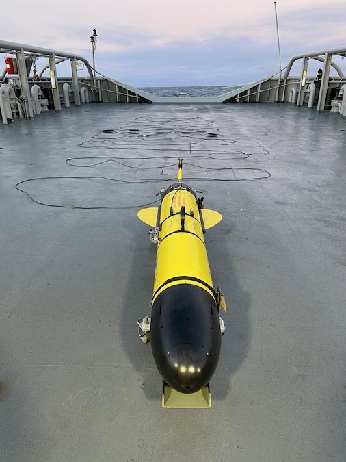
An autonomous underwater glider developed by Teledyne Marine and Rutgers University has begun a world-first mission to circumnavigate the globe, marking a major milestone in long-endurance unmanned ocean exploration.
The near five-year Sentinel Mission departed on 10 October 2025, following a ceremony at the Woods Hole Oceanographic Institution (WHOI). The mission will use Teledyne’s ‘Redwing’, a next-generation Slocum Sentinel Glider, launched from the edge of the continental shelf south of Martha’s Vineyard, Massachusetts. The vehicle is specifically built for endurance, designed for ultra-long missions, and is thought to bethe most advanced commercial subsea glider ever developed.
The glider will gather advanced levels of data on ocean currents, sea temperature, and their impact on weather systems and the planet. This data is intended to help refine weather models, improve hurricane intensity forecasting, and inform ocean policy and conservation efforts.
Brian Maguire, COO at Teledyne Marine, commented, “This is a truly historic mission. It will pave the way for a future where a global fleet of autonomous underwater gliders will be able to continuously sample our oceans. These gliders will deliver early warnings of extreme weather and will track the impact of shifting ocean currents so that we can refine long-term weather projections in a way that scientists have dreamed of for decades.
“It will also prove that long-range, next-generation, low energy autonomous underwater vehicles (AUVs) are capable of carrying more complex, heavier, and increasingly energy hungry sensors on missions that we could only have imagined previously.”
The ‘Redwing’ is an acronym for Research & Education Doug Webb Inter-National Glider, a tribute to glider inventor Doug Webb, who pioneered autonomous ocean vehicles at Teledyne Webb Research and passed away in 2024. The glider will surf global ocean currents, gathering critical ocean data from under-sampled, remote regions of the globe.
Global Flight Path & Data Collection
The glider’s estimated 73,000-kilometre journey will be undertaken in several legs. Redwing’s first leg will see it ride the Gulf Stream south of Martha’s Vineyard toward Europe, before sweeping south to stop at Gran Canaria off the coast of North West Africa. Its next leg will take it to Cape Town in South Africa, before crossing the Indian Ocean to stop at Perth in Western Australia, then on to Wellington, New Zealand. It will then navigate the Antarctic Circumpolar Current — its longest leg — to the Falkland Islands. From here, possible stops include Brazil and the Caribbean before heading back to Cape Cod in the U.S.
When the glider surfaces every 8–12 hours, it will transmit information via satellite, sharing vital data on ocean temperature, salinity, currents, and ocean health via the National Oceanic and Atmospheric Administration’s (NOAA) global monitoring system. This will make real-time results internationally accessible to scientists, oceanographers, meteorologists, universities, and schools worldwide.
Glider Engineering and Sensors
The Sentinel Redwing is a new class of sea glider, specially engineered with extended battery capacity, capable of travelling up to 15,000 kilometres on a single leg. It will dive to depths of 1,000 metres before returning to the surface to transmit data. Using only gravity and buoyancy for propulsion, it conserves energy for years-long deployments by “flying” in a sawtooth pattern through the water. Its smart design allows it to “surf” ocean currents, travelling at an average speed of 0.75–1 knots.
The glider measures 2.57m long and 0.33m in diameter, carrying a payload of up to 3.5kg. This payload includes:
- A CTD sensor (conductivity, temperature, depth/density).
- An altimeter to avoid the seafloor.
- Attitude and compass sensors for navigation.
- A fish monitor from Dalhousie University, which tracks tagged marine life such as sharks and whales.
Shea Quinn, Sentinel Mission Project Lead and Slocum Glider Product Line Manager, notes that the data gathered will include pings from tagged marine life, water temperature, and density. “As we travel through the layers of the ocean, which move over and under each other in different directions, we’ll gather data on water temperature and density, and we’ll pick up pings from tagged marine life. “We’ll be able to see what’s happening at the surface and deeper underwater where huge patches of cold water and warm water move.
“This data will help us to show, for example, where a hurricane is going to go next and how intense it’s going to be. We’ll also build a better knowledge about the impact of ocean currents on our weather patterns, informing global ocean models of the future, and our understanding of long-term climate change.”
Teledyne Marine engineers are working closely with more than 50 Rutgers University students at the Center for Ocean Observing Leadership (COOL), who helped program the navigation software. This international undertaking is supported by partners from Spain, Gran Canaria, South Africa, Australia, New Zealand, Brazil, the UK, and the U.S.
Scott Glenn, Distinguished Professor at Rutgers, stated, “This is a pivotal moment for ocean science. We’re deploying an autonomous glider that will travel the world’s oceans, gathering data. And we’re doing it with students, educators and international collaborators every step of the way. Fittingly, it will also realise a piece of science-fiction written by Henry Strommel of Woods Hole Oceanographic Institution that appeared in Oceanography Magazine in 1989. This foresaw an international race between three Slocumb Sentinel gliders to circumnavigate the globe first, and a time when there would be a fleet of underwater gliders taking part in missions around the world.”
Updates on the Sentinel Mission’s progress can be found on the Teledyne Marine website >>