


eVTOL Drones
Discover cutting-edge solutions from 15 leading global suppliers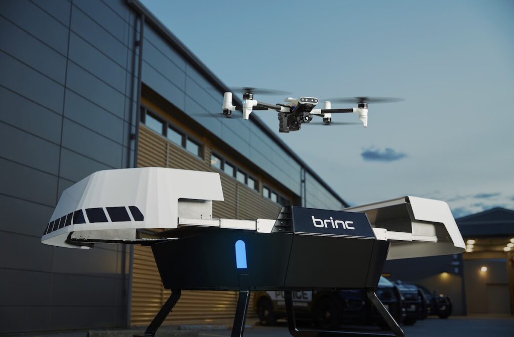
BRINC has released its new purpose-built hardware designed for Drone as First Responder (DFR) operations, the Responder drone and Responder Station charging nest.
The new drone platform and docking station are set to enable city-wide drone as first responder deployments. The drones are engineered to reach 911 calls in under 70 seconds, providing critical situational awareness to first responders before they arrive on scene.
They are also capable of delivering life-saving medical supplies, reducing manned response times, and addressing low-priority calls without the need to dispatch personnel.
BRINC state that as municipalities experience police staffing shortages, its DFR solution can resolve approximately 25% of calls for service without dispatching officers.
Responder
BRINC’s American-made Responder drone can support first responders as part of an agency’s automated DFR system, a patrol-led DFR approach, or as a manually deployed drone.
The Responder can also function as a medical drone, delivering a wide selection of life-saving payloads. This includes supplies such as EpiPens, automated external defibrillators (AEDs), personal floatation devices (PFDs), and naloxone (Narcan). Its two-way communication capability also facilitates instruction, and can enhance de-escalation during tense confrontations.
Responder is equipped with a remarkable camera payload, providing a detailed view to public safety personnel once it arrives on-scene. It features a Full HD, 40x zoom visual camera array, and a 640px thermal sensor. The thermal imager can assist firefighters in identifying hotspots during structure fires, and help search and rescue teams locate missing or injured individuals.
Responder also has an emergency response vehicle livery, custom agency markings, red and blue lights, and an integrated siren to make it identifiable as a public safety asset.

Responder Station – Charging Nest
Complementing the Responder is the Responder Station, a robotic charging nest designed to be placed throughout communities for fast response times. Responder Station ensures that Responders remain operational, protected from weather, and ready to deploy at a moment’s notice. Together, the Responder and Responder Station enable sub-5-second drone deployment.
Responder drones return to the nearest available Station after the completion of each mission to charge from 0 to 100% in just 40 minutes.
BRINC LiveOps: Unified Drone Operations Software
The Responder DFR solution is driven by BRINC LiveOps, a drone operations software platform available on all modern web browsers. This allows for easy access on mobile devices, tablets, mobile data computers, and at real-time crime centers.
LiveOps provides:
Teleoperations: Fly Responder drones from anywhere in the world on a browser tab, using a computer’s arrow keys.
Manage District-Wide Deployments: View calls for service and available drones, select a station to launch from, and quickly deploy drones to emergencies.
2-Way Communications: Provide life-saving instruction and de-escalate critical situations.
Augmented Reality Overlays: Contextualize live feeds by overlaying map data on drone video feeds.
Integrated Airspace Awareness: View local weather information, ADS-B data, ground-based radar detections, FAA map tiles, and more to deconflict airspace.
Transparency Portal: Provide communities with flight logs and a program dashboard to promote transparency.
Integrate with Existing Public Safety Infrastructure: Connect with existing computer-aided dispatch (CAD), digital evidence management systems (DEMS), 911 call systems, and more.
The company has a strong history of serving public safety agencies across the United States. More than 500 agencies already use BRINC devices such as the LEMUR 2 or BRINC Ball, and over 150 agencies are moving towards city-wide 911 response drone deployments with BRINC, with four signed to begin BRINC DFR programs by the end of this year.
Don Redmond, BRINC Vice President of Advanced Public Safety Projects, commented; “Our fully integrated approach with Responder, Responder Station, and BRINC LiveOps sets us apart in the industry, enabling seamless coordination and rapid response in times of crisis. We anticipate that our innovative solution will not only enhance operational efficiency, but save lives.”
Blake Resnick, BRINC Founder & CEO, added; “The launch of BRINC DFR marks a pivotal moment in the evolution of emergency response. Our DFR initiative is set to revolutionize the public safety landscape by empowering first responders with capabilities that significantly improve emergency response times and outcomes.”


