GNSS/INS (GNSS-Aided INS)
Discover cutting-edge solutions from 10 leading global suppliers
Parker LORD has released the following article that outlines the benefits of using a GNSS-aided INS (inertial navigation system), such as the company’s tactical-grade dual antenna 3DMGQ7, over a pure GNSS navigation system.
A common challenge in selecting a navigation device is deciding between a traditional GNSS positioning system, or a combined GNSS/inertial navigation system. A GNSS/INS offers several benefits over a pure GNSS receiver, which may need to be balanced with an increase in cost, size and system complexity.
The main benefits of using a GNSS/INS, such as the 3DMGQ7, include:
Data output rates: Most GNSS receivers can output position data at relatively low rates, generally in the 5-20Hz range. An INS can rapidly integrate inertial data, which allows for an increase in data output rate. In the 3DMGQ7, the Extended Kalman Filter outputs a navigation solution at a maximum rate of 1000Hz. In applications with high rate control loops or highly dynamic motion, such as UAVs (unmanned aerial vehicles), data output rate is critical for performance.
Attitude data: A traditional GNSS system only has the ability to output position and velocity data. The addition of inertial sensors adds pitch, roll and yaw to the navigation solution. In many navigation applications, such as quadcopters and legged UGVs (unmanned ground vehicles), attitude data is required for balance and stabilization.
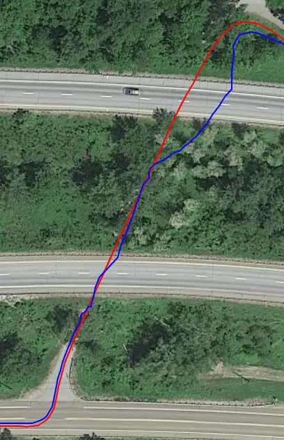
GNSS outages: One of the greatest benefits of an INS is the ability to operate in GNSS-denied environments. Without satellite coverage and a clear view of the sky, a GNSS system quickly loses the ability to estimate position. The following figure shows a comparison between the 3DMGQ7 INS position (red) and pure GNSS position (blue) while going through a set of tunnels. The GNSS solution quickly starts to diverge from the travelled path, while the INS solution tracks the road perfectly.