Belgian company Agilica BV has completed a feasibility study funded by the European Space Agency (ESA) to advance autonomous drone landing technologies in environments where GPS and other GNSS signals are unavailable or unreliable.
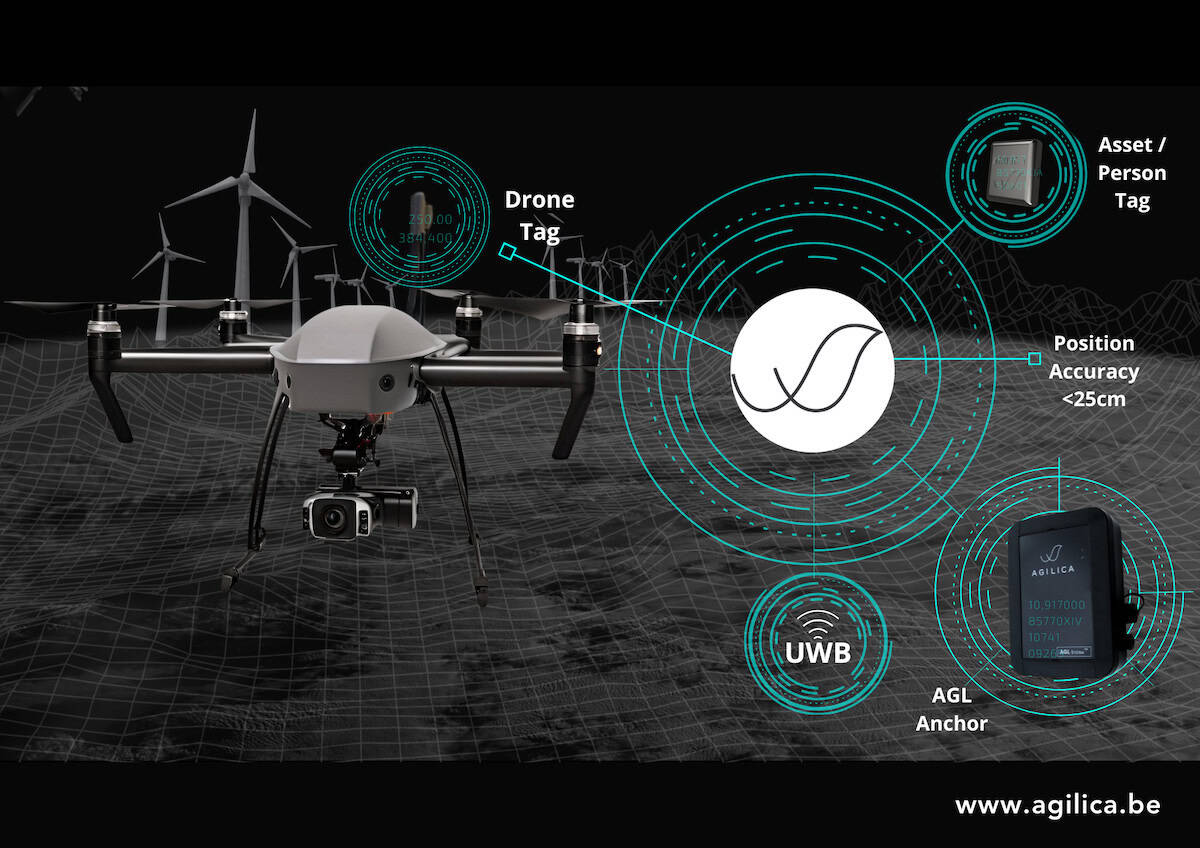
The study supports the development of Agilica’s core innovation, the AGL system, which combines Ultra Wideband (UWB) positioning with integrated support for GNSS and Galileo High Accuracy Service (HAS).
Bart Scheers, Agilica’s COO and lead on the project, said, “Landing a drone on a moving ship in dynamic conditions is one of the toughest challenges in drone autonomy. Our AGL system is built to solve this — not by replacing GNSS, but by augmenting it. This feasibility study confirms that our patented UWB approach can extend PNT services, with sub-20 cm precision in GNSS-denied zones.”
The AGL system is designed to enable precise drone navigation and landing in challenging conditions such as indoor spaces, offshore platforms, moving vessels, and dense urban settings. By incorporating GNSS receivers into the ground infrastructure, the system enables a seamless transition between satellite navigation and UWB-based positioning. This hybrid architecture supports continuity of navigation for UAVs operating in areas where satellite signal degradation, obstruction, or spoofing may occur.
Built on patented time of flight UWB technology, the AGL system operates like a terrestrial alternative to GNSS, delivering centimeter-level accuracy in environments that are metallic, enclosed, weather-affected, or otherwise unsuitable for vision-based navigation. Ground-based anchors equipped with GNSS receivers and precision timing components provide a stable reference framework, while compact mobile tags on UAVs enable autonomous, high-precision landings in conditions that typically defeat conventional systems.
The ESA-funded study validated both the technical and commercial feasibility of the AGL system. Key outcomes include:
- Successful demonstration of seamless transitions between GNSS and UWB-based positioning in collaboration with stakeholders from drone logistics, offshore energy, and advanced air mobility sectors.
- Identification of global market opportunities exceeding €1.9 billion.
- Development of a commercial roadmap focused on interoperability with drone service providers, OEMs, and infrastructure partners.
Hafeez, CEO of Agilica, said, “ESA’s support was pivotal in testing and expanding the limits of our core technology and understanding where it can deliver the most impact. This is about more than navigation — it’s about unlocking autonomy in the hardest places to reach and giving drone operators the confidence to scale critical services.”
Bart Scheers added, “We are entering a new phase — demonstrating not only the precision of our system, but how it fits into real-world logistics and mobility services. From drone ports to offshore wind farms, the need for robust APNT is universal.”
With feasibility established, Agilica is now preparing for live demonstration projects in partnership with drone manufacturers, logistics operators, AAM and eVTOL companies, and maritime autonomy developers. These pilot programs will showcase the robustness of the GNSS-to-UWB transition and evaluate system integration with commercial platforms and services.
By enhancing positioning resilience and landing autonomy, the AGL system is positioned to unlock new capabilities in UAV operations where satellite navigation alone cannot deliver.