Precision Positioning for Autonomous Driving

Bynav's X1 GNSS/INS receiver has provided high-precision positioning for the BrightDrive autonomous driving team which took second place in the Dubai Autonomous Driving Competition By Sarah Simpson / 26 Feb 2024

GNSS/INS (GNSS-Aided INS)

Discover cutting-edge solutions from 10 leading global suppliers
SUPPLIER SPOTLIGHT
Precision Positioning for Autonomous Driving Competition
Follow UST

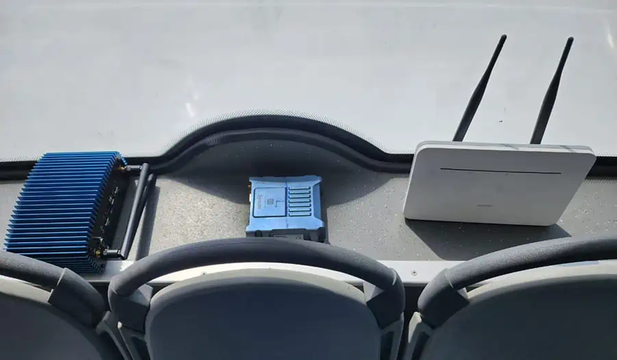
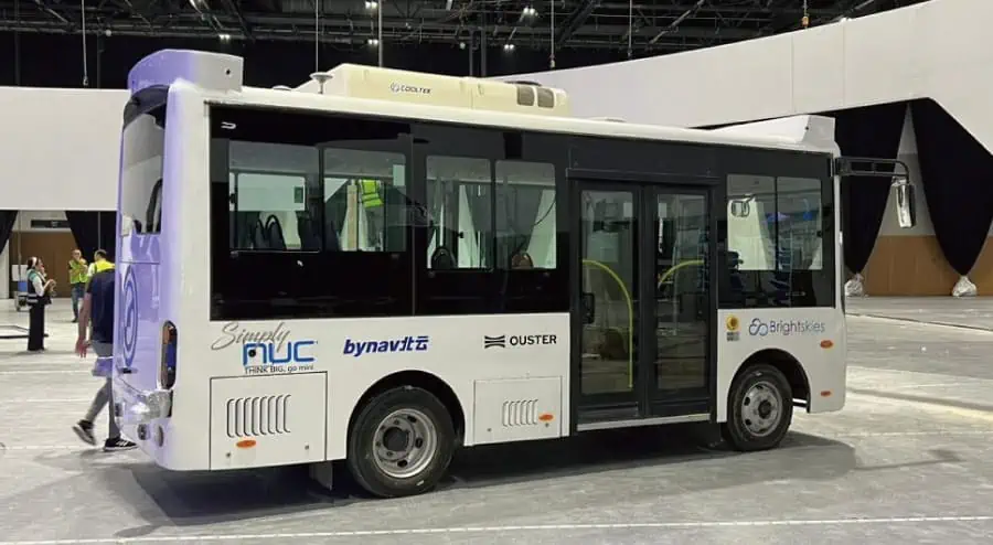
The Dubai Autonomous Driving Competition is known for its rigorous selection process, and recently Brightdrive, a Bynav Technology customer, has won second place in the third Dubai Autonomous Driving Competition, meeting these challenges with exceptional expertise.

One of the keys to BrightDrive’s success is the ability to overcome a range of challenging test cases. The self-driving bus demonstrated its precision and flexibility by flawlessly maneuvering through narrow passages. It demonstrates unparalleled perception, even in the harshest weather conditions such as sandy environments, effortlessly stopping at traffic lights and letting pedestrians pass, in which bynav X1 played a key role.

The cooperation between Bynav and Brightskies started in 2020, and the X1 has been widely and perfectly used in Brightskies powerful autonomous systems ever since.

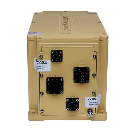
Bynav X1 is specifically developed based on the land vehicle INS model to tackle various complex urban enviroments. It incorporates deep-coupled algorithms, providing high Dead Reckoning (DR) accuracy with wheel speed fusion, along with automotive-grade hardware quality.

X1 offers high-precision and low-latency PVA data for applications such as:

  • Autonomous driving
  • ADAS (Advanced Driver Assistance Systems)
  • Mobile mapping

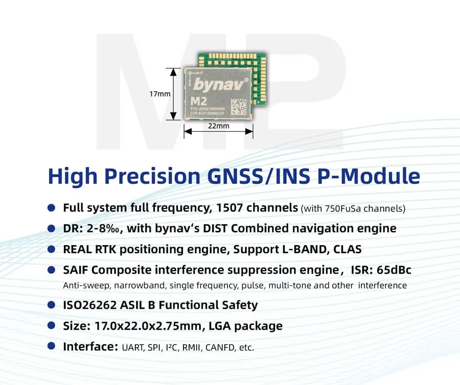
Bynav also offers low SWaP(size, weight and power) GNSS module M20 and GNSS/INS module M21/M22, which is coupled with a high-performance automotive-grade GNSS SoC and a fully temperature-calibrated precision IMU for enhanced positioning accuracy even in GNSS-denied environments such as urban canyons and satellite outages.

With triple-band L1/L2/L5 and strong anti-jamming ability, the M2 module delivers high reliability and cost-effectiveness for automotive OEMs and can be seamlessly integrated into the domain controller or intelligent driving systems of Tier 1 customers.

Bynav focuses on developing high-precision positioning GNSS chips, GNSS/INS modules and boxes. These products have been mass applied in numerous projects worldwide such as the L4 robotaxi, autonomous buses, port automation AGVs, autonomous mining machines, and more.

Posted by Sarah Simpson Specialising in digital copy Sarah is an experienced copywriter and researcher. Working with Unmanned Systems Technology Sarah has developed a passion for sourcing unique digital content and a talent for writing about the latest technical innovations in the unmanned sector. Connect & Contact

Latest Articles

Most Read Articles on UST This Week

Here’s our round-up of the five most read articles on UnmannedSystemsTechnology.com this week

Jul 11, 2025
Vertiq Speed Firmware v0.1.1 Now Available with Bug Fixes

Vertiq has released firmware v0.1.1 to correct a parameter bug affecting telemetry and 3D mode settings on select G1 and G2 modules

Jul 11, 2025
The Role of ROVs in Unmanned Marine Operations

Oceanbotics has answered the most common questions about ROVs, covering how they work, where they're used, and key capabilities

Jul 11, 2025
LiveU File Transfer Speeds Up Drone Data Delivery for Critical Missions

LiveU’s File Transfer enables rapid transmission of large drone data files, reducing delays and supporting faster decision-making in public safety and infrastructure operations.

Jul 11, 2025
Exploring Differences Between M9PLUS & M9 GNSS Antennas

Discover the key upgrades in Maxtena’s new M9PLUS GNSS antenna, including improved performance, signal purity, and multipath mitigation over the original M9

Jul 11, 2025
USAF Uses Inertial Labs Drone Lidar for Tree Obstruction Survey

The US Air Force successfully used Inertial Labs drone Lidar and cloud software to quickly map tree obstructions at Joint Base Lewis-McChord (JBLM), improving airfield safety

Jul 11, 2025

Featured Content

USAF Uses Inertial Labs Drone Lidar for Tree Obstruction Survey

The US Air Force successfully used Inertial Labs drone Lidar and cloud software to quickly map tree obstructions at Joint Base Lewis-McChord (JBLM), improving airfield safety

Jul 11, 2025
New UAV to Combine Solar Hydrogen & Battery Power for Extended Flight

XSun and H3 Dynamics are developing the first UAV powered by solar, hydrogen, and batteries, aiming to deliver zero-emission, long-endurance unmanned flight

Jul 07, 2025
Enhancing Mangrove Restoration Through 3D Printed Drone Design

Explore how Inverto Earth, in collaboration with HP Additive, is using sustainable 3D printing and drone technology to drive large-scale mangrove restoration and protect vulnerable coastal ecosystems

Jul 03, 2025
Advancing Unmanned Systems Through Strategic Collaboration UST works with major OEMs to foster collaboration and increase engagement with SMEs, to accelerate innovation and drive unmanned systems capabilities forward.