GeoCue Demonstrates New TrueView 680

GeoCue’s LiDAR and 3D Imaging Payload can be securely locked into position on a small SUV and ready for mobile mapping duty within 15 minutes By Abi Wylie / 11 Sep 2023
GeoCue Demonstrates New TrueView 680
Follow UST

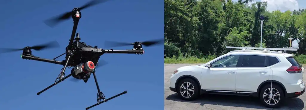
At The Commercial UAV Expo, GeoCue demonstrated the capabilities of its new TrueView 680 LiDAR and 3D Imaging Payload.

As part of this mobile mapping integration, the mobile mounting kit provides an enclosed system that protects the sensor from dust and debris. 

The system can also be configured with an optional Ladybug 360-degree camera and a Distant Measurement Instrument (DMI-wheel specific) that helps keep the trajectory accurate when GNSS is disturbed.

In addition to the TrueView 680, an optional upgrade is also available for the TrueView 655/660 and the TrueView 535 to enable dual purpose aerial and mobile mapping LiDAR.

Vivien Heriard Dubreuil, CEO of mdGroup (parent company of GeoCue), recounts a demonstration: “The new TrueView 680 LiDAR and 3D Imaging Payload attached to a heavy payload drone, touched down in the testing area collecting aerial data of the GeoCue headquarters. 

“A drone pilot approaches the system, quickly removes the sensor from its quick release, and hands it off to a colleague. Within 15 minutes the TrueView 680 was securely locked into position on the small SUV and ready for mobile mapping duty.”

According to CEO of GeoCue Frank Darmayan, “Customers were telling us that they wanted to purchase one LiDAR system that could also work for both aerial and mobile ground projects. They wanted easy to use software to process and visualize data.”

Darmayan added, “Whether a project requires an aerial perspective, a ground mobile perspective, or both, the TrueView 680 and 680LR provide the complete package. Both systems integrate Riegl LiDAR technology, with a field of view up to 360° for practically unrestricted data acquisition. By land or air, these systems provide unparalleled accuracy and precision.”

Heriard-Dubreuil explained, “We are continuously aligning our products with customer needs. In addition to this newly released mobile mapping capability we are also pleased to announce the release of the new TrueView 625. This system is based on the Riegl mini-VUX 1, and similar to our TrueView 655/660 it includes triple cameras… all this while hitting a sweet spot on price and performance. It’s already getting quite a bit of attention from our customers, who say it fills an important niche. Best of all, all TrueView 600-series payloads are NDAA-compliant.”

Vincent Legrand, VP of Sales, said, “We offer turnkey solutions for our customers and dealers. Our expertise in hardware integration, software, workflow, training, and support from one company is a unique advantage that we can offer, and we’re excited about the growth that comes with that.”

Find Drone LiDAR manufacturers and suppliers of airborne LiDAR systems for UAV, UAS and Unmanned Helicopters >>

Posted by Abi Wylie Connect & Contact

Latest Articles

Nationwide UTM Network to be Implemented in Norway

Thales has partnered with Avinor to deploy a safe and scalable digital platform for automated UTM as well as future AAM operations

Jan 13, 2025
Multi-Use BVLOS Drone Dock Network Launched

A2Z Drone Delivery’s new multi-use drone dock network achieves BVLOS with a single operator managing multiple drones, marking the company’s first drone service deployment

Jan 13, 2025
Combining Batteries & Fuel Cell Technology to Enhance Long-Range UAS Operations

Edge Autonomy is enhancing UAS capabilities by combining advanced batteries with its innovative MT-SOFC fuel cell technology, offering endurance, stealth, and operational flexibility for evolving mission demands

Jan 13, 2025
Protecting Drone Electronics with SCS PrecisionCoat VI Underfill & Potting

Specialty Coating Systems (SCS) outlines the capabilities of its PrecisionCoat VI system, designed to automate underfill and potting material applications, enhancing production efficiency and ensuring precision in drone electronics manufacturing

Jan 13, 2025
Effective and Reliable Jam-Resistant GPS: Meteksan’s AGNOSIS GNSS

Explore Meteksan Defence's advanced GNSS anti-jamming and anti-spoofing solutions, including their AGNOSIS system, designed to protect military platforms from signal interference in modern warfare

Jan 13, 2025
Understanding GNSS Correction Methods

CHCNAV delves into the main GNSS correction techniques, their characteristics, and applications to help make informed choices for specific requirements

Jan 13, 2025

Featured Content

New Safety System Unveiled for Anzu Raptor Drones

ParaZero has launched the SafeAir Raptor, a parachute safety system for Anzu Robotics’ Raptor and Raptor T drone models that complies with ASTM F3322-22 standards

Jan 08, 2025
How ANELLO’s Disruptive SiPhOG™ Technology is Shaping the Future of Precision Navigation

UST sits down with Dr. Mario Paniccia, CEO at ANELLO Photonics, to learn how Silicon Photonics Optical Gyroscope technology is empowering autonomous systems with cutting-edge navigation solutions

Jan 06, 2025
XPONENTIAL Europe Highlights Autonomous Robotics for Perimeter Security

XPONENTIAL Europe, held in Düsseldorf from 18-20 February 2025, will focus on uncrewed systems and highlight their use for protecting critical infrastructure

Jan 02, 2025
Software-Defined Networking Capability Selected for Attritable Autonomous Systems

Viasat will provide its NetAgility SDN system in support of the US DoD's Replicator initiative

Dec 24, 2024
Assured PNT Solution Released for RF Protection

The new GAJT-310 from NovAtel is the company’s latest battle-proven low SWaP GNSS Anti-Jam Technology, designed for unmanned systems on land, in the air, or at sea

Dec 20, 2024
New AI-Powered Drone-in-a-Box Solution for First Responders & Mission-Critical Industries

The solution integrates Nokia Drone Networks with Motorola Solutions’ CAPE drone software for navigation and obstacle avoidance

Dec 16, 2024