50-Megapixel Camera Integrated into ScanEagle UAV

By Mike Ball / 20 Jun 2017

Smart Sourcing for Unmanned Systems

Discover cutting-edge solutions from leading global suppliers
SUPPLIER SPOTLIGHT
Follow UST

Insitu UAV Camera

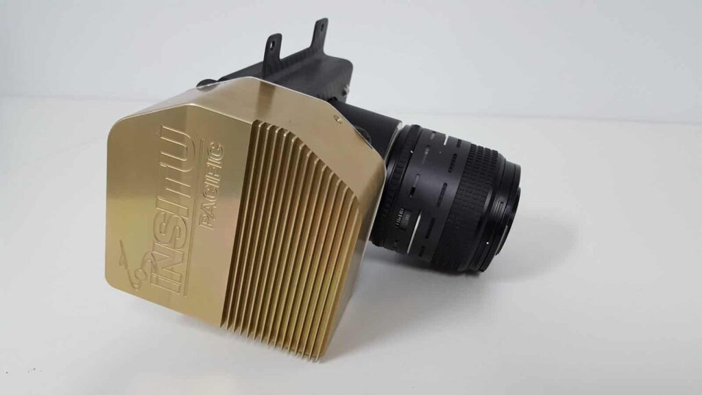
Insitu has announced the successful integration of a 50-megapixel camera into its ScanEagle Unmanned Aerial Vehicle (UAV) for delivering High Accuracy Photogrammetric (HAP) aerial imagery. This new capability is part of Insitu’s INEXA Solutions, a comprehensive suite of remote sensing products and information delivery services for enterprise customers, particularly mining and oil and gas operations.

The HAP-equipped ScanEagle remotely surveys broad areas quickly, accurately, and safely — due to ScanEagle’s proven Beyond Visual Line of Sight performance and Insitu’s specialized direct georeferencing system, combined with the accuracy of the carefully selected, purpose-built 50-megapixel aerial camera.

Currently, to produce georeferenced data, mining and onshore oil and gas enterprises monitor broad areas using Geographic Information Systems (GIS), adding thematic layers into their analytical environments to make informed business decisions. To address that need, Insitu uses aerial remote sensing to collect, analyze, and deliver critical information to mine and extraction asset operators while avoiding any disruption in operations.

Compared to current photogrammetric payloads, Insitu’s HAP payload dramatically decreases the aerial survey flight and processing time — allowing precise broad area survey, and the delivery of a georeferenced site Digital Surface Model (DSM). Insitu’s HAP payload achieves this quick turnaround by taking many high resolution images and integrating them to make a broad-area view. This process produces fast, accurate orthomosaics, enabling the delivery of concise volumetric and stockpile measurements. The end goal is to deliver precise business knowledge to customers rapidly, enabling superior decision-making for business optimization, cost reduction, and enhanced safety.

“Insitu’s INEXA Solutions suite of products and services can be considered a ‘modular toolbox,’ with state-of-the-art remote sensing products and services,” said Jon Damush, Vice President and General Manager, Insitu Commercial. “We are dedicated to developing revolutionary capabilities going forward, by leveraging Insitu’s technology experience and The Boeing Company’s 100 years of aviation innovation.”

Find suppliers of Cameras for UAS >

Posted by Mike Ball Mike Ball is our resident technical editor here at Unmanned Systems Technology. Combining his passion for teaching, advanced engineering and all things unmanned, Mike keeps a watchful eye over everything related to the unmanned technical sector. With over 10 years’ experience in the unmanned field and a degree in engineering, Mike’s been heading up our technical team here for the last 8 years. Connect & Contact

Latest Articles

Precision RTK GNSS Positioning for UAVs & Unmanned Systems

RTKdata provides access to a world-leading RTK corrections data network with over 12,000 base stations in more than 140 countries

Mar 27, 2025
WOLF Introduces New VPX Modules with High-Performance Blackwell GPUs

WOLF Advanced Technology has unveiled new 3U and 6U VPX modules featuring NVIDIA Blackwell GPUs, offering high-performance AI computing for rugged systems

Mar 27, 2025
Volatus Expands Medical Delivery Network with Long-Range Drone

Volatus Aerospace is expanding its medical delivery network by integrating RigiTech’s Eiger long-range delivery drone, allowing for extended reach across Canada and underserved regions

Mar 27, 2025
Ruggedizing Products Built for Extreme Conditions with Conformal Coatings

Specialty Coating Systems discusses Parylene conformal coatings and how they can advance the ruggedization of products in environmentally challenging settings

Mar 27, 2025
Enhancing EO/IR Imaging Performance with Velox

Velox outlines the advantages of its compact EO/IR imaging system that delivers stabilized, high-resolution performance for defense, security, and industrial surveillance applications

Mar 27, 2025
Submersible Captures First Sighting of Prickly Shark in French Polynesia

SubC Imaging's latest case study outlines how its 1Cam Mk6 deep-sea camera, mounted on the SEAmagine Aurora submersible, captured a sighting of a prickly shark in French Polynesia

Mar 27, 2025

Featured Content

Be Part of the World’s Largest Business Accelerator for Uncrewed Systems: Applications Now Open

GENIUS NY, a drone and robotics accelerator program, is now accepting applications from tech startups focused on uncrewed aerial systems, to automation and Advanced Air Mobility (AAM)

Mar 25, 2025
How IONA Reaches the Last Mile Through Smart Product Development

In this webinar, learn from Drone Industry Insights about scaling production and supply chain challenges, strategies from Arena by PTC to optimize product development, and how IONA Drones are advancing last-mile delivery

Mar 18, 2025
Nokia Talks to UST about 4G/5G Connected Drone-in-a-Box Advancements

How Nokia is revolutionizing drone connectivity with 4G and 5G, and advancing autonomous operations with the cutting-edge drone-in-a-box solution; Nokia Drone Networks

Mar 16, 2025
Advancing Unmanned Systems Through Strategic Collaboration UST works with major OEMs to foster collaboration and increase engagement with SMEs, to accelerate innovation and drive unmanned systems capabilities forward.