


Discover World-Leading Unmanned and Autonomous Technologies
Discover cutting-edge solutions from leading global suppliers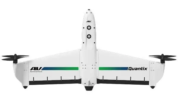
AeroVironment has announced the launch of its new integrated commercial information solution featuring the new Quantix drone and Decision Support System (DSS). These technologies allow users to gain actionable insights that can improve operational efficiencies, minimize risk and increase profitability.
Quantix features simple, automated flight with an operator-in-the-loop, and a unique hybrid design that allows the aircraft to launch vertically and transition into horizontal flight, maximizing aerodynamic efficiency and range.
Find suppliers of Unmanned Aerial Vehicle platforms >
To plan a mission, the operator simply traces their finger over a map displayed on the tablet controller screen to identify an area of interest. The system guides the operator through a simple, automated pre-flight check to ensure a safe, reliable mission. The operator then presses the “fly” button and Quantix does the rest, including performing a detailed built-in test procedure, optimizing its flight path for maximum coverage, launching, and then landing vertically when its mission is complete after scanning hundreds of acres with its color and multispectral sensors. Quantix is designed to be the first practical commercial drone combining the advantages of vertical liftoff, for safe launch and soft landing, and horizontal flight to acquire data quickly and easily. It also includes “land now” and “return home” command safety features for complete control.
At the heart of AeroVironment’s Commercial Information Solutions business is the Decision Support System. AeroVironment’s DSS uses advanced research and algorithms to produce high-resolution datasets and analysis of agriculture fields and vineyards, bridges, railroad tracks, pipelines, roads and many other valuable assets. It has easy-to-use mobile interfaces with secure cloud-based data storage. Developed with proprietary algorithms, the AV DSS is the foundation for powerful data processing, integrating data streams from multiple types of sensors and data collection tools and capable of securely storing large amounts of image data for historical trend analysis.
“AeroVironment’s Commercial Information Solutions business integrates remote sensing and surveying with cloud-based data analytics to help customers in multiple industries increase the efficiency of their operations,” said Wahid Nawabi, AeroVironment chief executive and president. “Quantix and AV DSS provide our customers the first truly one-stop, full-service decision-support-system so they can make smarter, quicker decisions that will help increase their revenue and reduce uncertainty and risk.”
Nawabi added, “Our customers told us they want to focus on running their businesses, not on becoming drone experts. That’s why we designed our highly automated system from the ground up to make it easy for them to get the insights they need so they can proceed with certainty. From an easy-to-use and reliable drone, to easy-to-access analytics, customers will benefit from our industry-leading drone and sensor technologies, proven reliable by the most exacting customers in the harshest environments on the planet.”


