Trimble Adds UX5 Unmanned Aircraft System to its Agriculture Portfolio

By Caroline Rees / 21 Jan 2014

Smart Sourcing for Unmanned Systems

Discover cutting-edge solutions from leading global suppliers
SUPPLIER SPOTLIGHT
Follow UST

Trimble UX5 UAS  for Agriculture

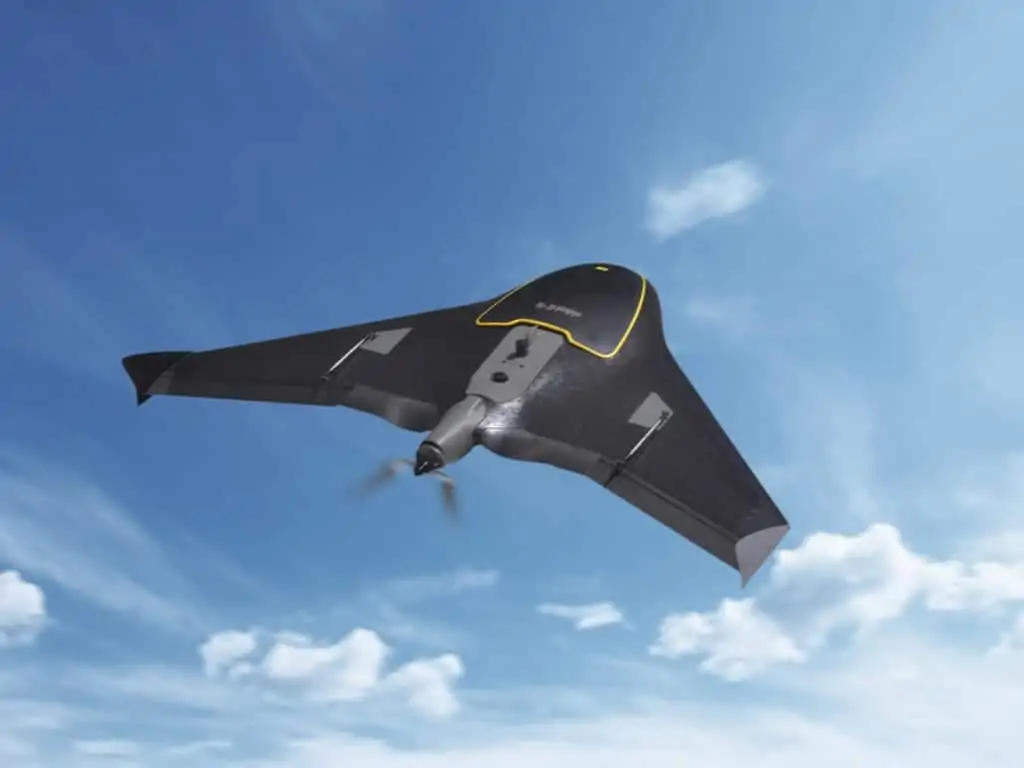
Trimble has announced the addition of its TrimbleĀ® UX5 unmanned aircraft system (UAS) to its Agriculture product portfolio for aerial imaging and mapping. The Trimble UX5 system can enable Ag service providers to easily capture aerial images for scouting and monitoring crop health such as detecting pests, weeds and nitrogen deficiencies. The system can locate cattle and their available forage over large areas, measure crop height, and generate topographic maps and models for land leveling and drainage applications. As a result, the system provides farmers’ trusted advisorsā€”such as agronomists, Trimble resellers, and other Ag service providersā€”with a powerful data collection tool that can aid with recommendations to improve farming operations.

The Trimble UX5 system flies at 80 kilometers/hour (50 mph) and is stable in significant crosswinds and even light rain. In a single 50-minute flight, the Trimble UX5 system can cover a two square kilometer (0.8 square mile) area at five centimeter (two inch) image resolution. It comes with a camera modified to capture the near-infrared spectrum, which helps in deducing vegetation indexes for crop health assessment. The Trimble UX5 system can capture a variety of images to be processed post flight. The output of a single flight provides geo-referenced precision images, a digital surface model (DSM) showing elevations as a color image, and a dense 3D point cloud that includes elevations.

“The addition of the Trimble UX5 system strengthens our agriculture product portfolio and enables us to provide a solution that benefits a broad range of customers including growers, ranchers, water management contractors, agronomists and other Ag service providers,” said Joe Denniston, vice president of Trimble’s Agriculture Division. “High-speed aerial imaging is a powerful tool that can quickly and easily locate problem areas to be addressed. The faster a problem area is discovered, the better the chance it can be evaluated and resolved before crop yield is impacted.”

Trimble provides training for system operators and their observers, which focuses on safety precautions and the application of the Trimble UX5 system for maximum success. The Trimble UX5 system is available from Authorized Agriculture Distribution Partners and is subject to regulations and restrictions defined by local civil aviation authorities.

Posted by Caroline Rees Caroline co-founded Unmanned Systems Technology and has been at the forefront of the business ever since. With a Masters Degree in marketing Caroline has her finger on the pulse of all things unmanned and is committed to showcasing the very latest in unmanned technical innovation. Connect & Contact

Latest Articles

Loitering Munitions to be Integrated with Trillium Drone Camera Gimbals

Trillium Engineering has secured a Phase One contract with Raytheon to supply its HD25-LV drone camera gimbal for loitering munitions, supporting operations with tactical EO/IR solutions

Feb 18, 2025
Enhancing USV Navigation with 3D Forward Looking Sonar Technology

FarSounderā€™s Argos series 3D Forward Looking Sonars enhance USV navigation by providing real-time underwater awareness, overcoming charting limitations, and improving safety across diverse maritime applications

Feb 18, 2025
Hydrogen Fuel-Cell Powered VTOL UAV Introduced

BlueBird Aero Systems introduces the WanderB-VTOL Mini-UAS, built for rapid deployment in any environment and powered by new PEW Fuel-Cell Technology

Feb 18, 2025
Product Spotlight: XPedite7770 High-Performance Single Board Computer

The XPedite7770 from Extreme Engineering Solutions delivers secure, high-performance computing for unmanned systems, featuring IntelĀ® XeonĀ® D-1700 processors, advanced networking, and SOSA-aligned architecture

Feb 18, 2025
European Drone Battery Maker Opens U.S. Operations

Tulip Tech, a European drone battery manufacturer, is expanding into the U.S. to meet rising demand, offering advanced, high-performance power solutions for drones

Feb 18, 2025
How to Use NTRIP RTK with ArduSimple Receivers

In this tutorial, learn how to use ArduSimple's simpleRTK receivers with Mission Planner and QGroundControl to send NTRIP RTK corrections to your autopilot for improved accuracy

Feb 18, 2025

Featured Content

Military Vehicles to Feature Small Tethered UAS from Elistair

Elistair has secured a ā‚¬3 million contract to equip military vehicles with tethered UAS, enhancing real-time intelligence and operational awareness

Feb 13, 2025
Ellipse Series Enhanced with Latest Firmware Upgrade

The new firmware update from SBG Systems integrates the latest World Magnetic Model (WMM) to improve navigation precision, even for first-generation Ellipse sensors

Feb 11, 2025
Advanced FOG-Based Inertial Sensing Solutions for Drones & Robotics

Aegiverse's products feature a multi-layered architecture that combines multiple elements into a compact module, providing significant, size, weight and cost reductions

Feb 06, 2025