


Discover World-Leading Unmanned and Autonomous Technologies
Discover cutting-edge solutions from leading global suppliers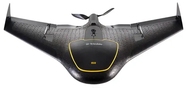
Trimble has introduced its next generation Unmanned Aircraft System (UAS) – the Trimble® UX5 aerial imaging rover with the Trimble Access™ aerial imaging application.
The new solution builds upon the strengths of its predecessor, the Trimble Gatewing X100, to offer enhanced image quality and intuitive workflows. Combined with the Trimble Business Center photogrammetry office software module, the Trimble UX5 is the first complete UAS photogrammetric mapping solution specifically designed for surveyors and geospatial professionals.
Trimble’s UAS for photogrammetric aerial mapping allows surveyors and geospatial professionals to collect data with an unmanned aircraft for large projects. A wide variety of traditional surveying applications such as topographic surveying, site & route planning, progress monitoring, volume calculations, disaster analysis and as-builts in industries such as surveying, oil & gas, mining, environmental services, and agriculture can now benefit from aerial imaging by allowing professionals to safely collect large amounts of accurate data in a short time.
“With the recent introduction of the Trimble Business Center photogrammetry module and now the Trimble UX5 and Trimble Access aerial imaging application, Trimble continues to pioneer the development of UAS photogrammetry data collection and integration for geospatial professionals,” said Erik Arvesen, vice president of Trimble’s Survey Division. “The complete solution represents a significant leap in efficiency, transforming traditional workflows with faster data collection, easier processing and enhanced deliverables.”
Intuitive Workflows and Automated Procedures
The new Trimble Access aerial imaging application is field software for planning UAS missions, performing flight checks and monitoring flights—all with intuitive workflows.
The imaging application is used to define the project area, avoidance zones, and flight parameters as well as take-off and landing locations. In the field, it is used to perform pre- and post-flight checks and download the flight data and images after landing. The new wizard-like digital checklists give the operator a complete “to do list” so critical steps are not bypassed or missed in the field that can enhance reliable and safe flights. The software also includes fixed post-flight procedures to ensure that operators do not leave the field with a dataset that is incomplete or inconsistent.
The Trimble UX5 can provide a safer method to collect data compared to traditional surveying methods. Flights are fully automated, from launch to landing, and require no piloting skills. The operator facilitates the aircraft’s operation and built-in safety procedures can ensure safe and successful launches. Data collection can be performed remotely without exposing individuals to hazardous terrain, environmental contaminants or heavy equipment and machinery.
Enhanced Imagery
The Trimble UX5 aerial imaging rover has been designed to follow the latest developments in the ‘prosumer’ camera market, providing optimal image quality along with maximum photogrammetric accuracy.
Incorporating a mirrorless 16-megapixel camera with a fixed focal-length external lens, the Trimble UX5 provides high-resolution imagery and accurate deliverables. The large field of view from the camera allows the UX5 to cover 50-75 percent more area to enhance efficiency and reduce operational costs. In addition to the increase in flight efficiency, the Trimble UX5 is capable of producing 3D surface deliverables with a ground sampling distance of approximately 2.4 centimeters (approximately 1.0 inch).
Durability and Performance
Designed to operate in real-world conditions, the Trimble UX5 is capable of flights between 75 and 750 meters (approximately 246 and 2,460 feet) above ground level and can be flown in light rain and windy conditions, up to 65 kph (approximately 40 mph).
The Trimble UX5 airframe is comprised of a carbon frame inside expanded polypropylene. Impact-resistant plastics and composite fibers are used for the aircraft components, including winglets and belly plate. This design and choice of materials results in a rigid aircraft with strong torsional stability and the ability to withstand rough landings.
Performance enhancements also include the ability to execute steep landing approaches and thrust reversal for accurate and repeatable landings. The landing procedure starts only 300 meters (approximately 984 feet) from the landing location allowing the UX5 to be used for jobs that have site restrictions such as buildings, towers or trees.
Powerful Deliverables
Orthophotos, contour maps, point clouds, digital surface models (DSMs) and feature maps can easily be created from aerial images using the Trimble Business Center photogrammetry module. Single-click processing for stitching images streamlines the office process for generating powerful deliverables.
In addition to producing these powerful photogrammetric deliverables, Trimble Business Center allows surveyors and other geospatial professionals to combine aerial photography with data collected from GNSS receivers, total stations, 3D laser scanners and more, for a one-of-a-kind integrated solution. By easily combining imagery from the Trimble UX5 and any Trimble VISION™ instruments, users can visualize their project from both aerial and terrestrial perspectives, measure points within the images and create 3D models of the infrastructure and terrain.
Availability
The new Trimble UX5 aerial imaging solution, including the Trimble Access aerial imaging application, is available now through Trimble’s Survey Distribution Channel in markets where UAS commercial operations are permitted. The Trimble Business Center photogrammetry module is available now.


