


Fixed-Wing Mapping Drones
Discover cutting-edge solutions from 4 leading global suppliers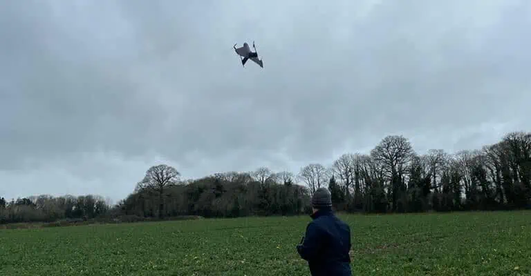
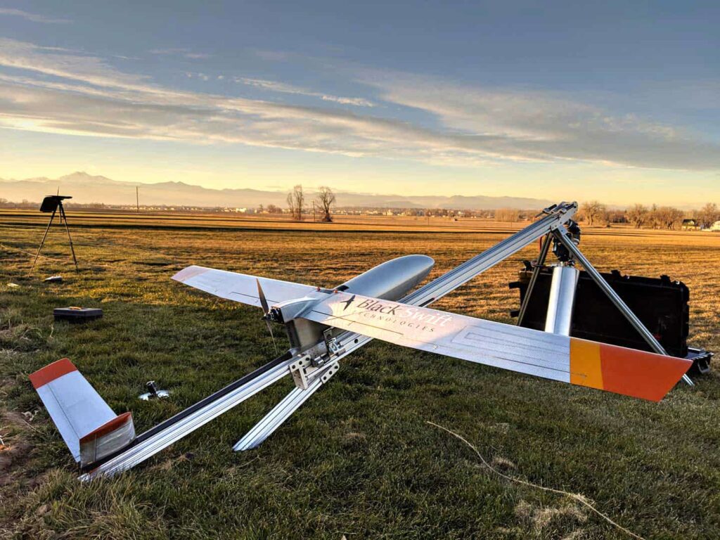
Atmos has released a case study that explains how Neptune Site Services used the company’s Marlyn Cobalt drone equipped with the MicaSense Altum sensor to develop a correlation between Green Area and Normalized Difference Vegetation indices for a canola field in Ireland.
Nitrogen Fertilizer is an essential tool in most agricultural and farming applications, but this comes at a cost, with Nitrogen prices surging recently from €250/ton to €750/ton (2021 to 2022) due to increased gas prices. Therefore, in order for crops to be viable, growers need an exact picture of where and how much Nitrogen is needed for their crops to grow to the optimal extent. With thin margins all across the industry, the need to maximize overall yield has never been greater.
When it comes to Oilseed Rape, growers around the world carry out random spot checks of GAI (Growth/Green Area Index) to calculate when and where Nitrogen application is required. The GAI is defined as the ratio between the leaf area and the ground area (various examples of GAI values are shown below).

Green/Growth Area Index (GAI)
This can be a very effective metric, however, spot checks only allow growers to sample very small areas of their crop and the result is not a true picture of the complete situation. One way around this is to use satellite imagery, but this can be unreliable due to the low resolution, and relative inaccessibility because of cloud cover and other climactic conditions such as atmospheric pressure. Therefore, a solution is needed which provides a reliable GAI across the entire crop, without sacrificing accuracy.
To solve this, Brian Whyte from Neptune Drone Services (Ireland), and the project’s agronomist, Stephen McCabe, used a Marlyn Cobalt equipped with the MicaSense Altum to develop a correlation between the GAI index and the NDVI (Normalized Difference Vegetation Index), produced from the Altum’s multispectral sensors. This was then used to create an accurate, georeferenced variable rate Nitrogen map of the entire crop which can then be then uploaded to the spreader or sprayer for correct application.
Drone survey with Marlyn Cobalt
After surveying 47.1 hectares of Oilseed Rape (canola) in 26 minutes, Brian Whyte from Neptune was able to produce an accurate zonation map with the geotagged data collected by Marlyn. This zonation map was then used to form a variable rate map for Nitrogen use that will be loaded to the tractor.
Neptune Drone Services (Ireland)
Below you can see the georeferenced zonation map which was produced from this project.
The yellow part of this map indicates the areas where GAI is higher, and the orange and red spots indicate the areas with lower GAI values where more Nitrogen is needed. In this example we see a relatively high average GAI because of the mild winter. Each zone will then be assigned a required rate of Nitrogen and spread using a GPS-assisted variable rate fertilizer spreader, meaning that each zone gets only the required amount of Nitrogen.
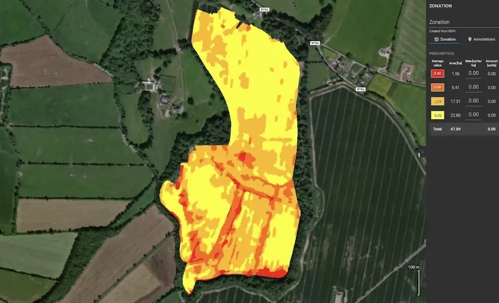
Zonation Map
Savings in Nitrogen costs (post-winter)
In the table below you can see savings in Nitrogen costs for the post-winter period for various crop sizes.
As shown in the table, the higher the GAI, the higher the potential cost saving. For example, a medium crop with GAI of 1.0 needs 202kg/ha of fertilizer saving €83/ha, while a very large crop with GAI of 2.0 needs 135kg/ha saving €250/ha.
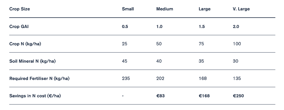
Fertilizer N Savings per Crop Size, Source: www.teagasc.ie
As a comparison and to validate the data, the grower and his agronomist then carried out a GAI assessment of the crops using the traditional method. Using the zonation map, they were able to focus on each zone and make a correlation between the GAI value and the average NDVI value to determine the required rate of Nitrogen. This correlation in values was successfully checked across multiple farms assessed on different days and under different lighting conditions to prove the consistency of the values and to demonstrate that the correlation between GAI and the average NDVI value was repeatable.
The next step is to carry out the next GAI assessment where the grower ideally wants to see the same value of GAI across the whole field. For this assessment, proving of GAI using the traditional method will no longer be required, as the correlation of the two index values was successful, thus proving that a variable rate Nitrogen map can be produced for Oilseed rape crops based on the average NDVI value.
Conclusion
Therefore, it can be decisively concluded that using NDVI/GAI comparison method is an effective way for farmers to reduce and optimize their Nitrogen fertilizer consumption, thus increasing yield and decreasing operational costs. In Ireland alone there is more than 10,000 ha of Oilseed Rape where this method could result in savings of more than €2 million.
The use of the Marlyn Cobalt drone produced an effective and accurate NDVI map across the entire field for use in this comparison, without sacrificing the resolution and flexibility as seen with satellite data collection methods. Further assessment needs to be done for the coming survey, but in the meantime it can be recommended to any crop farmer with a passion for innovation and a desire to take their activities to the next level to use the Marlyn Cobalt and Micasense Altum for their Oilseed Rape surveys.
“The accuracy of the Marlyn drone equipped with the MicaSense Altum sensor has made big impact on crop growers’ savings and yield,” said Brian Whyte, Neptune Site Services.


