Collaboration Offers Actionable Data to Public Safety Agencies & Drone First Responders

Skyfire Consulting has been working with Textron Systems to help shape its geospatial data analysis and image processing software and services for the public safety market By Caroline Rees / 15 Nov 2022

Public Safety Drones

Discover cutting-edge solutions from 13 leading global suppliers
SUPPLIER SPOTLIGHT
SeeGEO
Follow UST

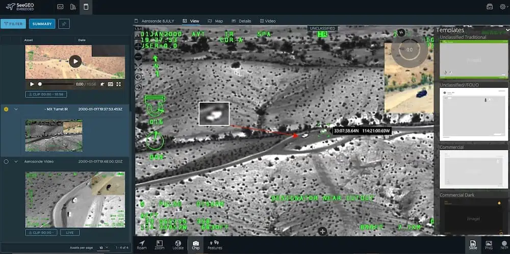
Skyfire Consulting has partnered with Textron Systems to offer more actionable data to public safety agencies and Drone First Responder (DFR) programs. 

The companies have been working closely to help shape Textron Systems’ geospatial data analysis and image processing software and services for the public safety market. 

“As an industry, we’ve done very well getting first responders quality aircraft to fly and getting that data back to the ground in real-time,” said Matt Sloane, Skyfire founder and CEO. “Teaming up with Textron Systems takes that to the next level and allows agencies the ability to make sense of all of the data they collect and use it to help make better decisions in protecting the public.”

“Textron Systems is bringing over 25 years of experience supporting thousands of geospatial customers across the world as trusted providers of high performance, analytical software,” said Steve Mensh, Senior Vice President of Electronic Systems. “Guided by Skyfire’s vast experience working in the first responder community, we’ve worked together as a team to deliver easy to use, workflow-based solutions.”

Skyfire is an official reseller of Textron Systems’ SeeGEO software, which allows first responders to create detailed mapping products from drone video footage, take accurate measurements, apply artificial intelligence and machine learning algorithms to their data and create intelligence products that will allow them to make informed decisions about the collected data.

Posted by Caroline Rees Caroline co-founded Unmanned Systems Technology and has been at the forefront of the business ever since. With a Masters Degree in marketing Caroline has her finger on the pulse of all things unmanned and is committed to showcasing the very latest in unmanned technical innovation. Connect & Contact

Latest Articles

Cellen Expands UAV Mission Capabilities with Hydrogen Fuel Cell Technology

Cellen outlines how its H2‑6 hydrogen-powered drone delivers long-endurance flight and zero-emission performance, overcoming battery limitations and enabling reliable, low-impact operations in sensitive or remote environments

Jul 15, 2025
Tulip Tech Extends Autonomous Drone Missions with Lithium Metal Technology

Tulip Tech and Tective have partnered to extend the ReFly drone’s range and endurance using advanced Lithium Metal battery technology

Jul 15, 2025
UAV Navigation to Supply Flight Control System for Fixed-Wing UAV Platform

UAV Navigation collaborates with SE Aviation to provide the DRIADE UAV with a VECTOR-600 flight control system enabling autonomous reconnaissance and wildfire response missions

Jul 15, 2025
AlarisPro Empowers UAS Operators to Meet Federal Mandates with Safety & Compliance Tools

AlarisPro describes how their Fleet Management Platform is positioned to help UAS operators prepare for BVLOS certifications under the new Executive Order

Jul 15, 2025
Police Department Utilizes Drones to Map Crash & Crime Scenes

Discover how Windham Police use drones and Blue Marble Geographics’ GIS tools to enhance crash investigations, speed up processing, and improve scene accuracy

Jul 15, 2025
SPECTRUM300 Mission-Ready Imaging for Small UAV Platforms

Explore Blitz Technology SPECTRUM300, a 330g dual-sensor gimbal delivering full HD EO and thermal imaging, built for lightweight UAVs and demanding ISR missions

Jul 15, 2025

Featured Content

SBG Systems Evaluates INS Performance in GNSS-Denied Marine Applications

SBG Systems evaluates the performance of its INS solutions in GNSS-denied marine environments, comparing system accuracy with and without DVL and warm-up support

Jul 14, 2025
USAF Uses Inertial Labs Drone Lidar for Tree Obstruction Survey

The US Air Force successfully used Inertial Labs drone Lidar and cloud software to quickly map tree obstructions at Joint Base Lewis-McChord (JBLM), improving airfield safety

Jul 11, 2025
New UAV to Combine Solar Hydrogen & Battery Power for Extended Flight

XSun and H3 Dynamics are developing the first UAV powered by solar, hydrogen, and batteries, aiming to deliver zero-emission, long-endurance unmanned flight

Jul 07, 2025
Advancing Unmanned Systems Through Strategic Collaboration UST works with major OEMs to foster collaboration and increase engagement with SMEs, to accelerate innovation and drive unmanned systems capabilities forward.