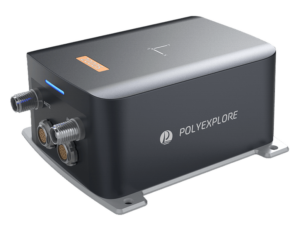
 PolyExplore has launched the Polynav 2000S, an RTK GNSS-aided INS (Inertial Navigation System) that provides near-FOG performance in a MEMS package. The system offers dual antennas for precision heading, and dual-frequency RTK support for centimeter-level accuracy with fast conversion times. The Polynav 2000S is ideal for a wide range of unmanned systems applications, such as UAVs (unmanned aerial vehicles) and UGVs (unmanned ground vehicles).
With tightly-coupled GNSS and INS systems, the Polynav 2000S maintains excellent performance during GNSS signal outages. It supports fusion of odometer inputs for autonomous ground vehicle urban navigation and mapping, as well as heave estimation for marine applications. The system is available as an OEM version, or enclosed in a rugged IP67-rated housing with overall dimensions of 166mm x 134mm x 70mm and a weight of approximately 800 g.
The Polynav 2000S INS/GNSS features a high-performance tactical-grade MEMS inertial measurement unit (IMU) that provides heading accuracy of 0.08° at 1 m baseline, as well as roll and pitch (RTK) of 0.015°. The dead reckoning feature of the Polynav 2000S provides low drift of less than 2m in 30 seconds during GNSS outages.
The Polynav 2000S is a member of the Polynav 2000 family of GNSS-aided INS, which offers a choice of MEMS of FOG tactical grade IMUs for various performance and budgetary requirements. All models feature dual-frequency RTK, dual antennas, heave measurement for Marine applications, Distance Measurement Instrument (DMI)-assisted dead reckoning for urban canyons, as well as an interface for LiDAR/Radar synchronization and camera triggering for HD mapping applications.


