Spirent Develops GPS/GNSS Simulation and Test Solutions for Unmanned Systems

By Mike Ball / 06 Oct 2016

Smart Sourcing for Unmanned Systems

Discover cutting-edge solutions from leading global suppliers
SUPPLIER SPOTLIGHT
Follow UST

GSS7000 Multi-GNSS Constellation Simulator SystemSpirent, a developer of simulation and test solutions for GPS/GNSS satellite-based navigation and positioning in unmanned systems, has partnered with Unmanned Systems Technology (“UST”) to demonstrate their expertise in this field. The ‘Gold’ profile showcases how their test and simulation solutions can be used to overcome the challenges of developing autonomous unmanned vehicles, such as self-knowledge of position and attitude, safe and accurate navigation, and recovery from signal loss, as well as operation in harsh environments.

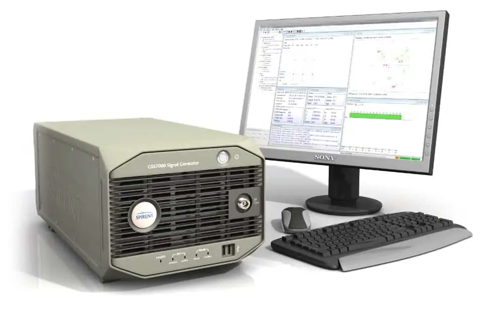
The GSS7000 Multi-GNSS Constellation Simulator is an entry-level test tool for verifying the positioning performance of unmanned vehicles under controlled, repeatable conditions. The accurate, powerful system allows simultaneous GNSS signals (supporting GPS, GLONASS, BeiDou, Galileo, QZSS and SBAS) across a wide range of frequencies, enabling test regimes that provides maximum rigour with minimum time and cost.

The GSS9000 GNSS Constellation Simulator is Spirent’s most advanced test solution, providing the sophisticated and accurate testing required for the precise positioning, navigation and timing systems of unmanned vehicles in military, aerospace and research applications. The GNSS9000 supports all signals and frequencies from all GNSS constellations, both present and under development, including regional augmentation systems and classified/restricted signals.

GSS6425 Multiple Constellation Record & Playback SystemThe GSS6300 GPS/GNSS Signal Generator is designed for fast, accurate testing of multiple GNSS signals in a volume production test environment. The GSS6300 applies controllable, repeatable test signals directly to the product under test, thus avoiding problems with the electrically noisy conditions of a production environment and providing greater end-of-production line quality control than usage of uncontrollable “live-sky” signals.

The GSS6425 Multiple Constellation Record & Playback System records real-world GNSS signals, allowing developers to cut down on test flights and re-use captured flight data in the lab. This avoids slow, non-repeatable testing with live signals, thus saving travel and engineering costs and resulting in consistent, cost-effective results.

To find out more about Spirent, please visit their profile page: https://www.unmannedsystemstechnology.com/company/spirent/

Posted by Mike Ball Mike Ball is our resident technical editor here at Unmanned Systems Technology. Combining his passion for teaching, advanced engineering and all things unmanned, Mike keeps a watchful eye over everything related to the unmanned technical sector. With over 10 years’ experience in the unmanned field and a degree in engineering, Mike’s been heading up our technical team here for the last 8 years. Connect & Contact

Latest Articles

UK MOD Validates PDW C100 for Aerial Target Designation

Performance Drone Works (PDW) demonstrated the capabilities of its C100 quadcopter for the UK MOD, successfully designating targets with precision and completing extended-range missions during a live-fire event in Texas

Jul 09, 2025
SatLab Showcases Geospatial Technologies at CSPI-EXPO 2025

SatLab attended CSPI-EXPO 2025 in Chiba, Japan from 18-21 June, showcasing its latest innovations across the full spectrum of geospatial solutions

Jul 09, 2025
DeltaQuad Collaboration to Boost VTOL Surveillance Drone Production

DeltaQuad has partnered with VDL Groep to expand production of its Evo surveillance drone, enhancing manufacturing capabilities to meet rising defence sector demand

Jul 09, 2025
FarSounder Argos Powers Autonomous Navigation on Unmanned Surface Vessel

FarSounder’s Argos sonar technology has been integrated into DARPA’s NOMARS vessel, advancing autonomous navigation and situational awareness in unmanned maritime operations

Jul 09, 2025
Impact of Jamming & Spoofing on GNSS Positioning

Tersus GNSS explains how jamming and spoofing interfere with GNSS signals, outlines their distinct impacts, and presents technical strategies for detection and mitigation

Jul 09, 2025
ESA Feasibility Study to Advance Autonomous Drone Landing Without GPS

Agilica completes an ESA-backed study advancing precision drone landing tech that works without GPS, targeting urban, maritime, and complex autonomous UAV operations

Jul 09, 2025

Featured Content

New UAV to Combine Solar Hydrogen & Battery Power for Extended Flight

XSun and H3 Dynamics are developing the first UAV powered by solar, hydrogen, and batteries, aiming to deliver zero-emission, long-endurance unmanned flight

Jul 07, 2025
Enhancing Mangrove Restoration Through 3D Printed Drone Design

Explore how Inverto Earth, in collaboration with HP Additive, is using sustainable 3D printing and drone technology to drive large-scale mangrove restoration and protect vulnerable coastal ecosystems

Jul 03, 2025
Partnership Combines Drone Swarms & Situational Awareness to Boost Wildfire Response

Kongsberg Geospatial and FireSwarm Solutions have partnered to integrate autonomous drone swarms with real-time situational awareness for faster, smarter wildfire response

Jun 30, 2025
Advancing Unmanned Systems Through Strategic Collaboration UST works with major OEMs to foster collaboration and increase engagement with SMEs, to accelerate innovation and drive unmanned systems capabilities forward.