Harris Geospatial Solutions to Offer Icaros OneButton Software for UAS Image Processing

By Mike Ball / 18 May 2016

Geospatial Analysis Software

Discover cutting-edge solutions from 4 leading global suppliers
SUPPLIER SPOTLIGHT
Follow UST

Icaros OneButton orthomosaicIcaros Inc., a provider of aerial remote sensing services and software, has announced that Harris Geospatial Solutions, a division of Harris Corporation, will offer the Icaros OneButton family of image processing software as a front-end complement to its ENVI geospatial analytics solution for users extracting information from manned and unmanned aerial sensor data.

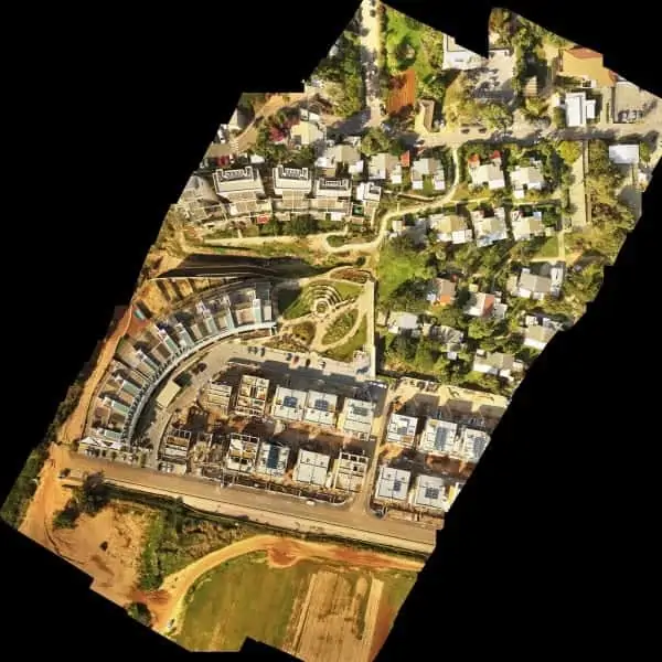
“Together, OneButton and ENVI create a complete image processing and analytics workflow for aerial image data,” said Tom Bosanko, Icaros CEO. “Both packages are highly customizable to meet the needs of specific vertical market applications.”

Icaros developed the OneButton family for geospatial end users to easily and automatically generate precise, fully orthorectified 2D maps and 3D models from frame-based aerial imaging systems. Originally engineered for manned aircraft sensors, the OneButton software has been modified to accommodate the unique collection conditions of unmanned aerial systems (UAS).

“The combination of OneButton and ENVI provide best-of-breed, application-specific image processing and analytics, that enable customers to solve challenging problems related to everything from agriculture and forestry to utilities and city planning,” said Beau Legeer, Business Lead, Data Products at Harris Geospatial Solutions.

OneButton automatically processes raw raster imagery with onboard GPS/IMU data to stich the individual scenes together into a seamless, color-balanced orthomosaic meeting photogrammetric standards. Outputs include digital elevation models (DEMs), true color 3D point clouds, multispectral mosaics and controlled oblique imagery – all ready for ingest directly into the ENVI software environment.

The OneButton family includes a Standard and Professional version. The Standard package asks the end user to specify the application and terrain type for the project at hand. The software then intuitively sets parameters of the photogrammetric engine to perform the mosaicking to the level of precision required. For example, the processing algorithms would handle flat agricultural fields different from a rolling urban landscape.

“The Professional version is more customizable, allowing end users to adjust the processing parameters themselves based on the precision they need, and then edit the resulting mosaic to remove anomalies, like an airplane moving down a runway. OneButton Professional was specifically designed to generate results with the efficiency and accuracy necessary for large scale projects and survey-quality results,” said Bosanko.

OneButton is platform and sensor agnostic, and processes raster image data from small-, medium-, and large-format frame sensors capable of capturing visible RBG, multispectral, near-infrared, and thermal infrared data.

The OneButton solution for ENVI is available now to existing and new customers, and both companies expect further technology integration in the near future around cloud enablement of the UAS data processing and analytics workflow.

Posted by Mike Ball Mike Ball is our resident technical editor here at Unmanned Systems Technology. Combining his passion for teaching, advanced engineering and all things unmanned, Mike keeps a watchful eye over everything related to the unmanned technical sector. With over 10 years’ experience in the unmanned field and a degree in engineering, Mike’s been heading up our technical team here for the last 8 years. Connect & Contact

Latest Articles

Enhancing Security Through Real-Time Video Solutions

LiveU’s Joseph Yaker talks to UST about patented LRT (LiveU Reliable Transport) bonding technology that employs connections like 4G/5G cellular, LEO satellite, Wi-Fi, and Ethernet for highly resilient, and secure real-time video transmission

Feb 12, 2025
Enhancing Autonomous Operations in Orchards with ANELLO GNSS INS

ANELLO Photonics outlines how its GNSS INS technology enhances autonomous operations in orchards, ensuring precise navigation and positioning even in GPS-denied environments

Feb 12, 2025
T-DRONES Introduces New VTOL UAV with Long-Endurance & High Payload Capacity

T-DRONES introduces the VTOL VA32, a versatile unmanned aerial vehicle built for long-duration flights, high payload capacity, and reliable performance in a variety of industrial applications

Feb 12, 2025
Successful UAS Flight Tests Advance Airborne Laser Communication Technology

Cucuyo and Cavok UAS successfully completed flight tests in Spain, validating the integration of the P-100 laser communication terminal and advancing future developments

Feb 12, 2025
High-Precision Three-Axis FOG from MostaTech to Debut at XPONENTIAL Europe

MostaTech is launching the G321M three-axis Fiber Optic Gyroscope (FOG) at XPONENTIAL Europe, delivering enhanced performance, compact design, and magnetic immunity for SWaP-sensitive applications

Feb 12, 2025
IMSAR & TEKEVER Partner to Enhance UAS with Advanced SAR Technology

IMSAR and TEKEVER are set to integrate advanced Synthetic Aperture Radar (SAR) technology into unmanned aerial systems, enhancing surveillance, intelligence, and reconnaissance capabilities for defense and security operations

Feb 11, 2025

Featured Content

Ellipse Series Enhanced with Latest Firmware Upgrade

The new firmware update from SBG Systems integrates the latest World Magnetic Model (WMM) to improve navigation precision, even for first-generation Ellipse sensors

Feb 11, 2025
Advanced FOG-Based Inertial Sensing Solutions for Drones & Robotics

Aegiverse's products feature a multi-layered architecture that combines multiple elements into a compact module, providing significant, size, weight and cost reductions

Feb 06, 2025
Vertiq’s 81-08 G2 Module Added to DIU’s Blue UAS Framework

Vertiq's 81-08 G2 servo motor and control system for Group 2 sUAS has become the first motor and ESC combination to be approved under the U.S. government's Blue UAS Framework

Feb 05, 2025