FAA Announces Public Release of B4UFLY UAS Smartphone App

By Mike Ball / 14 Jan 2016

Smart Sourcing for Unmanned Systems

Discover cutting-edge solutions from leading global suppliers
SUPPLIER SPOTLIGHT
Follow UST

B4UFLY Smartphone AppThe Federal Aviation Administration (FAA) has announced the public release of the B4UFLY mobile application following an initial beta testing period.

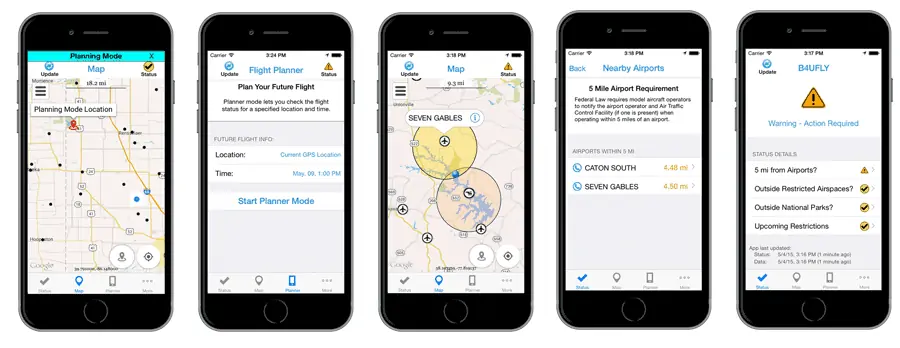
B4UFLY tells users about current or upcoming requirements and restrictions in areas of the National Airspace System (NAS) where they may want to operate their unmanned aircraft system (UAS). The app is now available for Apple devices and can be downloaded from the App Store.

The FAA also is releasing a beta version of B4UFLY for Android devices, which can be downloaded from Google.

“We expect B4UFLY will help raise public awareness about what it means to operate unmanned aircraft safely,” said Michael Huerta, FAA Administrator, at the Consumer Electronics Show in Las Vegas, NV. “It is another important part of our education and awareness efforts to foster a culture of safety and accountability for the UAS community.”

The B4UFLY app includes a number of enhancements the FAA developed as a result of user feedback during the beta testing phase. Within two taps, users know if it is safe to fly at their current location. The app provides a status indicator that tells users: “Proceed with Caution,” “Warning – Action Required,” or “Flight Prohibited.” The app also features a planner mode that allows users to select a different time and location for an upcoming flight and determine if there are any restrictions at that place and time.

By law, hobbyists who want to fly within five miles of an airport must notify the airport operator and the air traffic control facility (if there is one) prior to flying. For now, B4UFLY will ask users who are supposed to notify the airport before flying for voluntary information about their planned flight. This will not meet the statutory requirement to notify the airport and air traffic control facility, but the data will help the agency make informed policy decisions related to notification. This information will not be publicly available.

Posted by Mike Ball Mike Ball is our resident technical editor here at Unmanned Systems Technology. Combining his passion for teaching, advanced engineering and all things unmanned, Mike keeps a watchful eye over everything related to the unmanned technical sector. With over 10 years’ experience in the unmanned field and a degree in engineering, Mike’s been heading up our technical team here for the last 8 years. Connect & Contact

Latest Articles

BotBlox Unveils Compact Solution for 1000BASE-T to 1000BASE-T1 Conversion

BotBlox has unveiled the SPEBlox Module, a compact and efficient solution for converting between standard gigabit Ethernet (1000BASE-T) and gigabit Single Pair Ethernet (1000BASE-T1).

Apr 30, 2025
Embention Strengthens Cybersecurity Frameworks for Aviation Technology

Embention discusses its approach to a structured cybersecurity framework built around ISO 27001 certification, strict internal policies, and secure protocols for safety-critical environments

Apr 30, 2025
Cambridge Pixel Enhances Offshore Monitoring with Advanced Tracking Systems

Cambridge Pixel has partnered with Elcome (India) to deliver radar-based technology supporting the security and monitoring of offshore platforms operated by Reliance Industries

Apr 30, 2025
Collaborative Robots Powering Scalable Automation

Explore how Elite Robots’ cobots are transforming manufacturing by enhancing safety, improving efficiency, and enabling seamless collaboration between humans and machines

Apr 30, 2025
Visualizing Coastal Flood Risks with Global Mapper

Discover how Global Mapper® is being used to model rising tides and predict flood risks in coastal cities like Portland, Maine

Apr 30, 2025
Spexi + LayerDrone: A New Era of Aerial Intelligence

Imagine a real-time, crowd-sourced map of Earth. Spexi, powered by LayerDrone, pays drone pilots to capture ultra-detailed imagery, offering organizations data that’s faster, cheaper, and more precise than traditional methods

Apr 29, 2025

Featured Content

Spexi + LayerDrone: A New Era of Aerial Intelligence

Imagine a real-time, crowd-sourced map of Earth. Spexi, powered by LayerDrone, pays drone pilots to capture ultra-detailed imagery, offering organizations data that’s faster, cheaper, and more precise than traditional methods

Apr 29, 2025
Apollo & Moonrock Launch $122.5m Drone, eVTOL Insurance Facility

Apollo and Moonrock take the lead on new $122.5m drone, eVTOL and aviation innovation insurance facility

Apr 22, 2025
ParaZero Unveils Advanced Parachute Recovery System

ParaZero launches the SafeAir M4, an advanced parachute recovery system designed for the DJI Matrice 4, enhancing drone safety, compliance, and mission readiness

Apr 17, 2025
Advancing Unmanned Systems Through Strategic Collaboration UST works with major OEMs to foster collaboration and increase engagement with SMEs, to accelerate innovation and drive unmanned systems capabilities forward.